
Aramburu Island facts for kids

Aramburu Island from above, looking east, in September 2019.
|
|

Aramburu Island
Location in San Francisco Bay Area

Aramburu Island
Location in California

Aramburu Island
Location in the United States
|
|
| Geography | |
|---|---|
| Location | Northern California |
| Coordinates | 37°53′29″N 122°30′8″W / 37.89139°N 122.50222°W |
| Adjacent bodies of water | Richardson Bay |
| Area | 17 acres (6.9 ha) |
| Administration | |
|
United States
|
|
| State | California |
| County | Marin |
Aramburu Island (say ah-ram-boo-ru) is a 17-acre island in Richardson Bay, Marin County, California. It was formed in the 1950s and 1960s. This happened when people dumped extra material from digging up the bay (called dredging) and from building new homes nearby.
In the 1980s, the northern part of this land was cut off from another area called Strawberry Spit. A local leader in Marin County wanted to stop houses from being built there. This is how Aramburu Island was created. Over time, natural forces like erosion caused the island to shrink. But in the 2010s, a big project added more material to the island. This helped stop erosion and turned it into a great place for birds to live.
Contents
Where is Aramburu Island?

Aramburu Island is located in Richardson Bay. This bay is part of San Francisco Bay, found north of the Golden Gate. The island's exact spot is 37°53′29″N 122°30′8″W / 37.89139°N 122.50222°W.
The island is surrounded by the community of Strawberry. About 1 mile (1.6 km) to the east is the Tiburon Peninsula and the town of Tiburon. A small water channel separates the island from Strawberry Spit to the south. It's not easy to see the island from nearby roads. Only some people living in Strawberry have a view of it.
The island is a nature reserve, which means it's a protected area. Because of this, you can only visit it by boat. Access is limited to protect the wildlife. During the 2020 COVID-19 pandemic in California, public parks were temporarily closed. This meant access to the island was also stopped for a short time.
How Aramburu Island Was Made
-
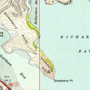
1955 map from the USGS
-
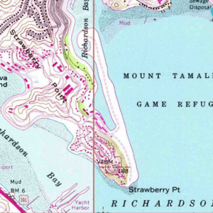
1980 map from the USGS
-
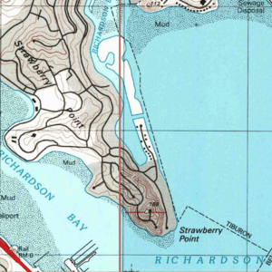
1999 map from the USGS


The land that makes up Aramburu Island and Strawberry Spit was created between the late 1950s and early 1960s. Large amounts of waste material were dumped into Richardson Bay. This material came from digging up the bay to make canals bigger. It also came from building new homes on Strawberry Point.
Aramburu Island and Strawberry Spit were once connected. But in the early 1980s, they were separated. Al Aramburu, a leader in Marin County, ordered a channel to be cut between them. He did this because he didn't want any houses built on the land that became Aramburu Island.
When Aramburu Island was first cut off, it was about 34 acres. However, over the next few decades, the eastern shore of the island began to wear away. This process, called coastal erosion, caused the island to shrink by more than 130 feet (40 m). Today, it is 17 acres. People sometimes described the island as "just a giant pile of dirt" before its restoration.
Making the Island Better
In November 2007, a large ship hit the San Francisco–Oakland Bay Bridge. This caused a big fuel oil spill. About 53,569 US gallons (202,780 liters) of oil spilled into the water. Sadly, nearly 7,000 birds died because of it.
Later, the ship's owner agreed to pay over $32 million to help fix the environment. About $2.4 million of this money was used for Aramburu Island. The total cost of the project was about $4.2 million. Many groups worked together on this, including the National Fish and Wildlife Foundation and Marin County.
Before this, Aramburu Island and other nearby islands were not well known. But in 2011, Marin County started a project to build a new beach on Aramburu Island. They used strong gravel barriers to stop erosion. The work began in the summer. First, they cut back unstable slopes on the east side of the island. Then, they built a "ramp" using materials that were like the Bay's natural beaches. These materials included gravel, sand, ground oyster shells, and eucalyptus logs from local areas.
Plants that didn't belong on the island (called invasive species) covered about 60 percent of the island. These were removed. Then, new plants chosen by scientists were planted. High school students helped by growing these plants in plastic tubes. This project moved tons of material and planted over 36,000 new plants. They also worked to keep Canada geese away. The project was described as "letting nature take its course." In 2017, volunteers were still helping to turn the island into a home for shorebirds. In 2020, an algae bloom covered the shores of Aramburu Island and nearby areas.
Animals on the Island
From the late 1960s, harbor seals sometimes used the island to rest. In 1975, about 30 percent of San Francisco Bay's harbor seal population used the island as a safe place. However, no seals have been seen on the island since 1985.
The island's restoration project, which started in 2011, has helped many birds. The number of birds seen on the island has doubled. Black oystercatchers now live on the island. Between April and October 2012, a report found that black-necked stilts and killdeer were raising their chicks on the island. The report also talked about efforts to keep Canada geese from staying on the island. Different tools were used, like a grid of strings and a sculpture of a coyote, to encourage the geese to leave.
In 2018, scientists studied the island and Richardson Bay for whelk snails. These snails are an "alien species" and can cause problems in the Bay. The study was part of a plan to bring back Olympia oysters to the area. The goal was to stop the invasive snails from harming the oyster population.
See Also
