
Arauco Province facts for kids
Quick facts for kids
Arauco Province
Provincia de Arauco
|
|||||
|---|---|---|---|---|---|

General view of Lebu
|
|||||
|
|||||
| Country | |||||
| Region | Bío Bío | ||||
| Capital | Lebu | ||||
| Comunas | Arauco, Cañete, Contulmo, Curanilahue, Lebu, Los Álamos, Tirúa | ||||
| Government | |||||
| • Type | Provincial | ||||
| Area | |||||
| • Total | 5,643.3 km2 (2,178.9 sq mi) | ||||
| Population
(2002 Census)
|
|||||
| • Total | 157,255 | ||||
| • Density | 27.8658/km2 (72.1721/sq mi) | ||||
| Time zone | UTC-4 (CLT) | ||||
| • Summer (DST) | UTC-3 (CLST) | ||||
| Website | Official website: http://www.gobernacionarauco.gov.cl/ | ||||


The Arauco Province (which is Provincia de Arauco in Spanish) is one of three provinces in the Bío Bío area of Chile. It's like a big county within a larger region. The main city and capital of Arauco Province is Lebu.
Contents
History of Arauco Province
Let's look at how Arauco Province came to be.
Early Beginnings in 1852
The original Arauco Province was created in 1852. It was formed from the southern parts of another province called Concepción. Back then, it had three main areas: Arauco, Laja, and Nacimiento.
Changes Over Time
Things changed quite a bit in 1927. Arauco was no longer its own province and became part of Concepción again. But this didn't last long! In 1934, Arauco was made a province once more. This time, it included the areas of Arauco, Cañete, and Lebu.
Forming the Bío Bío Region
In 1975, regions were created in Chile. The Bío Bío region was formed by combining several provinces. These included Arauco, Biobío, Concepción, and Ñuble. This is how Arauco Province became part of the Bío Bío Region we know today.
Geography of Arauco Province
Arauco Province is located in the southwest part of the Bío Bío region. It stretches along the Pacific Ocean coast.
Size and Location
The province covers an area of about 5,643 square kilometers (2,179 square miles). Its capital city, Lebu, is right on the coast. Lebu is about 90 kilometers (56 miles) south of Concepción, which is the capital of the Bío Bío region.
Neighboring Areas
Arauco Province shares its borders with several other places:
- To the north, it borders the Concepción province.
- To the northeast, you'll find the Biobío province.
- To the east, it touches the Malleco province, which is in the Araucanía region.
- To the south and southwest, it borders the Cautín province, also in the Araucanía region.
- To the west, it meets the vast Pacific Ocean.
 |
Concepción province | Biobío province | |
|
| Pacific Ocean | Malleco province | |||
| Cautín province | Cautín province | Malleco province |
Mocha Island
There's a small island called Mocha located west of Arauco Province in the Pacific Ocean. This island is part of the comuna (a local area) of Lebu. Mocha Island is about 48 square kilometers (18.5 square miles) in size.
Population of Arauco Province
Let's look at how many people live in Arauco Province.
Population Numbers
According to the last national census in 2002, there were 157,255 people living in the province. This means that for every square kilometer, there were about 27.9 people. Most of the people, about 117,569, lived in urban (city) areas. This was about 74.8% of the total population.
Main Cities
Here are some of the largest cities in Arauco Province, based on the 2002 census:
- The biggest city was Curanilahue, with 30,126 people.
- The capital city, Lebu, had 20,838 people.
- Other important cities include Cañete (19,839 people), Arauco (16,291 people), and Los Álamos (13,035 people).
How Arauco Province is Governed
Arauco is a province, which means it's a second-level administrative division in Chile. Think of it as a local government area.
Communes of Arauco
The province is made up of 7 smaller areas called communes (or comunas in Spanish). The city of Lebu is the capital of the province. A governor is in charge of running the province.

Here are the communes that make up Arauco Province:
| Commune | Capital City | Population (2002) |
|---|---|---|
| Lebu | Lebu | 25,035 |
| Arauco | Arauco | 34,873 |
| Cañete | Cañete | 31,270 |
| Contulmo | Contulmo | 5,838 |
| Curanilahue | Curanilahue | 31,943 |
| Los Álamos | Los Álamos | 18,632 |
| Tirúa | Tirúa | 9,664 |
Gallery
-
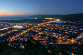
Lebu by night
-
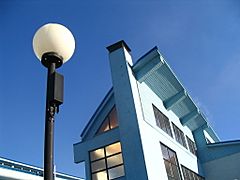
Pablo Neruda school, Curanilahue
-
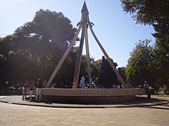
Central square of Cañete
-
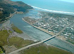
Aerial view of Tirúa


.jpg)

See also
 In Spanish: Provincia de Arauco para niños
