Arch Cape, Oregon facts for kids
Quick facts for kids
Arch Cape, Oregon
|
|
|---|---|

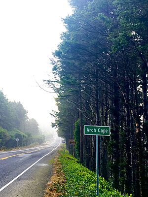
South on Hwy 101 at Arch Cape
|
|
| Country | United States |
| State | Oregon |
| County | Clatsop |
| Elevation | 82 ft (25 m) |
| Population
(2015)
|
|
| • Total | 900 |
| Time zone | UTC-8 (Pacific (PST)) |
| • Summer (DST) | UTC-7 (PDT) |
| ZIP code |
97102
|
| Area codes | 503 & 971 |
| GNIS feature ID | 1117030 |
Arch Cape is a small, quiet community located in Clatsop County, Oregon, in the United States. It's called an "unincorporated community" because it doesn't have its own local government like a city does.
This place gets its name from a cool natural arch you can see in the rocks along the coast. It also has a "cape," which is a piece of land that sticks out into the Pacific Ocean. Arch Cape is about four miles south of Cannon Beach, Oregon. It sits between two state parks: Hug Point State Recreation Site to the north and Oswald West State Park to the south.
Contents
History of Arch Cape
Arch Cape was once a very remote place. In 1912, you could only reach it by a wagon road from Seaside, Oregon. It was quite a journey!
Before 1938, the main highway, U.S. Route 101 in Oregon, ended right at Arch Cape. To make travel easier, workers built a long tunnel through the Arch Cape headland. This tunnel was finished in 1940 and was the longest on Oregon's highway system at the time.
Around 1939, a man named Ernest White built a small home that later became the Arch Cape post office and general store. Today, that building is a hotel called the Inn at Arch Cape.
Before the highway was built, getting to Arch Cape from Cannon Beach was tricky. You had to travel along the beach at low tide, going around a spot called Hug Point. It was only possible to drive a car there when the tide was out!
Arch Cape had a post office as early as 1891. Mail was delivered by foot or horseback until 1912, when train service began. Over the years, the post office moved to different buildings, including the Arch Cape Hotel and later Ernest White's beach house.
You can find a historical marker on Highway 101 that tells an interesting story. It's about the wreck of the USS Shark (1821) in 1846. Three cannons from the ship washed ashore on Arch Cape's beaches! The marker also explains that Arch Cape was once named "Cannon Beach." Later, it changed its name, and a community to the north, Ecola, then took the name Cannon Beach.
Who Lives in Arch Cape?
In 2000, about 205 people lived in Arch Cape. However, during the summer months, the population grows quite a bit! Around 900 people come to enjoy the area.
Exploring Arch Cape's Geography
The Arch Cape headland is a very important and beautiful landmark. It's recognized as a special place for the community and the entire state. Just south of the headland is the northern edge of the Cape Falcon Marine Reserve, an area protected for ocean life.
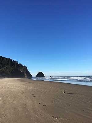
Right off the coast of Arch Cape, you can see Castle Rock. This huge, castle-shaped rock was formed millions of years ago by lava flows. It's a vital spot for birds! More than 10,000 common murres nest here, along with other types of seabirds. It's also a resting place for the endangered brown pelican.
If you love hiking, you'll find the longest unbroken forested part of the Oregon Coast Trail here. It stretches about 8 miles from Arch Cape to Neahkahnie Mountain. The Arch Cape Trail, which starts near Arch Cape Creek, is the longest hiking trail in Oswald West State Park, at 6.3 miles.
In 2008, winter storms uncovered something amazing on Arch Cape beach: a rare "ghost forest"! These giant tree stumps were hidden under deep sand. Scientists believe they are at least 4,000 years old.
Arch Cape's Climate
Arch Cape is part of the North Oregon Coast region. It has mild, dry summers where temperatures don't get too hot. Winters are usually rainy and mild, though it does snow sometimes.
Temperatures in Arch Cape stay pretty steady throughout the year. There's not a huge difference between summer and winter temperatures. The area is also known for its heavy fogs. These fogs form when warm, moist air from the ocean meets the colder land.
According to a group called IQAIR, Arch Cape has some of the cleanest air in the world!
| Weather chart for Arch Cape, Oregon | |||||||||||||||||||||||||||||||||||||||||||||||
|---|---|---|---|---|---|---|---|---|---|---|---|---|---|---|---|---|---|---|---|---|---|---|---|---|---|---|---|---|---|---|---|---|---|---|---|---|---|---|---|---|---|---|---|---|---|---|---|
| J | F | M | A | M | J | J | A | S | O | N | D | ||||||||||||||||||||||||||||||||||||
|
10
38
52
|
8
38
53
|
8.2
39
55
|
5.8
41
57
|
3.8
45
60
|
2.6
50
63
|
1.3
52
66
|
1.2
53
67
|
2.7
49
68
|
5.8
45
63
|
11
41
55
|
11
38
51
|
||||||||||||||||||||||||||||||||||||
| temperatures in °F precipitation totals in inches source: NOAA |
|||||||||||||||||||||||||||||||||||||||||||||||
|
Metric conversion
|
|||||||||||||||||||||||||||||||||||||||||||||||
Life and Work in Arch Cape
Arch Cape doesn't have big stores or restaurants, but it does have a Catholic church and three small hotels. It also has its own fire station, which is part of the Cannon Beach Rural Fire Protection District.
Years ago, a large shingle mill operated along Arch Cape Creek. It was a big business that employed about 40 men. This mill had a huge impact on the area until it burned down in 1967. Today, the Arch Cape Water and Sanitary Districts operate near where the old mill used to be.
Arch Cape is also recognized for its efforts to save water. In 2017, the community received an award for its water conservation program. That same year, there was a plan to buy 2100 acres of land to protect the area's water source and create a community forest.
 | Dorothy Vaughan |
 | Charles Henry Turner |
 | Hildrus Poindexter |
 | Henry Cecil McBay |


