
Ardèche (river) facts for kids
Quick facts for kids Ardèche |
|
| Ardecha | |
| River | |
 The Ardèche river
|
|
| Country | France |
|---|---|
| Regions | Auvergne-Rhône-Alpes, Occitanie |
| Departments | Ardèche, Gard |
| Communes | See list |
| Tributaries | |
| - left | Ubaye, Verdon |
| - right | Buëch, Coulon |
| Cities | Aubenas, Pont-Saint-Esprit |
| Source | Massif Central |
| - location | Astet, Ardèche, Auvergne-Rhône-Alpes, France |
| - elevation | 1,430 m (4,692 ft) |
| - coordinates | 44°42′01″N 4°02′40″E / 44.70028°N 4.04444°E |
| Confluence | Rhône |
| - location | Pont-Saint-Esprit, Gard, Occitanie, France |
| - elevation | 45 m (148 ft) |
| - coordinates | 44°15′52″N 4°38′52″E / 44.26444°N 4.64778°E |
| Length | 125 km (78 mi) |
| Basin | 2,376 km² (917 sq mi) |
| Discharge | for Saint-Martin-d'Ardèche |
| - average | 64.8 m³/s (2,288 cu ft/s) |
The Ardèche (which is Ardecha in Occitan) is a river in south-central France. It is about 125 kilometers (78 miles) long. The Ardèche river flows into the Rhône river from its right side. The French area called the Ardèche department is named after this river.
Contents
Exploring the Ardèche River
The Ardèche river is about 125 kilometers (78 miles) long. The area of land that drains into the river, called its drainage basin, is about 2,376 square kilometers (917 square miles).
The amount of water that flows through the river each second is called its discharge. At a place called Saint-Martin-d'Ardèche, the Ardèche river's average discharge is 64.8 cubic meters (2,288 cubic feet) of water per second.
Where the River Starts and Flows
The Ardèche river begins in the Massif Central mountains. It starts in a special nature park called Parc naturel régional des Monts d'Ardèche. The exact starting point is in a small town called Astet, in the Ardèche department. Here, the river is about 1,430 meters (4,690 feet) above sea level.
The river then flows mostly towards the southwest. It passes by towns like Aubenas and Ruoms. After these towns, it enters a famous deep valley called a gorge or canyon. This part is below a town called Vallon-Pont-d'Arc.
The Ardèche Gorges are very beautiful. This section is about 30 kilometers (19 miles) long. The river here is surrounded by tall limestone cliffs, some as high as 300 meters (980 feet). Many people enjoy going on kayak and camping trips down this gorge in the summer. It's not too hard to do.
The most famous part of the gorge is a natural stone arch that goes over the river. It's about 60 meters (200 feet) wide and is called the Pont d'Arc.
Finally, the Ardèche river joins the Rhône river. This happens near the town of Pont-Saint-Esprit, in the Gard department.
Towns Along the Ardèche
The Ardèche river flows through many towns and areas. These are called communes in France.
- Ardèche :
- Astet
- Mayres
- Barnas
- Thueyts
- Pont-de-Labeaume
- Fabras
- Lalevade-d'Ardèche
- Vals-les-Bains
- Labégude
- Ucel
- Aubenas
- Saint-Privat
- Saint-Didier-sous-Aubenas
- Saint-Étienne-de-Fontbellon
- Vogüé
- Lanas
- Saint-Maurice-d'Ardèche
- Balazuc
- Chauzon
- Pradons
- Ruoms
- Labeaume
- Saint-Alban-Auriolles
- Sampzon
- Vallon-Pont-d'Arc
- Salavas
- Labastide-de-Virac
- Saint-Remèze
- Saint-Martin-d'Ardèche
- Saint-Just
- Gard :
- Aiguèze
- Saint-Julien-de-Peyrolas
- Saint-Paulet-de-Caisson
- Pont-Saint-Esprit
Rivers Joining the Ardèche

Smaller rivers that flow into a larger river are called tributaries. Here are some of the main tributaries that join the Ardèche river:
|
Rivers joining from the left:
|
Rivers joining from the right:
|
Gallery
_2.jpg)


Related pages
Images for kids
-
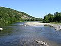
Ardèche River near Aubenas
-
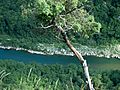
Part of the Ardèche River
-
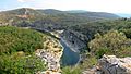
Ardèche River panorama
-
The Ardèche near Aubenas
-
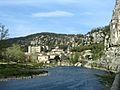
The Ardèche at Vogüé
-
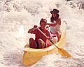
Canoe tourism on the Ardeche
.jpg)


See also
 In Spanish: Río Ardèche para niños
