Summit, Illinois facts for kids
Quick facts for kids
Summit, Illinois
|
||
|---|---|---|
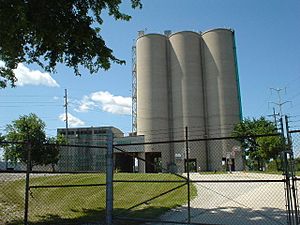
Cement silos in Summit
|
||
|
||
| Motto(s):
Strength, Unity, Progress
|
||
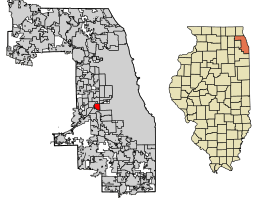
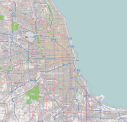
Location of Summit in Cook County, Illinois.
|
||
| Country | United States | |
| State | Illinois | |
| County | Cook | |
| Founded | 1890 | |
| Area | ||
| • Total | 2.26 sq mi (5.85 km2) | |
| • Land | 2.12 sq mi (5.49 km2) | |
| • Water | 0.14 sq mi (0.36 km2) | |
| Population
(2020)
|
||
| • Total | 11,161 | |
| • Density | 5,267.11/sq mi (2,033.86/km2) | |
| Time zone | UTC-6 (CST) | |
| • Summer (DST) | UTC-5 (CDT) | |
| ZIP Code(s) |
60501
|
|
| Area code(s) | 708 | |
| FIPS code | 17-73638 | |
Summit is a town in Cook County, Illinois, USA. In 2020, about 11,161 people lived there. The name 'Summit' has been used since 1836. It means the highest point between the Chicago River and the Des Plaines River, which is just north of the town.
There's also a part of Summit called Argo. It became part of Summit in 1911. Argo was named after a large cornstarch factory nearby. Even though it's part of Summit, many people still use the name "Argo" for this area.
Contents
Exploring Summit's Location
Summit covers about 2.26 square miles (5.85 km2) of land. Most of the town is in the floodplain of the Des Plaines River. This means it's in a low-lying area near the river that can sometimes flood.
A Look Back at Summit's History
Early Days and Native American Life
For about 12,000 years, people have hunted and traveled through the area where Summit is now. However, people have lived there all the time only since about 900 CE. When the first Europeans arrived, different Native American tribes used or lived in the area. These included the Meskwaki, Illini, Miami, Sauk, and Chippewa-Ottawa-Potawatomi tribes.
European Explorers and Trading
In 1673, explorers Marquette and Joliet came to the portage (a place where boats are carried over land) north of Summit. They saw how important this portage was for travel. A trading network grew in the area until Native Americans were moved away starting in 1816.
Building the Illinois and Michigan Canal
In 1830, land in the area was sold by the Illinois and Michigan Canal Commission. By 1835, there was a small settlement called "Summit Corners." It had a tavern, a blacksmith shop, and a stop for stagecoaches. A Chicago politician named "Long John" Wentworth bought a lot of land nearby for farming.
From 1836 to 1848, the Illinois and Michigan Canal was built through the settlement. Many of the workers were Irish immigrants. They were often paid with special money called canal script, which they could use to buy land.
Industries and Railroads Grow
In 1850, people started digging for gravel and clay in the area. After 1865, limestone quarries (places where stone is dug out) opened north of the canal. These quarries provided many jobs until the 1920s.
In 1856, the Joliet and Chicago Railroad built a train line along the canal's south side. Today, this is the Heritage Corridor commuter train line.
Summit Becomes a City
In 1890, Summit officially became a city. People living there were worried that Chicago might try to take over their town. So, they decided to become an official city. The layout of the city was planned much like it is today.
Between 1892 and 1900, the much larger Chicago Sanitary Canal was built. It was just north of the old Illinois and Michigan Canal. In 1900, the new Sanitary Canal opened, and the old canal was no longer used. The old canal in Summit was filled in 1974.
Transportation and Growth
By 1901, electric trains called Interurbans ran on Archer Avenue. These trains connected Summit to Chicago and to Joliet. A branch line also went north to Lyons. By 1933, buses replaced these electric trains.
In 1907, Corn Products Corp. (now Ingredion) started building a huge corn-processing plant south of Summit. This plant was one of the biggest in the world. Near the factory, a new neighborhood called "Argo" was created. In 1911, Summit added Argo to its city limits. Argo grew as a separate community because it was close to the factory and had its own business area.
Between 1910 and 1920, Summit's population grew a lot, from 949 to 4,019 people. By 1930, it reached 6,548. The town changed from a farming area to an industrial one, mostly because of the Corn Products plant. New industries and a large rail yard also brought many jobs.
The city struggled to keep up with this fast growth. Public services like water supply were a big problem, and schools became very crowded. Between 1910 and 1930, three elementary schools, one high school, and two Catholic schools opened to help.
Who Lives in Summit?
| Historical population | |||
|---|---|---|---|
| Census | Pop. | %± | |
| 1880 | 272 | — | |
| 1900 | 547 | — | |
| 1910 | 949 | 73.5% | |
| 1920 | 4,019 | 323.5% | |
| 1930 | 6,548 | 62.9% | |
| 1940 | 7,043 | 7.6% | |
| 1950 | 8,957 | 27.2% | |
| 1960 | 10,374 | 15.8% | |
| 1970 | 11,569 | 11.5% | |
| 1980 | 10,110 | −12.6% | |
| 1990 | 9,971 | −1.4% | |
| 2000 | 10,637 | 6.7% | |
| 2010 | 11,054 | 3.9% | |
| 2020 | 11,161 | 1.0% | |
| U.S. Decennial Census | |||
In 2020, there were 11,161 people living in Summit. There were 3,269 households, which are groups of people living together. About 48% of these households had children under 18 living with them. The average household had about 3.92 people.
The median age in Summit was 32.3 years old. This means half the people were younger than 32.3, and half were older. About 30.3% of the population was under 18 years old.
The median income for a household in Summit was $46,972. This is the middle income for all households. About 17.2% of the people in Summit lived below the poverty line. This included 26.2% of those under 18.
| Race / Ethnicity (NH = Non-Hispanic) | Pop 2000 | Pop 2010 | Pop 2020 | % 2000 | % 2010 | % 2020 |
|---|---|---|---|---|---|---|
| White alone (NH) | 3,912 | 2,662 | 1,791 | 36.78% | 24.08% | 16.05% |
| Black or African American alone (NH) | 1,261 | 1,011 | 852 | 11.85% | 9.15% | 7.63% |
| Native American or Alaska Native alone (NH) | 17 | 28 | 21 | 0.16% | 0.25% | 0.19% |
| Asian alone (NH) | 150 | 199 | 222 | 1.41% | 1.80% | 1.99% |
| Pacific Islander alone (NH) | 0 | 0 | 3 | 0.00% | 0.00% | 0.03% |
| Other race alone (NH) | 6 | 3 | 37 | 0.06% | 0.03% | 0.33% |
| Mixed race or Multiracial (NH) | 135 | 109 | 115 | 1.27% | 0.99% | 1.03% |
| Hispanic or Latino (any race) | 5,156 | 7,042 | 8,120 | 48.47% | 63.71% | 72.75% |
| Total | 10,637 | 11,054 | 11,161 | 100.00% | 100.00% | 100.00% |
Learning in Summit: Schools
Students in elementary and middle school go to Cook County School District 104 schools. After that, they attend Argo Community High School District 217.
Businesses and Jobs in Summit
Summit is home to several important businesses:
- Ingredion runs a huge corn milling and processing plant. This facility is one of the largest of its kind in the world.
- ACH Food Companies has a plant that makes products like Mazola corn oil and Argo Baking Powder.
- The Institute for Food Safety and Health is nearby. It works with the Illinois Institute of Technology and the Food and Drug Administration to make sure food is safe.
- Frito-Lay has an office in Summit.
- The Desplaines Valley News newspaper has been published in Summit since 1913.
Getting Around Summit: Transportation
Summit has many ways to get around:
- The Stevenson Expressway (Interstate 55) runs through the northwest part of the city.
- The Tri-State Tollway (Interstate 294) is about 3 miles (5 km) away.
- Chicago Midway International Airport is about three miles to the east.
- There's a big rail junction called Argo Crossing.
- You can catch Amtrak trains at the Summit (Amtrak station) or use the Metra Heritage Corridor commuter line.
- Chicago Transit Authority and Pace buses also serve the area.
- The historic Illinois and Michigan Canal is also part of the transportation history.
Famous People from Summit
- John Garklāvs: An important leader in the Orthodox Church.
- Fred Hampton: A leader in the Black Panther Party.
- Ted Kluszewski: A famous baseball player for the Cincinnati Reds.
- Clayton Lambert: A pitcher who played for the Reds.
- Sheldon Mallory: An outfielder for the Oakland Athletics.
- Emmett Till: Lived in Argo as a child before moving to Detroit.
- "Long John" Wentworth: A former mayor of Chicago who owned a farm in the area.
Images for kids
See also
 In Spanish: Summit (Illinois) para niños


