Arizpe Municipality facts for kids
Quick facts for kids
Arizpe (municipality)
|
||
|---|---|---|

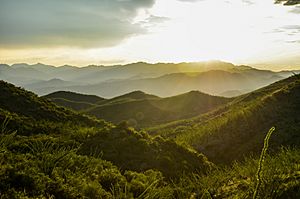
Western Sierra Madre Mountains, Arizpe Sonora
|
||
|
||
| Country | ||
| State | Sonora | |
| Time zone | UTC-7 (Mountain Standard Time) | |
| • Summer (DST) | UTC-7 (No DST) | |

Arizpe is a municipality (like a county) in the Mexican state of Sonora. It is located in the north-central part of Sonora, within the Sierra Madre Occidental mountains.
The Municipality of Arizpe is one of 72 municipalities in Sonora. It has 72 smaller towns and villages. Its main town and capital is also called Arizpe. Other important towns include Sinoquipe, Bacanuchi, and Chinapa.
Arizpe was first called a municipality in 1813. According to the 2020 census by INEGI (Mexico's statistics agency), the municipality has 2,788 people. It covers an area of about 1,186.56 square miles (3,073.17 km2).
The name Arizpe comes from the Opata language. It means "Place of brave ants" or "red ants." The Opata people were the first inhabitants of this region.
Contents
History of Arizpe Municipality
The Opata people lived in this area before the Spanish arrived. In 1646, Jesuit missionaries Jerónimo de la Canal and Ignacio Molarja founded the town of Arizpe. They set it up as a "Mission Town" to teach the Opata people about Christianity.
In 1776, King Charles III of Spain made Arizpe the capital of the Western Internal Provinces. This meant it was a very important city. It had power over a large area, including parts of what are now Arizona, California, Sonora, Sinaloa, Durango, and Chihuahua.
Becoming a Municipality
On March 19, 1812, the first municipalities in the Western State were created. A year later, in 1813, Arizpe officially became an independent municipality. But in 1814, King Ferdinand VII of Spain ended these municipalities.
After Mexico became independent, Arizpe's capital status changed. In 1825, Arizpe was not made a municipality again because it didn't have enough people (it needed at least 3,000).
However, in 1831, a new Constitution divided the state into "parties." Arizpe became the center of the Arizpe Party. In 1832, Arizpe became the capital again until 1838.
Modern Municipality
In 1914, during the Mexican Revolution, the governor ended the old district system. On September 15, 1917, Arizpe was officially named a free municipality. It was then led by a municipal president and four councilors.
Later, in 1930, some nearby municipalities like Banámichi and Baviácora were temporarily joined with Arizpe. This was because they didn't make enough money. But they became independent again in 1931 and remain so today.
Geography of Arizpe
Arizpe municipality is in the center-north part of Sonora. It sits between 2,297 feet (700 meters) and 7,546 feet (2,300 meters) above sea level.
Neighboring Areas
Arizpe shares borders with several other municipalities:
 |
Ímuris | Cananea | Bacoachi |  |
| Cucurpe | Nacozari de García | |||
| Opodepe | Banámichi | Cumpas |
The municipality covers 1,186.56 square miles (3,073.17 km2). This is about 1.7% of Sonora's total area.
Climate and Weather
Arizpe has a dry and semi-warm climate. The average temperature is 68.18°F (20.1°C). The hottest months are July and August, with an average of 84.02°F (28.9°C). The coolest months are February and March, with an average of 52.52°F (11.4°C).
Most of the rain falls in summer, especially in July and August. The area gets about 421.5 millimeters of rain each year. Sometimes, there are frosts from November to February.
Mountains and Rivers
The western part of Arizpe has the Sierra San Antonio mountains. In the east, you'll find the Sierra El Carmen. The Sierra El Manzanal mountains extend into the northern part.
The Sonora River flows through the municipality. It starts in Cananea and flows into the Abelardo L. Rodríguez Dam. The Bacanuchi river also starts in Cananea and flows into the Sonora River. Important streams include Piedras de Lumbre and San Cristóbal. There is also a dam called La Cieneguita.
Plants and Animals
Arizpe has different types of plant life. Near the mountains, there are oak forests. Large areas are covered with grasslands. In the central and southern parts, you can find tropical scrub plants like palo dulce, copal, and different types of cactus like nopal and bilberry cactus. Some small areas along the Sonora River are used for farming.
The municipality is home to many animals:
- Amphibians: toads and frogs.
- Reptiles: river turtles, mountain tortoises, lizards, Sonoran coral snakes, and rattlesnakes.
- Mammals: white-tailed deer, cougars, lynxes, coyotes, wild boars, raccoons, hares, rabbits, gray foxes, squirrels, and field mouses.
- Birds: owls, crows, buzzards, ducks, gray hawks, red-tailed hawks, and doves.
People of Arizpe
In 2020, the municipality of Arizpe had 2,788 people. This means there are about 0.90 people per square kilometer. Of the total population, 1,446 are men and 1,342 are women.
There were 1,555 homes in 2020, with 968 of them being lived in. About 265 of these homes were led by women.
A very small number of people (0.11%) over 3 years old speak a Mexican indigenous language. Also, 0.18% of the people consider themselves Afro-Mexican or of African descent.
Most people in Arizpe (94.51%) are Catholic. About 4.05% are Evangelical Christian or Protestant. A small number (0.18%) follow other religions, and 1.18% do not follow any religion.
Towns and Villages
The municipality has 72 towns and villages. Here are the main ones and their populations:
| Locality | Population |
| Total municipality | 2,788 |
| Arizpe | 1,666 |
| Sinoquipe | 390 |
| Bacanuchi | 183 |
| Chinapa | 139 |
| Tahuichopa | 80 |
| Bamori | 76 |
| Buenavista | 62 |
| El Molino de Bacanuchi | 28 |
| La Nueva Colonia de Chinapa | 13 |
| Basochuca | 12 |
Other small towns include El Derrumbadero, El Álamo, La Bolita, Comatero, and La Galera.
See also
 In Spanish: Municipio de Arizpe para niños
 | James B. Knighten |
 | Azellia White |
 | Willa Brown |


