Armavir, Armenia facts for kids
Quick facts for kids
Armavir
Արմավիր
|
||
|---|---|---|
Armavir
|
||
|
||
| Country | ||
| Marz | Armavir | |
| Founded | 1931 | |
| City status | 1947 | |
| Government | ||
| • Type | Mayor Davit Khudatyan | |
| Area | ||
| • Total | 8.51 km2 (3.29 sq mi) | |
| Elevation | 870 m (2,850 ft) | |
| Population
(2022 census)
|
||
| • Total | 64,000 | |
| • Density | 7,520/km2 (19,480/sq mi) | |
| Time zone | UTC+4 (AMT) | |
| Postal code |
0901-0918
|
|
| Area code(s) | (+374) 237 | |
| Website | Official website: http://armavircity.am/ | |
| Sources: Population | ||
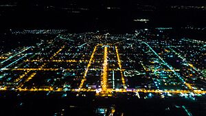
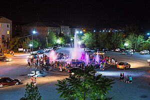
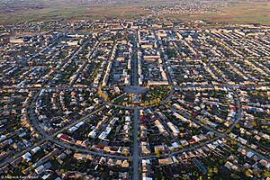
Armavir (Armenian: Արմավիր) is a town in western Armenia. It is the main city of the Armavir Province. The town was started in 1931 by the government of the Armenian Soviet Socialist Republic.
In 2011, about 29,319 people lived there. By 2023, the population grew to around 65,515. Before 1935, the town was called Sardarapat. From 1935 to 1995, it was known as Hoktemberyan. Today, Armavir is an important religious center for the Armenian Apostolic Church.
Contents
Etymology: How Armavir Got Its Name
The town was first called Sardarapat when it was founded in 1931.
Hoktemberyan (1935-1995)
In 1935, its name changed to Hoktemberyan. This name means "city of October." It was chosen to honor the October Revolution, a big event in Russian history.
Armavir (1992-Present)
After Armenia became an independent country in 1991, the town was renamed Armavir in 1992. It was named after a very old city nearby, also called Armavir. That ancient city was built around 800 BC. It even became the capital of the Kingdom of Armenia in 331 BC.
History of Armavir
The area where modern Armavir is located has been lived in for a very long time. People have found old tools and pottery from as far back as 6000 BC.
Ancient Times
Around the 8th century BC, a king named Argishti I of Urartu built a fortress here. He called it Ancient Argishtikhinili. In 331 BC, Armenia became independent from the Achaemenid Empire. At that time, ancient Armavir was chosen as Armenia's capital city.
Historians say that ancient Armavir was the first capital of the Kingdom of Armenia. Over time, many different empires ruled this area. These included the Seleucids, Parthians, Roman Empire, Sassanids, and Byzantine Empire. In 645 AD, the Arabs took control.
Modern Founding and Growth
The modern town of Armavir was officially started on July 26, 1931. It was first called Sardarabat. It was built about 8 kilometers north of the ancient city of Armavir. The town began as a railway station, connecting the cities of Yerevan and Leninakan (now Gyumri). A famous architect named Alexander Tamanian helped design the town.
In 1935, the town's name changed to Hoktemberyan. Many Armenian families moved here from other parts of Armenia and from other countries. In the 1940s, more people, including Yazidis and Kurds, settled in the town. Hoktemberyan became an important industrial center. Because of its fast growth, it was given the status of a town in 1947.
More Armenian families moved to Hoktemberyan in the 1950s and 1960s from countries like Iran, Syria, and Lebanon. In 1966, a branch of the Yerevan Brandy Company opened here. In 1995, after Armenia became independent, Hoktemberyan was renamed Armavir. It became the main city of the new Armavir Province.
Geography and Climate
Modern Armavir covers an area of 8.51 square kilometers. It is located in the fertile Ararat plain. The town is about 47 kilometers west of Armenia's capital, Yerevan.
Location
Armavir is built near several important ancient sites. It is 6 kilometers northeast of the ancient city of Argishtikhinili. It is also 8 kilometers north of the historic Armavir. The area around Armavir is surrounded by many villages. These include Sardarapat and Norapat.
Climate
Armavir has a cold semi-arid climate. This means it has cold winters and hot summers.
| Climate data for Armavir (normals and extremes for 1991-2020) | |||||||||||||
|---|---|---|---|---|---|---|---|---|---|---|---|---|---|
| Month | Jan | Feb | Mar | Apr | May | Jun | Jul | Aug | Sep | Oct | Nov | Dec | Year |
| Record high °C (°F) | 15.0 (59.0) |
21.0 (69.8) |
28.5 (83.3) |
33.0 (91.4) |
35.0 (95.0) |
38.5 (101.3) |
41.5 (106.7) |
40.5 (104.9) |
37.5 (99.5) |
35.0 (95.0) |
24.5 (76.1) |
19.6 (67.3) |
41.5 (106.7) |
| Daily mean °C (°F) | −3.3 (26.1) |
0.0 (32.0) |
6.8 (44.2) |
12.7 (54.9) |
17.4 (63.3) |
22.3 (72.1) |
25.9 (78.6) |
25.8 (78.4) |
20.5 (68.9) |
13.7 (56.7) |
5.8 (42.4) |
−0.7 (30.7) |
12.2 (54.0) |
| Record low °C (°F) | −28.0 (−18.4) |
−24.0 (−11.2) |
−12.2 (10.0) |
−9.6 (14.7) |
0.3 (32.5) |
5.5 (41.9) |
7.3 (45.1) |
9.5 (49.1) |
−2.0 (28.4) |
−4.0 (24.8) |
−10.6 (12.9) |
−28.0 (−18.4) |
−28.0 (−18.4) |
| Average precipitation mm (inches) | 18.2 (0.72) |
17.6 (0.69) |
23.1 (0.91) |
40.5 (1.59) |
44.5 (1.75) |
22.0 (0.87) |
13.1 (0.52) |
8.0 (0.31) |
11.0 (0.43) |
22.9 (0.90) |
19.8 (0.78) |
18.4 (0.72) |
259.1 (10.19) |
| Average precipitation days (≥ 1.0 mm) | 4.2 | 3.8 | 5.3 | 7.3 | 9.1 | 5.3 | 2.7 | 1.9 | 2.3 | 4.9 | 4.2 | 4.8 | 55.8 |
| Average relative humidity (%) | 72.7 | 68.2 | 60.8 | 57.8 | 57.1 | 49.5 | 45.6 | 45.9 | 50.7 | 58 | 64.4 | 71.8 | 58.5 |
| Mean monthly sunshine hours | 70.9 | 111.6 | 162.2 | 177 | 232.8 | 309.8 | 328.3 | 313.6 | 262 | 178.9 | 134.1 | 67.2 | 2,348.4 |
| Source: NOAA | |||||||||||||
Demographics and Religion
When Armavir was founded in 1931, Armenians from different regions settled there. Later, Yazidis, Kurds, and Assyrians from nearby villages also moved to Armavir. In the 1950s and 1960s, many Armenians living abroad returned to Armenia and settled in Armavir.
The town's population grew to about 47,000 people during the Soviet era. After Armenia became independent, the population decreased due to economic changes. However, it has started to grow again in recent years.
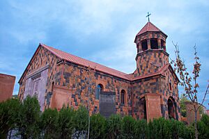
The Saint Gregory of Narek Church in Armavir opened in 2014. It is an important church for the Armenian Apostolic Church in the region. The town also has a medical center with 280 beds.
Culture and Arts
The area around Armavir is rich in history. It has many old archaeological sites. These include Metsamor, ancient Armavir, and ancient Argishtikhinili. These sites show how important this region was in ancient Armenian civilization.
Armavir has a cultural center, a music school, and an arts school. There are also five public libraries and a theater group. The town has a private zoo and botanical garden. In 2016, Armavir celebrated its 85th birthday.
Transportation
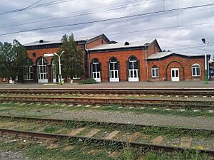
Armavir began as a train station in 1927. It connected Yerevan with Leninakan (now Gyumri). The station was updated in the 2000s. In 2009, an electric train started running, connecting Armavir to other parts of Armenia.
The town is also connected to Yerevan by the M-5 Motorway. The H-17 road links Armavir to Gyumri and northern Armenia.
Economy and Industry
Armavir has become an important center for industry and services. The main industries in the town are food processing and making building materials.
The first big factory in Armavir was a cotton mill, opened in 1928. The Hoktemberyan Cannery, which opened in 1943, was one of the largest food factories in the Soviet Union. The Armavir branch of the Yerevan Brandy Company has been making brandy since 1966. There is also a glass factory that makes glass containers for all of Armenia.
Many banks have branches in Armavir because it is a provincial center. An air base was built near the town in the early 20th century. It was a major training center for jet pilots for the Soviet Air Force.
Education
As of 2015, Armavir has many schools and educational facilities.
- 10 public schools
- 12 nurseries (for young children)
- 2 intermediate colleges
- 3 sport schools
- A school for children with special needs
Armavir is also home to the Tigran Mets Sports and Military College. The Armavir provincial medical center is located in the town as well.
Sports
FC Armavir was the town's football (soccer) club during the Soviet years. It was founded in 1965. After the Soviet Union broke up, the club played in the Armenian Leagues. It closed in 2003 because of money problems. The club played its games at the Jubilee Stadium. This stadium can hold 10,000 people. In 1985, it hosted a match for the 1985 FIFA World Youth Championship. Today, the stadium is used by young football players from the Armavir football school.
In 2017, the Football Federation of Armenia started building a football academy in Armavir. This project is costing about US$3 million. It is being paid for by the Football Federation, UEFA, and FIFA.
Other popular sports in Armavir include martial arts like judo, muay thai, sambo, and taekwondo. A judo tournament called the Mayor's Cup is held every year in Armavir. The town's sport school was fully renovated in 2007.
Twin towns – sister cities
Armavir has special partnerships with other cities around the world. These are called "twin towns" or "sister cities":
See also
 In Spanish: Armavir (Armenia) para niños
 | Aaron Henry |
 | T. R. M. Howard |
 | Jesse Jackson |


