Ashland City, Tennessee facts for kids
Quick facts for kids
Ashland City, Tennessee
|
|
|---|---|

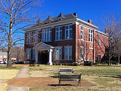
Cheatham County Courthouse in Ashland City
|
|

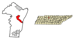
Location of Ashland City in Cheatham County, Tennessee
|
|
| Country | United States |
| State | Tennessee |
| County | Cheatham |
| Founded | 1856 |
| Incorporated | 1859 |
| Area | |
| • Total | 11.41 sq mi (29.56 km2) |
| • Land | 10.67 sq mi (27.63 km2) |
| • Water | 0.75 sq mi (1.93 km2) |
| Elevation | 430 ft (130 m) |
| Population
(2020)
|
|
| • Total | 5,193 |
| • Density | 486.78/sq mi (187.95/km2) |
| Time zone | UTC-6 (Central (CST)) |
| • Summer (DST) | UTC-5 (CDT) |
| ZIP code |
37015
|
| Area code(s) | 615, 629 |
| FIPS code | 47-02180 |
| GNIS feature ID | 1304885 |
Ashland City is a town in Tennessee, United States. It is the main town and county seat of Cheatham County, Tennessee. This means it's where the county government offices are located. Ashland City is part of the larger Nashville area. In 2020, about 5,193 people lived there.
Contents
History of Ashland City
Ashland City was created in 1856. It became the county seat for the new Cheatham County. The county bought 50 acres of land to start the town. A temporary courthouse was built, and then a permanent one in 1869. Ashland City officially became a town in 1859.
Early Industries
The first big business in the area was a forge (a place where metal is heated and shaped). It was run by Montgomery Bell starting in 1818. Later, in 1835, Samuel Watson started a gristmill (for grinding grain) and a powder mill. Watson's powder mill grew to be one of the biggest in the South. It kept running until 1904.
How Ashland City Got Its Name
The town's name might have come from Henry Clay's estate, called Ashland. Another idea is that the General Assembly of Tennessee named it in 1859. They were inspired by the many ash trees in the area. At first, it was just called Ashland. "City" was added after it officially became a town.
Geography
Ashland City is located in the middle of Cheatham County. It sits on the northeast bank of the Cumberland River. This is a few miles upstream from where the Cumberland River meets the Harpeth River. Across the Cumberland River, you'll find the Cheatham State Wildlife Management Area. This area has many hills and is great for nature.
Roads and Connections
Ashland City is at a key meeting point for two main roads. Tennessee State Route 12 connects the town to Nashville to the southeast. It also goes to Clarksville to the northwest. Tennessee State Route 49 connects Ashland City to Springfield and Kentucky to the northeast. It also goes to Charlotte to the west.
The town covers about 11.41 square miles (29.56 square kilometers). Most of this is land, with a small part being water.
Landmarks
Sydney's Bluff
Sydney's Bluff is a jagged cliff system. It is located across the Cumberland River from Ashland City. You can see it from many parts of the town. The Cumberland River carved out these cliffs. They are popular for rock climbing and hiking. The bluff is said to be named after a girl who fell from it long ago.
Cheatham Lake
Cheatham Lake is a large area for fun and relaxation. It stretches up the Cumberland River past Ashland City. The US Army Corps of Engineers manages it. The lake was formed by the Cheatham Lock and Dam. This dam is about 11 miles northwest of the town. Cheatham Lake offers many outdoor activities. These include camping, fishing, watching wildlife, and water sports. It's a popular spot for a rustic weekend trip.
Demographics
| Historical population | |||
|---|---|---|---|
| Census | Pop. | %± | |
| 1870 | 121 | — | |
| 1880 | 170 | 40.5% | |
| 1890 | 358 | 110.6% | |
| 1910 | 641 | — | |
| 1920 | 649 | 1.2% | |
| 1930 | 712 | 9.7% | |
| 1940 | 957 | 34.4% | |
| 1950 | 1,024 | 7.0% | |
| 1960 | 1,400 | 36.7% | |
| 1970 | 2,027 | 44.8% | |
| 1980 | 2,329 | 14.9% | |
| 1990 | 2,552 | 9.6% | |
| 2000 | 3,641 | 42.7% | |
| 2010 | 4,541 | 24.7% | |
| 2020 | 5,193 | 14.4% | |
| Sources: | |||
2020 Census Information
| Race | Number | Percentage |
|---|---|---|
| White (non-Hispanic) | 4,175 | 80.4% |
| Black or African American (non-Hispanic) | 309 | 5.95% |
| Native American | 10 | 0.19% |
| Asian | 32 | 0.62% |
| Pacific Islander | 11 | 0.21% |
| Other/Mixed | 230 | 4.43% |
| Hispanic or Latino | 426 | 8.2% |
In 2020, there were 5,193 people living in Ashland City. These people lived in 1,986 households. There were also 1,129 families in the town.
Economy
Ashland City has several important businesses. The biggest factory is A. O. Smith. This company makes water heaters. The town's borders recently grew to include the Cheatham County Industrial Park. This park has businesses like Caymas Boats. It also has companies that build barges, make paper products, and produce concrete. These businesses are located along the Cumberland River. The Nashville & Western Railroad helps serve the industries in Ashland City.
Images for kids
See also
 In Spanish: Ashland City para niños
 | Delilah Pierce |
 | Gordon Parks |
 | Augusta Savage |
 | Charles Ethan Porter |


