Astronomical coordinate systems facts for kids

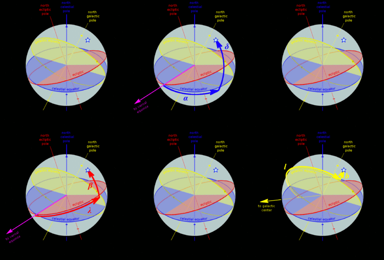
A star's galactic, ecliptic, and equatorial coordinates, as projected on the celestial sphere. Ecliptic and equatorial coordinates share the March equinox as the primary direction, and galactic coordinates are referred to the galactic center. The origin of coordinates (the "center of the sphere") is ambiguous; see celestial sphere for more information.
|
Astronomical coordinate systems are like special maps that help us find the exact location of objects in space, such as planets, stars, and galaxies. Imagine trying to give directions to a friend for a star without a map – it would be really hard! These systems use specific points and lines in space as reference points, just like how we use latitude and longitude to find places on Earth.
Sometimes, we need to know an object's exact spot in three-dimensional space. Other times, we just need to know its direction on the celestial sphere. The celestial sphere is an imaginary giant ball surrounding Earth, where all celestial objects appear to be located.
These space maps often use a system similar to the geographic coordinate system we use on Earth. They have a main flat surface called a fundamental plane, which divides the celestial sphere into two equal halves. They also have poles (like the North and South Poles on Earth) and a primary direction (a starting line for measurements). Each coordinate system is named after its main plane.
Contents
Main Sky Maps
Astronomers use several different coordinate systems, depending on what they are observing and from where. Here are some of the most common ones:
| Coordinate system | Center point | Fundamental plane | Poles | What it measures | Primary direction |
|---|---|---|---|---|---|
| Horizontal | The observer (you!) | Horizon | Zenith (straight up), nadir (straight down) | Altitude (how high up) and Azimuth (direction around the horizon) | North or south point of horizon |
| Equatorial | Center of the Earth or Sun | Celestial equator (Earth's equator extended into space) | Celestial poles (Earth's poles extended into space) | Declination (north/south of celestial equator) and Right ascension (east/west along celestial equator) | March equinox (where the Sun crosses the celestial equator in spring) |
| Ecliptic | Center of the Earth or Sun | Ecliptic (the plane of Earth's orbit around the Sun) | Ecliptic poles | Ecliptic latitude (north/south of ecliptic) and Ecliptic longitude (east/west along ecliptic) | March equinox |
| Galactic | Center of the Sun | Galactic plane (the flat disk of our Milky Way Galaxy) | Galactic poles | Galactic latitude (north/south of galactic plane) and Galactic longitude (around the galactic plane) | Galactic Center |
| Supergalactic | Supergalactic plane (a plane containing many nearby galaxies) | Supergalactic poles | Supergalactic latitude and Supergalactic longitude | Intersection of supergalactic plane and galactic plane |
Horizontal System
The horizontal system is all about where you are standing on Earth. It uses your local horizon as its main reference. This system is super useful for finding objects right now, from your exact spot. For example, if you're looking at a star, its position in the horizontal system changes as Earth rotates. It tells you how high the object is above the horizon (its altitude) and its direction around the horizon (its azimuth).
Equatorial System
The equatorial system is centered on Earth, but it's fixed in relation to the distant stars. Imagine Earth's equator and poles stretching out into space – that's what this system uses! It's the most common system for modern star maps and for professional astronomers. When astronomers use telescopes with special mounts that follow the sky's movement, they often use equatorial coordinates to find objects.
Ecliptic System
The ecliptic system uses the flat path that Earth takes as it orbits the Sun as its main plane. This path is called the ecliptic. There are two main types:
- Geocentric ecliptic coordinates are centered on Earth. This system was very important for ancient astronomers and is still good for tracking the Sun, Moon, and planets as seen from Earth.
- Heliocentric ecliptic coordinates are centered on the Sun. This system is used to understand how planets and other objects in our Solar System move around the Sun.
Galactic System
The galactic system uses the flat disk of our own Milky Way Galaxy as its main plane. It helps us map objects within our galaxy. The center of this system is still our Solar System, but the measurements are based on the direction towards the Galactic Center (the center of the Milky Way). It tells you how far above or below the galactic plane an object is, and its direction around the galaxy's center.
Supergalactic System
The supergalactic system is used for mapping very large structures in the universe, like huge groups of galaxies. Its main plane is set up to align with a region where many local galaxies are found.
See also
 In Spanish: Coordenadas celestes para niños
- Apparent longitude
- Azimuth
- Barycentric and geocentric celestial reference systems
- Celestial sphere
- International Celestial Reference System and its realizations
- Orbital elements
- Planetary coordinate system
- Terrestrial reference frame
 | May Edward Chinn |
 | Rebecca Cole |
 | Alexa Canady |
 | Dorothy Lavinia Brown |

