Atkinson County, Georgia facts for kids
Quick facts for kids
Atkinson County
|
|
|---|---|

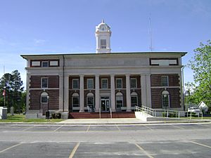
Atkinson County Courthouse in Pearson
|
|

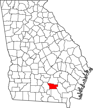
Location within the U.S. state of Georgia
|
|
 Georgia's location within the U.S. |
|
| Country | |
| State | |
| Founded | August 15, 1917 |
| Named for | William Yates Atkinson |
| Seat | Pearson |
| Largest city | Pearson |
| Area | |
| • Total | 345 sq mi (890 km2) |
| • Land | 339 sq mi (880 km2) |
| • Water | 5.2 sq mi (13 km2) 1.5%% |
| Population
(2020)
|
|
| • Total | 8,286 |
| • Density | 24/sq mi (9/km2) |
| Time zone | UTC−5 (Eastern) |
| • Summer (DST) | UTC−4 (EDT) |
| Congressional district | 8th |
Atkinson County is a county found in the southeastern part of the U.S. state of Georgia. In 2020, about 8,286 people lived there. The main town and county seat is Pearson.
Atkinson County was created in 1917. It was formed from parts of Coffee and Clinch counties. The county is named after William Yates Atkinson. He was a Democratic governor of Georgia from 1894 to 1898.
Contents
Exploring Atkinson County's Geography
According to the U.S. Census Bureau, Atkinson County covers a total area of about 345 square miles. Most of this area, 339 square miles, is land. The remaining 5.2 square miles (about 1.5%) is water. This county is a part of Southeast Georgia.
Most of Atkinson County is located in the Satilla River area. This river basin is part of the larger St. Marys-Satilla River system. A smaller part of the western border, near Willacoochee, is in the Alapaha River area. This river flows into the Suwannee River. A tiny corner in the southeast also belongs to the Upper Suwannee River basin.
Main Roads in Atkinson County
These are the major highways that run through Atkinson County:
Neighboring Counties
Atkinson County shares borders with these other counties:
- Coffee County - to the north
- Ware County - to the east
- Clinch County - to the south
- Lanier County - to the southwest
- Berrien County - to the west
Towns and Villages
Atkinson County has a few communities within its borders.
Cities
Unincorporated Communities
These are smaller communities that are not officially organized as cities:
- Kirkland
- Axson
People and Population in Atkinson County
| Historical population | |||
|---|---|---|---|
| Census | Pop. | %± | |
| 1920 | 7,656 | — | |
| 1930 | 6,894 | −10.0% | |
| 1940 | 7,093 | 2.9% | |
| 1950 | 7,362 | 3.8% | |
| 1960 | 6,188 | −15.9% | |
| 1970 | 5,879 | −5.0% | |
| 1980 | 6,141 | 4.5% | |
| 1990 | 6,213 | 1.2% | |
| 2000 | 7,609 | 22.5% | |
| 2010 | 8,375 | 10.1% | |
| 2020 | 8,286 | −1.1% | |
| 2023 (est.) | 8,293 | −1.0% | |
| U.S. Decennial Census 1790-18801890-1910 1920-1930 1930-1940 1940-1950 1960-1980 1980-2000 2010-2019 |
|||
The population of Atkinson County has changed over the years. In 1920, there were 7,656 residents. The population went down to 5,879 in 1970. By 2010, it reached its highest point with 8,375 people. In 2020, the population was 8,286.
| Race | Num. | Perc. |
|---|---|---|
| White (non-Hispanic) | 4,801 | 57.94% |
| Black or African American (non-Hispanic) | 1,208 | 14.58% |
| Native American | 30 | 0.36% |
| Asian | 12 | 0.14% |
| Pacific Islander | 4 | 0.05% |
| Other/Mixed | 183 | 2.21% |
| Hispanic or Latino | 2,048 | 24.72% |
In 2010, the county's population was mostly white (62.2%). About 17.3% were Black or African American. People of Hispanic or Latino origin made up 24.3% of the population. By 2020, the number of non-Hispanic white residents went down to 57.94%. The African American population also decreased to 14.58%. However, the Hispanic or Latino American population grew to 24.72%. This shows the county is becoming more diverse, like many places in the U.S.
In 2020, the average income for a household in Atkinson County was about $35,703. For families, the average income was $46,086. In 2022, about 27.5% of the county's population lived below the poverty line.
As of 2022, there were 3,063 households in Atkinson County. Each household had an average of 2.7 people. About 66% of these households were married couples. Most homes (67%) were owned by the people living in them. The average value of these homes was $77,100.
Atkinson County is part of the Bible Belt. This means most people in the county who are religious follow Christianity. In 2020, the largest Christian group was the Southern Baptist Convention. Other important groups included the Church of Jesus Christ of Latter-day Saints and African Methodist Episcopal Church. Pentecostalism was also a significant tradition.
Education in Atkinson County
The Satilla Regional Library System serves Atkinson County. It also serves Coffee County.
See also
 In Spanish: Condado de Atkinson para niños
 | Toni Morrison |
 | Barack Obama |
 | Martin Luther King Jr. |
 | Ralph Bunche |

