Atna Peaks facts for kids
Quick facts for kids Atna Peaks |
|
|---|---|

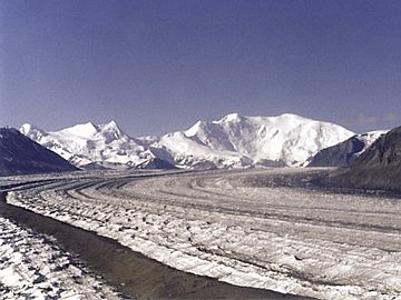
The Nabesna Glacier, with Mount Blackburn at right; Atna Peaks is the twin summit left of center and Parka Peak is the icy summit at left
|
|
| Highest point | |
| Elevation | 13,860 ft (4,220 m) |
| Prominence | 2,160 ft (660 m) |
| Isolation | 3.7 mi (6.0 km) |
| Listing |
|
| Geography | |
| Location | Valdez-Cordova Census Area, Alaska, U.S. |
| Parent range | Wrangell Mountains |
| Topo map | USGS McCarthy C-6 |
| Geology | |
| Mountain type | Eroded stratovolcano or shield volcano |
| Last eruption | Unknown |
| Climbing | |
| First ascent | Alex Bittenbinder, Don Stockard, and Vin Hoeman, 1965 |
| Easiest route | glacier climb |
Atna Peaks is a tall mountain in the Wrangell Mountains of eastern Alaska. It's a type of volcano that has been worn down over a very long time. Scientists think it might be an old stratovolcano or a shield volcano.
This mountain is inside Wrangell–Saint Elias National Park. It's about 6 miles (10 km) east of Mount Blackburn. Mount Blackburn is the second-highest volcano in the United States. Atna Peaks is also just south of the huge Nabesna Glacier.
Because Atna Peaks is mostly covered in glaciers, it's hard for scientists to study its rocks. But maps and older reports show that it is indeed an ancient volcano.
How Tall is Atna Peaks?
The main top of Atna Peaks is 13,860 feet (4,225 meters) high. This makes it the second-highest "thirteener" in Alaska. A "thirteener" is a mountain peak that is between 13,000 and 13,999 feet tall.
Other Peaks Nearby
Atna Peaks actually has more than one summit. Another top is about 0.6 miles (1 km) to the east. It is over 13,600 feet (4,145 meters) high.
There is also another named peak called Parka Peak. It is about 13,280 feet (4,048 meters) tall. Parka Peak is about 1.6 miles (2.6 km) further east. It is separated from Atna Peaks by a saddle covered in ice.
The steep, rocky southern sides of these three peaks form part of the cirque of the Kennicott Glacier. A cirque is a bowl-shaped valley carved by a glacier. The Kennicott Glacier flows southeast for over 20 miles (32 km). It ends just above the town of McCarthy.
How Atna Peaks Got Its Name
Atna Peaks was given its name in 1965. This happened when the first group of climbers reached its top. They were from the Mountaineering Club of Alaska.
They chose the name "Atna" because the peaks are close to the Copper River. The old Native American name for that river was "Atna."

 | Misty Copeland |
 | Raven Wilkinson |
 | Debra Austin |
 | Aesha Ash |

