
Atwell Peak facts for kids
Quick facts for kids Atwell Peak |
|
|---|---|

Atwell Peak
|
|
| Highest point | |
| Elevation | 2,655 m (8,711 ft) |
| Prominence | 125 m (410 ft) |
| Listing | List of volcanoes in Canada List of Cascade volcanoes |
| Geography | |

Atwell Peak
Location in British Columbia
|
|
| Location | British Columbia, Canada |
| Parent range | Garibaldi Ranges |
| Topo map | NTS 92G/14 |
| Geology | |
| Age of rock | Pleistocene |
| Mountain type | Lava dome |
| Volcanic arc/belt | Canadian Cascade Arc Garibaldi Volcanic Belt |
| Last eruption | Pleistocene |
| Climbing | |
| First ascent | 1911 A. Armistead; B. Darling; J. Davies; F. Hewton; A. Morkill |
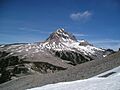
Atwell Peak is a cool, pyramid-shaped volcanic mountain in British Columbia, Canada. It sits at the southern edge of a bigger mountain called Mount Garibaldi. Atwell Peak was formed a long time ago, between 0.51 and 0.22 million years ago. It was the source of many fast-moving flows of hot ash and rock during Mount Garibaldi's early days.
When you look from Squamish, people often think Atwell Peak is Mount Garibaldi. That's because the main peak of Mount Garibaldi is hidden behind it! The west side of Atwell Peak has steep slopes that drop into the Cheekye River. This area often has landslides.
Atwell Peak has three main ridges: the north, east, and south. These ridges are like the "spines" of the mountain. The north and south ridges are the easiest to see.
Contents
What is Atwell Peak?
Atwell Peak is part of a larger group of mountains called the Garibaldi Massif. This whole area is an eroded volcano that was shaped during the last ice age. Atwell Peak is also part of the Garibaldi Volcanic Belt. This belt is a section of the Canadian Cascade Arc, which is a chain of volcanoes. Even though it's part of this chain, Atwell Peak is not actually inside the main Cascade Range mountains. It's located in the Garibaldi Ranges of the Pacific Ranges.
Climbing Atwell Peak
Climbing Atwell Peak is usually done in winter or early spring. This is because the rock on the mountain is very loose and crumbly. When it's frozen, it's much safer to climb.
Climbing Routes
Atwell Peak has three main ridges: the north, east, and south. The east ridge connects to the north ridge a bit north of the very top. In winter and spring, these ridges can be sharp and have lots of snow overhangs called cornices. The north ridge is the shortest way to climb to the top.
There are also several routes on the southeast face of the peak. These routes are not too difficult and eventually lead to one of the three main ridges. The northeast face is the shortest side of the peak, but it has many deep cracks in the ice called bergschrunds.
Ice and Glaciers Around Atwell Peak
To the east of Atwell Peak, you'll find a large area of ice called the Garibaldi Névé ice field. This is a popular spot for people who enjoy ski touring.
Nearby Glaciers
Right below the east side of Atwell Peak, there are two smaller glaciers:
- The Diamond Glacier is to the southeast.
- The upper Bishop Glacier is to the northeast.
Just north of Atwell Peak, towards Mount Garibaldi, there's a small ice cap high up on the mountain called the Cheekye Glacier.
Images for kids
-
Atwell Peak
