August 2016 Central Italy earthquake facts for kids
 |
|
| UTC time | 2016-08-24 01:36:32 |
|---|---|
| ISC event | 611462212 |
| USGS-ANSS | ComCat |
| Local date | 24 August 2016 |
| Local time | 03:36 CEST |
| Magnitude | 6.2 Mw |
| Depth | 4.4 km (2.7 mi) |
| Epicenter | 42°42′22″N 13°13′23″E / 42.706°N 13.223°E |
| Type | Dip-slip (normal) |
| Areas affected | Central Italy |
| Max. intensity | XI (Extreme) |
| Casualties | 299 deaths ≈ 388 injured 4,500 homeless |
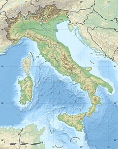
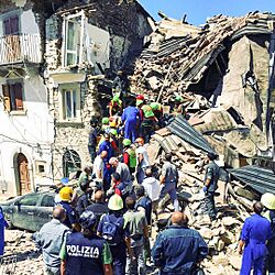
On August 24, 2016, a strong earthquake with a magnitude of 6.2 hit Central Italy. It happened at 3:36 AM local time. The earthquake's center, called the epicentre, was near the town of Accumoli. The shaking started about 4 kilometers (2.5 miles) deep underground. This area is close to the borders of the Umbria, Lazio, Abruzzo, and Marche regions. Sadly, 299 people lost their lives in this event.
Contents
Why Earthquakes Happen in Italy
The central Apennines are a very active earthquake zone in Italy. These mountains formed over millions of years. This happened because the Adriatic Plate is slowly sliding under the Eurasian Plate. This movement creates a lot of pressure and changes in the Earth's crust.
Over time, the way the Earth's plates move here changed. Now, the land is pulling apart, causing normal faults. These are cracks in the Earth's crust where blocks of rock slide past each other. Recent big earthquakes in this area have been caused by these normal faults moving.
This 2016 earthquake was the biggest tremor since 2009. In 2009, an earthquake near L'Aquila killed over 300 people. It also left about 65,000 people without homes.
The August 2016 Earthquake
The earthquake was first reported to be about 5 kilometers (3 miles) deep. Its magnitude was measured at 6.0, with the epicentre in the town of Accumoli. Other groups, like the USGS, first reported a magnitude of 6.4. They later changed it to 6.2. The first shaking was felt at 3:36 AM.
Different groups sometimes report slightly different earthquake measurements. This is because they use different ways to calculate the magnitude. For example, some use models made specifically for Italy. Others use global models.
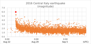
By August 30, 2016, the main earthquake had been followed by at least 2,500 smaller quakes. These smaller quakes are called aftershocks. The main earthquake and many aftershocks were felt across central Italy. This included big cities like Rome, Florence, and Bologna.
The local school in the affected area was quickly repaired. It reopened to students on September 15, 2016.
| Date | ≥6.0 | 5.0–5.9 | 4.0–4.9 | 3.0–3.9 | 2.0–2.9 | 1.0–1.9 | ≤0.9 | Total |
|---|---|---|---|---|---|---|---|---|
| 24 Aug | 1 | 1 | 7 | 83 | 214 | 46 | 0 | 352 |
| 25 Aug | 0 | 0 | 2 | 8 | 228 | 233 | 1 | 472 |
| 26 Aug | 0 | 0 | 1 | 14 | 190 | 178 | 2 | 385 |
| 27 Aug | 0 | 0 | 1 | 9 | 130 | 330 | 6 | 476 |
| 28 Aug | 0 | 0 | 1 | 9 | 86 | 351 | 6 | 453 |
| 29 Aug | 0 | 0 | 0 | 5 | 71 | 268 | 8 | 352 |
| 30 Aug | 0 | 0 | 0 | 4 | 69 | 308 | 22 | 403 |
| 31 Aug | 0 | 0 | 0 | 9 | 53 | 355 | 22 | 439 |
| Date | Local time (CEST) |
Moment magnitude |
Hypocenter depth |
Epicenter | ||
|---|---|---|---|---|---|---|
| Municipality | Latitude | Longitude | ||||
| 24 August 2016 | 03:36:32 | 6.2 | 10 km (6.2 mi) | Norcia | 42.71 | 13.17 |
| 24 August 2016 | 03:56:02 | 4.6 | 10 km (6.2 mi) | Amatrice | 42.61 | 13.28 |
| 24 August 2016 | 04:33:29 | 5.5 | 10 km (6.2 mi) | Norcia | 42.79 | 13.15 |
| 24 August 2016 | 04:59:35 | 4.3 | 9 km (5.6 mi) | Norcia | 42.80 | 13.14 |
| 24 August 2016 | 05:40:11 | 4.3 | 10.7 km (6.6 mi) | Amatrice | 42.62 | 13.25 |
| 24 August 2016 | 06:06:53 | 4.4 | 10 km (6.2 mi) | Cascia | 42.75 | 13.03 |
| 24 August 2016 | 13:50:31 | 4.9 | 10 km (6.2 mi) | Visso | 42.87 | 13.11 |
| 24 August 2016 | 13:50:57 | 4.1 | 8 km (5.0 mi) | Arquata del Tronto | 42.82 | 13.15 |
| 24 August 2016 | 19:46:09 | 4.6 | 10 km (6.2 mi) | Arquata del Tronto | 42.72 | 13.19 |
| 25 August 2016 | 01:22:06 | 4.1 | 7.3 km (4.5 mi) | Maltignano | 42.67 | 13.14 |
| 25 August 2016 | 05:17:16 | 4.7 | 10 km (6.2 mi) | Norcia | 42.78 | 13.18 |
| 25 August 2016 | 05:36:07 | 4.3 | 10 km (6.2 mi) | Maltignano | 42.65 | 13.16 |
| 26 August 2016 | 06:28:27 | 4.7 | 10 km (6.2 mi) | Amatrice | 42.66 | 13.25 |
| 27 August 2016 | 04:50:59 | 4.2 | 12.2 km (7.6 mi) | Norcia | 42.83 | 13.15 |
| 28 August 2016 | 15:07:34 | 4.3 | 11.7 km (7.3 mi) | Amatrice | 42.66 | 13.24 |
| 28 August 2016 | 17:55:36 | 4.6 | 5.7 km (3.5 mi) | Norcia | 42.78 | 13.15 |
| 28 August 2016 | 18:42:02 | 4.3 | 10 km (6.2 mi) | Visso | 42.86 | 13.03 |
People Affected and Rescue Efforts
| Nationality | Dead | Injured |
|---|---|---|
| 280 | 376 | |
| 11 | 6 | |
| 3 | 2 | |
| 1 | 7 | |
| 1 | 1 | |
| 1 | 1 | |
| 1 | ||
| 1 | ||
| - | 2 | |
| - | 1 |
The earthquake caused the deaths of 297 people. Most of these deaths, 234, were in Amatrice. Another 11 people died in Accumoli, and 49 in Arquata del Tronto. At least 365 injured people needed hospital care. Many others with less serious injuries were treated right away.
Rescue teams worked quickly to help people. In total, 238 people were pulled alive from the rubble. The Vigili del Fuoco (Italian firefighters) rescued 215 people. The Soccorso Alpino (mountain rescue) saved 23 others.
About 2,100 people had to stay in emergency camps. Around 4,400 people helped with search and rescue. This included 70 teams with rescue dogs. Helicopters were also used to help with the rescue efforts.
The earthquake killed 280 Italians and 11 Romanians. People from other countries also lost their lives. You can see a full list of nationalities in the table.
Damage Caused by the Earthquake
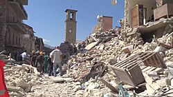
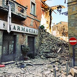
The earthquake caused a lot of damage, especially in the town of Amatrice. This town was very close to the earthquake's center. The towns of Accumoli and Pescara del Tronto also suffered severe damage. The mayor of Amatrice said that "Amatrice is not here anymore." He explained that half of the town was destroyed.
Pictures showed huge piles of rubble where buildings once stood. Only a few structures on the edges of the town remained. The earthquake also caused a lot of financial loss. It was estimated to be between $1 billion and $11 billion.
Damage to Important Historical Sites
Besides the loss of life, many important historical buildings were also damaged. These are part of Italy's cultural heritage.
In Amatrice, the front and rose window of the Church of Sant'Agostino were destroyed. A museum dedicated to the painter Nicola Filotesio also collapsed. The earthquake even caused cracks in the ancient Baths of Caracalla in Rome. Authorities checked the Colosseum too, but it was not damaged.
The Basilica of Saint Francis of Assisi is a UNESCO World Heritage site. It has famous paintings by Giotto and Cimabue. Parts of it were damaged by an earthquake in 1997. After this 2016 earthquake, experts checked it and said it was safe.
Later Earthquakes in 2016 and 2017
A magnitude 6.1 earthquake hit Italy near Visso on October 26, 2016. This was about 30 kilometers (19 miles) northwest of where the August earthquake happened. It was first thought to be an aftershock of the August quake. One man died from a heart attack caused by the shaking.
On October 30, 2016, an even stronger earthquake hit Norcia. It had a magnitude of 6.6. This was larger than the August 24 shock.
On January 18, 2017, a magnitude 5.3 earthquake struck northwest of L'Aquila. This happened at 10:25 AM. A stronger 5.7 tremor hit the same area later that morning. Then, an 11 minutes later, a third quake of magnitude 5.6 occurred. A fourth tremor of magnitude 5.2 was registered in the afternoon. These earthquakes were followed by many aftershocks.
Images for kids
See also
 In Spanish: Terremoto de Italia central de agosto de 2016 para niños
- 1639 Amatrice earthquake
- List of earthquakes in 2016
- List of earthquakes in Italy
- October 2016 Central Italy earthquakes
- January 2017 Central Italy earthquakes
 | Delilah Pierce |
 | Gordon Parks |
 | Augusta Savage |
 | Charles Ethan Porter |


