
Azurite Peak facts for kids
Quick facts for kids Azurite Peak |
|
|---|---|

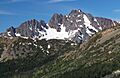
Azurite Peak seen from northeast
|
|
| Highest point | |
| Elevation | 8,400 ft (2,600 m) |
| Prominence | 1,880 ft (570 m) |
| Isolation | 5.20 mi (8.37 km) |
| Parent peak | Tower Mountain (8,444 ft) |
| Geography | |

Azurite Peak
Location in Washington (state)

Azurite Peak
Location in the United States
|
|
| Location | Okanogan, Skagit, Whatcom counties Washington, U.S. |
| Parent range | North Cascades |
| Topo map | USGS Azurite Peak |
| Climbing | |
| First ascent | 1933, Hermann Ulrichs, Sidney Shmerling |
| Easiest route | Scrambling, class 4 |
Azurite Peak is a tall mountain in Washington state. It has two main tops, like a double peak. This mountain is about 8,400-foot (2,600-metre) high. It sits where three counties meet: Okanogan, Skagit, and Whatcom.
Azurite Peak is part of the Okanogan Range. This range is a smaller part of the larger North Cascades mountains. The mountain is north of Azurite Pass. It is managed by the Okanogan National Forest.
The closest taller mountain is Tower Mountain. It is about 5.24 miles (8.43 km) to the south-southeast. Mount Ballard is about 1.97 miles (3.17 km) to the north. You can find small pieces of a glacier on the east side of Azurite Peak. The famous Pacific Crest Trail also goes near the base of the mountain.
Weather at Azurite Peak
Azurite Peak is in a place with a "marine west coast" climate. This means it gets a lot of weather from the Pacific Ocean. Most weather systems move from the Pacific Ocean towards the Cascade Mountains.

When these weather systems reach the North Cascades, the mountains push the air upwards. This makes the air cool down and drop its moisture. This moisture falls as rain or snow. This process is called "orographic lift." Because of this, the western side of the North Cascades gets a lot of rain and snow, especially in winter.
In winter, the weather is often cloudy. But in summer, high pressure systems over the Pacific Ocean bring clear skies. The snow here tends to be wet and heavy. This can make avalanches more likely.
How Azurite Peak Formed
The North Cascades mountains have very rugged shapes. You can see sharp peaks, tall spires, long ridges, and deep valleys carved by glaciers. These amazing shapes and big changes in height were created by geological events over millions of years. These events also led to the different climates you see in the Cascade Range.

The Cascade Mountains started forming millions of years ago. This was during a time called the late Eocene Epoch. The North American Plate (a huge piece of Earth's crust) was moving over the Pacific Plate. This movement caused many volcanic eruptions. Also, small pieces of the Earth's crust, called "terranes," came together. This helped create the North Cascades about 50 million years ago.
Later, during the Pleistocene period (which started over two million years ago), glaciers moved across the land many times. As they moved, they scraped and shaped the landscape. They left behind piles of rock. The river valleys in this area have a "U" shape. This shape was carved by these glaciers. The tall peaks and deep valleys of the North Cascades were mostly formed by the land being pushed up (uplift) and breaking along cracks (faulting), combined with the powerful action of glaciers.
Images for kids
-
Azurite Peak seen from northeast
-

Azurite Peak from east
-

Azurite Peak seen from North Cascades Highway near Ross Lake
