Baldpate Mountain (Maine) facts for kids
Quick facts for kids Baldpate Mountain (East Peak) |
|
|---|---|

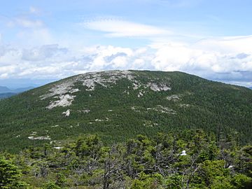
East Baldpate as seen from West Baldpate.
|
|
| Highest point | |
| Elevation | 3780+ feet (1152+ m) NGVD 29 |
| Prominence | 2,220 ft (680 m) |
| Listing | New England Fifty Finest #28 New England 100 Highest #95 |
| Geography | |
| Parent range | Mahoosuc Range |
| Topo map | USGS Old Speck Mountain |
| Climbing | |
| Easiest route | Appalachian Trail |
Baldpate Mountain is a cool mountain located in Oxford County, Maine, USA. It has two main tops, called peaks. The West Peak is about 3,662 feet (1,116 meters) high. It stands taller than the dip between the two peaks.
Where is Baldpate Mountain?
Baldpate Mountain is surrounded by other mountains. To its north is Surplus Mountain. Black Mountain is to the northeast, and Mount Hittie is to the southeast.
To the southwest, Baldpate Mountain faces Old Speck Mountain. This is across a place called Grafton Notch. This notch is like a natural border for the Mahoosuc Range.
Water Flow from Baldpate
Water that falls on Baldpate Mountain eventually flows into the Androscoggin River. This river then goes into Merrymeeting Bay, which is where the Kennebec River meets the ocean. Finally, the water reaches the Gulf of Maine.
- Water from the northwest side of Baldpate flows into the Swift Cambridge River. This then goes into the Dead Cambridge River and Umbagog Lake. Umbagog Lake is actually where the Androscoggin River starts!
- Water from the southeast and southwest sides flows into the Bear River. This river also joins the Androscoggin.
- Water from the northeast side flows into the Ellis River, which then connects to the Androscoggin River too.
The Appalachian Trail
A very famous hiking path called the Appalachian Trail goes right over Baldpate Mountain! This trail is super long, about 2,170 miles (3,492 km). It stretches all the way from Georgia to Maine. Hikers on this trail walk over both of Baldpate's peaks. The trail runs from Grafton Notch to Surplus Mountain.
 | Janet Taylor Pickett |
 | Synthia Saint James |
 | Howardena Pindell |
 | Faith Ringgold |


