
Banshee Peak facts for kids
Quick facts for kids Banshee Peak |
|
|---|---|

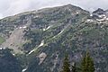
Banshee Peak seen from Sunrise area
|
|
| Highest point | |
| Elevation | 7,400 ft (2,300 m) |
| Prominence | 360 ft (110 m) |
| Geography | |

Banshee Peak
Location in Washington (state)

Banshee Peak
Location in the United States
|
|
| Location | Mount Rainier National Park Pierce County, Washington, U.S. |
| Parent range | Cascades |
| Topo map | USGS Chinook Pass |
| Climbing | |
| Easiest route | Scrambling class 2 |
Banshee Peak is a tall mountain peak, over 7,400 feet high. It is located in Mount Rainier National Park in Washington state, USA. This peak is part of the Cascade Range, a large mountain chain.
Banshee Peak sits between the Cowlitz Chimneys and Panhandle Gap. The Sarvant Glacier, a large ice mass, is found below its north side. The mountain itself is made from old layers of lava rock. You can reach the peak from Panhandle Gap by following the Wonderland Trail. The top of Banshee Peak has a special type of land called alpine tundra. This means it's a treeless area with small plants, similar to what you see on Burroughs Mountain. If the weather is clear, you can see Banshee Peak from the Sunrise Historic District. The road to Sunrise is only open in the summer because of deep snowpack during other seasons.
Contents
Weather at Banshee Peak
Banshee Peak is in a special climate zone called the marine west coast. This means it gets a lot of moisture from the Pacific Ocean.
How Mountains Get Rain and Snow
Most weather systems start over the Pacific Ocean. They travel northeast towards the Cascade Mountains. When these weather systems hit the tall mountains, they are forced to rise. As the air goes up, it cools down and drops its moisture. This moisture falls as rain or snow on the mountains. This process is called Orographic lift. Because of this, the western side of the Cascades gets a lot of rain and snow, especially in winter.
Winter and Summer Weather
In winter, the weather is usually cloudy. But in summer, high-pressure systems over the Pacific Ocean often bring clear skies. The snow in this area tends to be wet and heavy because of the ocean's influence. This kind of snow can lead to a high risk of avalanches. Water from Banshee Peak flows into streams that feed the White River and the Cowlitz River.
Images for kids
-
Banshee Peak, seen from the south side.
-
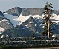
Banshee Peak as viewed from Sunrise Point.


More Information
- You can learn more about the park on the National Park Service website: Mount Rainier National Park
