Bayard, New Mexico facts for kids
Quick facts for kids
Bayard, New Mexico
|
|
|---|---|
| Motto(s):
"Hub of the Mining District"
|
|

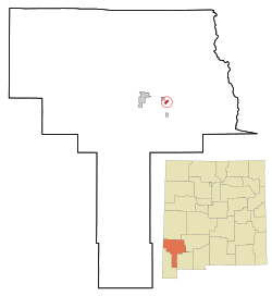
Location of Bayard, New Mexico
|
|
| Country | United States |
| State | New Mexico |
| County | Grant |
| Government | |
| • Type | Mayor–council government |
| Area | |
| • Total | 0.95 sq mi (2.47 km2) |
| • Land | 0.95 sq mi (2.46 km2) |
| • Water | 0.00 sq mi (0.01 km2) |
| Elevation | 5,807 ft (1,770 m) |
| Population
(2020)
|
|
| • Total | 2,116 |
| • Density | 2,225.03/sq mi (859.36/km2) |
| Time zone | UTC-7 (Mountain (MST)) |
| • Summer (DST) | UTC-6 (MDT) |
| ZIP code |
88023
|
| Area code(s) | 575 |
| FIPS code | 35-06270 |
| GNIS feature ID | 2409799 |
Bayard is a city in Grant County, New Mexico, in the United States. It is located close to Santa Rita and east of Silver City. In 2020, about 2,116 people lived there. The city was officially started on August 20, 1938.
Contents
Exploring Bayard's Location
Bayard is found in the eastern-central part of Grant County. The city covers about 2.45 square kilometers (about 0.95 square miles) of land. It sits in a valley near Whitewater Creek. This creek flows south and eventually joins the Mimbres River.
Main Roads and Travel
U.S. Route 180 goes right through Bayard. It is known as Tom Foy Boulevard and Central Avenue in the city. This main road can take you northwest to nearby towns like Santa Clara (about 2 miles away) and Silver City (about 9 miles away). If you head south on Route 180, you can reach Deming (about 42 miles away) and Interstate 10.
Another important road, New Mexico State Road 356, starts in Bayard. It goes northeast for about 5 miles, following the Whitewater Creek valley to Hanover.
Natural Surroundings
Bayard is located in the southern part of the Pinos Altos Range. These are mountains that are part of the larger Mogollon Mountains. The city is also east of the Continental Divide, which is a line that separates rivers flowing to different oceans. Bayard is quite high up, at about 5,800 feet (1,768 meters) above sea level.
North of Bayard, you'll find the Gila National Forest. This is a large forest area. To the south, the land changes to a semi-arid desert. This means it's a dry area, mostly covered with grasses and yucca plants.
Bayard's Population Over Time
| Historical population | |||
|---|---|---|---|
| Census | Pop. | %± | |
| 1940 | 764 | — | |
| 1950 | 2,119 | 177.4% | |
| 1960 | 2,327 | 9.8% | |
| 1970 | 2,908 | 25.0% | |
| 1980 | 3,036 | 4.4% | |
| 1990 | 2,598 | −14.4% | |
| 2000 | 2,534 | −2.5% | |
| 2010 | 2,328 | −8.1% | |
| 2020 | 2,116 | −9.1% | |
| U.S. Decennial Census | |||
The population of Bayard has changed over the years. The census is a count of all the people living in an area. In 2000, there were 2,534 people living in Bayard. By 2010, the population had gone down a bit to 2,328 people. The most recent count in 2020 showed 2,116 residents.
Who Lives in Bayard?
In 2000, there were 970 households in Bayard. A household is a group of people living together in one home. About 34% of these households had children under 18 living with them. The average household had about 2.6 people.
The people living in Bayard come from many different backgrounds. Many residents are of Hispanic or Latino heritage.
The population also includes people of different ages. In 2000, about 29% of the population was under 18 years old. About 17% of the people were 65 years or older. The median age was 37 years. This means half the people were younger than 37 and half were older.
See also
 In Spanish: Bayard (Nuevo México) para niños
 | Bessie Coleman |
 | Spann Watson |
 | Jill E. Brown |
 | Sherman W. White |


