
Bears Breast Mountain facts for kids
Quick facts for kids Bears Breast Mountain |
|
|---|---|

Bears Breast Mountain
|
|
| Highest point | |
| Elevation | 7,197 ft (2,194 m) |
| Prominence | 1,117 ft (340 m) |
| Geography | |

Bears Breast Mountain
Location in Washington (state)

Bears Breast Mountain
Location in the United States
|
|
| Parent range | Cascade Range |
| Topo map | USGS Mount Daniel |
| Type of rock | Swauk Formation sandstone |
| Climbing | |
| First ascent | August 8, 1939 by Fred Beckey, Joe Barto, Wayne Swift |
| Easiest route | Southwest Face class 5.4 |
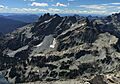
Bears Breast Mountain is a mountain peak in Washington state, USA. It stands about 7,197 feet (2,194 meters) tall. This mountain is found in Kittitas County.
Bears Breast Mountain is completely inside the Alpine Lakes Wilderness. This area is managed by the Wenatchee National Forest. The mountain is just east of the main Cascade Range mountains. It is about ten miles northeast of Snoqualmie Pass. You cannot see the mountain from a main road. However, you can see it from a hiking trail. This trail goes southwest of the peak, near Dutch Miller Gap. Rain and snowmelt from the mountain flow into rivers. These rivers then join the Waptus River. The closest taller mountain is Little Big Chief Mountain. It is about 1.62 miles (2.61 km) to the southwest.
Mountain Weather
Bears Breast Mountain is in a special climate zone. This zone is called the marine west coast climate. It is found in western North America. Most weather systems here start over the Pacific Ocean. They then move northeast towards the Cascade Range.
As these weather systems reach the Cascade Mountains, the peaks force the air upwards. This process is called Orographic lift. When the air rises, it cools down. This causes the moisture in the air to turn into rain or snow. So, the western side of the Cascades gets a lot of rain and snow. This is especially true during the winter months.
In winter, the weather is often cloudy. But in summer, high-pressure systems form over the Pacific Ocean. These systems often bring clear skies. Because the ocean affects the weather, the snow here is often wet and heavy. This can create a risk of avalanches.
How the Mountains Formed
The Alpine Lakes Wilderness has very rugged land. It features sharp peaks and long ridges. There are also deep glacial valleys and tall granite walls. Over 700 mountain lakes dot the landscape.
Long ago, huge geological events shaped the land. These events created the varied landscape of the Cascade Range. They also caused big changes in elevation. These elevation changes lead to different climates. Different climates then create different types of plants.
The Cascade Mountains began to form millions of years ago. This was during the late Eocene Epoch. The North American Plate was slowly moving over the Pacific Plate. This movement caused many volcanic eruptions. Also, small pieces of the Earth's crust, called terranes, joined together. This helped form the North Cascades about 50 million years ago.
During the Pleistocene period, about two million years ago, glaciers were very active. These huge ice sheets moved across the land many times. They carved out the landscape. They also left behind piles of rock and debris. The last glaciers in the Alpine Lakes area started to melt about 14,000 years ago. They had moved north of the Canada–US border by 10,000 years ago. The river valleys here have a U-shape. This shape was created by these recent glaciers.
The lifting of the land and faults, combined with glaciers, have been the main forces. They created the tall peaks and deep valleys you see today in the Alpine Lakes Wilderness.
Images for kids
-
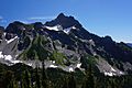
Bears Breast Mountain from Mount Hinman
-
Bears Breast from northwest


