Beaver Run (Little Muncy Creek tributary) facts for kids
Quick facts for kids Beaver Run |
|
|---|---|

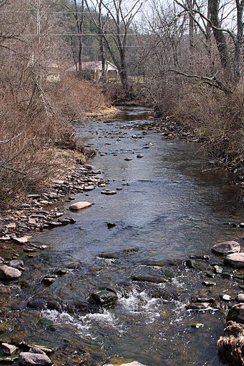
Beaver Run looking upstream
|
|
| Other name(s) | Beaver Dam Run |
| Physical characteristics | |
| Main source | North Mountain region in Davidson Township, Sullivan County, Pennsylvania 2,261 ft (689 m) |
| River mouth | Little Muncy Creek in Franklin Township, Sullivan County, Pennsylvania near Lairdsville\ 761 ft (232 m) 41°14′24″N 76°36′12″W / 41.2400°N 76.6032°W |
| Length | 7.9 mi (12.7 km) |
| Basin features | |
| Progression | Little Muncy Creek → Muncy Creek → West Branch Susquehanna River → Susquehanna River → Chesapeake Bay |
| Basin size | 12.7 sq mi (33 km2) |
| Tributaries |
|
Beaver Run (also known as Beaver Dam Run) is a stream in Pennsylvania. It flows into Little Muncy Creek. This stream is about 7.9 miles (12.7 km) long.
Beaver Run flows through Sullivan County and Lycoming County. A lake called Beaver Lake is located on the stream. Beaver Run also has one main branch, which is called Marsh Run.
Contents
Where Beaver Run Flows
Beaver Run starts in the North Mountain area. This is in Davidson Township, Sullivan County. It flows mostly west and then south. Along its path, it crosses Pennsylvania Route 42.
The stream then goes through some wetlands and ponds. After that, it enters Beaver Lake. Most of Beaver Lake is in Lycoming County. From the lake, Beaver Run continues flowing south.
Further downstream, Beaver Run meets its only named branch, Marsh Run. Finally, Beaver Run joins Little Muncy Creek. This meeting point is about 14.90 miles (24.0 km) upstream from the mouth of Little Muncy Creek.
Marsh Run: A Branch of Beaver Run
Beaver Run has one named branch called Marsh Run. Marsh Run flows into Beaver Run about 2.38 miles (3.83 km) before Beaver Run joins Little Muncy Creek. The area that Marsh Run drains is about 3.80 square miles (9.8 km2).
Land and Water Around Beaver Run
The land around the start of Beaver Run is quite high. It is about 2,261 feet (689 m) above sea level. Where Beaver Run ends, it is lower, about 761 feet (232 m) above sea level.
Beaver Lake is a notable feature on the stream. This lake covers about 73 acres (30 ha). Most of Beaver Lake is in Lycoming County.
Rocks and Glaciers
The ground near Beaver Run has different types of soil and rocks. You can find sand and gravel along the stream's valley. There are also areas with alluvium, which is soil deposited by water.
The bedrock in the area is made of sandstone and shale. These are common types of rock. Long ago, during the Wisconsinan Glaciation (an Ice Age), glaciers moved through this valley. These glaciers helped shape the valley, making it deeper.
Water Quality and Dams
The total area that drains into Beaver Run is about 12.7 square miles (32.9 km2). The stream's mouth is near Lairdsville.
There is a dam on Beaver Run called the Beaver Lake Dam. This dam is made of earth and has a concrete wall. It is about 9 feet (2.7 m) high and 179 feet (55 m) long. The dam helps control the water flow.
Some parts of Beaver Run and its smaller branches are considered "impaired." This means the water quality is not as good as it could be. This issue is often linked to farming activities in the area.
History of Beaver Run
Beaver Run has been officially recognized since 1979. Its other name, Beaver Dam Run, was mentioned in a book from 1880.
In the past, there were places where copper was processed along Beaver Run. In the early 1800s, the stream was even considered a public highway up to these copper works.
Over the years, several bridges have been built over Beaver Run.
- A concrete bridge for T-708 was built in 1920. It is 33.1 feet (10.1 m) long.
- Another concrete bridge for T-706 was also built in 1920. It is 27.9 feet (8.5 m) long.
- A steel bridge for State Route 2061 was built in 1939. It is 41.0 feet (12.5 m) long.
- A modern bridge for State Route 2077 was built in 1985. It is 48.9 feet (14.9 m) long.
 | Tommie Smith |
 | Simone Manuel |
 | Shani Davis |
 | Simone Biles |
 | Alice Coachman |


