Beinn a' Chaorainn (Glen Spean) facts for kids
Quick facts for kids Beinn a’ Chaorainn |
|
|---|---|

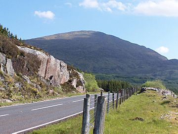
The southern flank of the mountain seen from Roughburn on the A86.
|
|
| Highest point | |
| Elevation | 1,049.1 m (3,442 ft) |
| Prominence | 228 m (748 ft) |
| Parent peak | Creag Meagaidh |
| Listing | Munro, Marilyn |
| Naming | |
| English translation | Mountain of the Rowan Tree |
| Language of name | Gaelic |
| Geography | |
|
Lua error in Module:Location_map at line 420: attempt to index field 'wikibase' (a nil value).
|
|
| Parent range | Grampians |
| OS grid | NN386850 |
| Topo map | OS Landranger 34, OS Explorer 401 |
| Listed summits of Beinn a' Chaorainn (Glen Spean) | ||||
| Name | Grid ref | Height | Status | |
|---|---|---|---|---|
| Beinn a’ Chaorainn South Top | NN386845 | 1049 m (3441 ft) | Munro Top | |
| Beinn a’ Chaorainn North Top | NN383857 | 1044 m (3425 ft) | Munro Top | |

Beinn a’ Chaorainn is a tall Scottish mountain. It is found in the Lochaber area of the Highland region. This mountain is about 30 kilometers east of Fort William. There are other mountains with the same name in the Scottish Highlands. So, make sure not to confuse it with the one in the Cairngorms.
Contents
About Beinn a’ Chaorainn
Beinn a’ Chaorainn stands 1052 meters (3451 feet) high. This makes it a Munro, which is a Scottish mountain over 3,000 feet. It is also a Marilyn, meaning it has a certain height above its surrounding land.
This mountain is part of the Grampian Mountains. People often call this area the Loch Laggan Hills. Nearby mountains include the Creag Meagaidh range and Beinn Teallach. Many hikers climb Beinn a’ Chaorainn and Beinn Teallach together. They do a 13-kilometer walk around the Allt a’ Chaorainn valley. This popular route starts at Roughburn on the A86 road. The name "Beinn a’ Chaorainn" comes from the Gaelic language. It means "Mountain of the Rowan Tree."
Mountain Shape and Views
Beinn a’ Chaorainn is shaped like a long ridge that runs north to south. From Roughburn, it might look like a simple, large hill. But from the east, it looks more interesting. Here, you can see the rocky cliffs of Coire na h-Uamha. A "coire" is a bowl-shaped valley formed by glaciers.
Coire na h-Uamha
The name Coire na h-Uamha means "Corrie of the Cave." Even though it's called that, no big caves are known here. But there are a few small lochans (small lakes) high up in the corrie. Water from this corrie flows into the Allt na h-Uamha stream. This stream's valley separates Beinn a’ Chaorainn from the Creag Meagaidh mountains to the east. Some parts of the eastern side of the mountain are covered with conifer trees. These trees grow below 550 meters.
There's a ridge that splits Coire na h-Uamha into two parts. You can climb this ridge to reach the main summit. However, you need to be careful, especially in winter. In winter, this route is considered a Grade I climb.
Other Corries and Ridges
At the northern end of the mountain is Coire Buidhe, which means "Yellow Corrie." Water from this corrie flows into the Burn of Algie, which is part of the River Roy. Two ridges lead down from this corrie to connect with other Munros. One ridge goes northwest to Beinn Teallach. It connects at a low point (a col) that is 614 meters high. The other ridge goes northeast to the Bealach a’ Bharnish (824 meters). From there, you can climb onto the Creag Meagaidh plateau.
The southern side of Beinn a’ Chaorainn slopes down to Glen Spean. Here, you'll find more conifer tree plantations below 400 meters. The western sides of the mountain are very steep. They drop down to the valley of the Allt a’ Chaorainn stream. All the water from the mountain eventually flows to the west coast of Scotland. It travels through the River Spean, either directly from Glen Spean or by way of Glen Roy.
The Summit Ridge
The top ridge of Beinn a’ Chaorainn is about 1.5 kilometers long. It has three high points. The middle point is now considered the highest summit. For a long time, the South Top (1049 meters) was thought to be the highest. But in 1974, new surveys showed the middle point was taller. The North Top (1044 meters) has always been known as a "Top" in the Munro tables.
The summit ridge can be tricky for hikers in winter. This is because parts of the eastern corrie cut deeply into the ridge. In winter, snow can build up and form dangerous overhangs called cornices. Hikers using a compass to go between the high points might accidentally walk onto these cornices. It is important to be very careful and know where these hidden dangers are.
How to Climb Beinn a’ Chaorainn
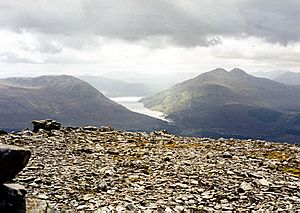
The most common way to climb Beinn a’ Chaorainn starts at Roughburn on the A86 road. You can find parking near the Loch Laggan Dam, about 700 meters southwest. From there, you follow forest roads and paths through the trees. You will come out onto the open hillside at about 400 meters high. The path then goes northeast up a wide ridge. This ridge is on the west side of a shallow corrie called Coire Clachaig. From the top of Beinn a’ Chaorainn, you get amazing views of the Munros around Loch Treig.
 | Misty Copeland |
 | Raven Wilkinson |
 | Debra Austin |
 | Aesha Ash |

