Beinn a' Chuallaich facts for kids
Quick facts for kids Beinn a’ Chuallaich |
|
|---|---|

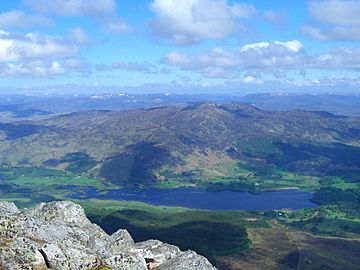
Seen across Dunalastair Water from Schiehallion, 7 km to the SE.
|
|
| Highest point | |
| Elevation | 892 m (2,927 ft) |
| Prominence | 527 m (1,729 ft) |
| Listing | Corbett, Marilyn |
| Naming | |
| English translation | Hill of the Herding |
| Language of name | Gaelic |
| Geography | |
|
Lua error in Module:Location_map at line 420: attempt to index field 'wikibase' (a nil value).
|
|
| Parent range | Grampians |
| OS grid | NN684617 |
| Topo map | OS Landranger 42, OS Explorer 386 |
Beinn a’ Chuallaich is a Scottish hill located in Perth and Kinross. It stands about four kilometres northeast of the village of Kinloch Rannoch. This mountain is part of the high ground found between Strath Tummel and Glen Errochty.
Contents
Discovering Beinn a’ Chuallaich
Beinn a’ Chuallaich is a large and sprawling hill. Sometimes, it can be hard to spot from certain angles. This is especially true from the south. That's because the more famous and taller Schiehallion mountain is nearby. Schiehallion is about seven kilometres to the southeast. It stands across Dunalastair Water and dominates the area called Strath Tummel.
However, Beinn a’ Chuallaich looks impressive from the top of Glen Errochty. From there, you can clearly see its long northeast ridge. You can also see its rocky eastern corrie, which is like a bowl-shaped valley. The hill reaches a height of 892 metres (2926 feet). It is known as a Corbett and a Marilyn. These are special lists of hills in the British Isles.
What Does the Name Mean?
The name Beinn a’ Chuallaich comes from the Scottish Gaelic language. It means “Hill of the Herding.” This name tells us something important about the hill's past. It was located on one of Scotland's main ancient drovers' roads. These were routes used to move cattle from one place to another.
The area around the mountain was a meeting point for cattle. The western corrie of the hill was likely used for gathering them. It's a huge, gentle bowl perfect for summer grazing. It was also a good place to hide cattle. Old maps from the 1700s and 1800s show the hill with slightly different names. But by the late 1800s, it was officially called Beinn a’ Chuallaich.
Exploring the Mountain's Shape
Beinn a’ Chuallaich is a large mountain that stands over Kinloch Rannoch village. It has several long ridges and two important corries. A ridge is a long, narrow hilltop. A corrie is a deep, rounded hollow on a mountainside.
Northern Ridges and Lochs
The longest ridge goes north and then northeast. It includes a smaller peak called Meall nan Eun, which is 852 metres high. This ridge then widens and goes down to the shores of Loch Errochty. At the top of Meall nan Eun, you'll find a ring of stones. From here, you get a great view of Loch Errochty. This loch cannot be seen from the main summit.
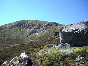
Loch na Caillich is another small loch on this northeast ridge. It sits at about 700 metres high. This loch is a well-known spot where deer gather. Coire Odhar is on the eastern side of the hill. It has cliffs that drop from the summit. This corrie also contains some very large, loose boulders.
Western and Southern Features
The western corrie is called Coire Labhrainn. Water from this corrie flows into the Allt Mòr. This stream is amazing to see after heavy rain. It rushes through the woods above Kinloch Rannoch. Then it flows through the village to join the River Tummel. All the water from the mountain eventually flows into the River Tay. Some streams on the eastern side of the hill have been redirected. They are now part of the Tummel hydro-electric power scheme. This scheme uses water to make electricity.
The three southern ridges are quite steep. They drop down to the valley of the River Tummel. One ridge goes west and then south. It includes the rocky slopes of Càrn Fiaclach. Another ridge goes southeast, descending to Drumglas. Drumglas is on the shores of Dunalistair Water. This ridge has the crags of Creag Buidhe on its lower parts.
The third southern ridge goes southwest. It is the most interesting of the three. It ends in a steep and amazing crag. This crag drops down to the B846 road, just east of Kinloch Rannoch. The crag is called Craig Varr. It is an example of a truncated spur. This means it was formed when a huge glacier sliced through the ridge. This happened about 10,000 years ago, during the Earth's last ice age. The glacier left behind steep, south-facing cliffs.
Rock Climbing at Craig Varr
The cliffs of Craig Varr are a popular place for rock climbers. They are easy to reach from the road and parking spots. These schist cliffs are about 100 metres high. They offer around 30 climbing routes. These routes are 30 to 50 metres long. Their difficulty ranges from Very Difficult to Very Severe. The crags face south, which makes them even more popular. This means they dry quickly and get lots of sunshine.
Climbing to the Summit
People usually climb Beinn a’ Chuallaich from the south or the east. From the south, you can start from Kinloch Rannoch or Drumglas. The route from Kinloch Rannoch goes up the Allt Mòr. You'll pass a beautiful waterfall before climbing steeply to the summit ridge. The route from Drumglas is the most direct. It uses the southeast ridge.
An approach from the east starts from the B847 road. You'll pass a bothy (a simple shelter) and a deer fence. Then you climb steeply up Coire Odhar to reach the summit.
Summit Views
Beinn a’ Chuallaich offers fantastic views. It has a topographic prominence of 527 metres. This means it rises very high above the land around it. It is the highest point for a long distance. Only Schiehallion, over seven kilometres to the southeast, blocks the distant view. From the top, you can see a great full-length view of Loch Rannoch. You can also see the Ben Alder mountain range to the northwest.
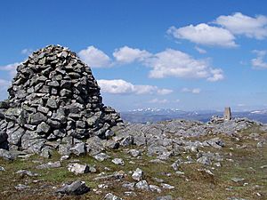
The highest point of the hill has an Ordnance Survey trig point. This is a marker used for mapping. But the most impressive feature on the summit is a three-metre-high cairn. A cairn is a pile of stones. This one is built from quartzite boulders. It stands 20 metres southeast of the trig point.
 | John T. Biggers |
 | Thomas Blackshear |
 | Mark Bradford |
 | Beverly Buchanan |


