Bellmawr, New Jersey facts for kids
Quick facts for kids
Bellmawr, New Jersey
|
||
|---|---|---|
|
Borough
|
||
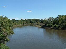
Big Timber Creek in Bellmawr
|
||
|
||
| Motto(s):
Progress Never Stops
|
||
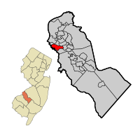
Location of Bellmawr in Camden County highlighted in red (right). Inset map: Location of Camden County in New Jersey highlighted in orange (left).
|
||
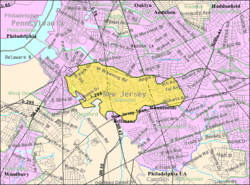
Census Bureau map of Bellmawr, New Jersey
|
||
| Country | ||
| State | ||
| County | Camden | |
| Incorporated | April 21, 1926 | |
| Named for | Ernest C. Bell | |
| Government | ||
| • Type | Borough | |
| • Body | Borough Council | |
| Area | ||
| • Total | 3.11 sq mi (8.05 km2) | |
| • Land | 2.98 sq mi (7.73 km2) | |
| • Water | 0.12 sq mi (0.32 km2) 3.92% | |
| Area rank | 329nd of 565 in state 12th of 37 in county |
|
| Elevation | 66 ft (20 m) | |
| Population
(2020)
|
||
| • Total | 11,707 | |
| • Estimate
(2023)
|
11,724 | |
| • Rank | 216th of 565 in state 11th of 37 in county |
|
| • Density | 3,923.3/sq mi (1,514.8/km2) | |
| • Density rank | 168th of 565 in state 21st of 37 in county |
|
| Time zone | UTC−05:00 (Eastern (EST)) | |
| • Summer (DST) | UTC−04:00 (Eastern (EDT)) | |
| ZIP Codes |
08031, 08099
|
|
| Area code(s) | 856 | |
| FIPS code | 3400704750 | |
| GNIS feature ID | 0885154 | |
Bellmawr is a small town, called a borough, located in Camden County, New Jersey. In 2020, about 11,707 people lived here.
Bellmawr is also home to a very large post office. It's one of the biggest in New Jersey! This post office handles millions of pieces of mail every single day.
Contents
About Bellmawr
The History of Bellmawr
Bellmawr became an official borough on April 21, 1926. It was created from parts of another area called Centre Township. Several other nearby towns, like Mount Ephraim and Runnemede, were also formed around the same time.
The town was named after Ernest C. Bell. He used to own a farm in the area.
Where is Bellmawr Located?
Bellmawr covers about 3.11 square miles (8.05 square kilometers) of land. Most of this area is land, with a small part being water.
The borough shares its borders with several other towns. These include Barrington, Brooklawn, and Gloucester City in Camden County. It also borders Deptford Township and Westville in Gloucester County.
How Many People Live in Bellmawr?
| Historical population | |||
|---|---|---|---|
| Census | Pop. | %± | |
| 1930 | 1,123 | — | |
| 1940 | 1,250 | 11.3% | |
| 1950 | 5,213 | 317.0% | |
| 1960 | 11,853 | 127.4% | |
| 1970 | 15,618 | 31.8% | |
| 1980 | 13,721 | −12.1% | |
| 1990 | 12,603 | −8.1% | |
| 2000 | 11,262 | −10.6% | |
| 2010 | 11,583 | 2.9% | |
| 2020 | 11,707 | 1.1% | |
| 2023 (est.) | 11,724 | 1.2% | |
| Population sources:1930–2000 1930 1940–2000 2000 2010 2020 |
|||
In 2010, there were 11,583 people living in Bellmawr. There were 4,670 households, which are groups of people living together. The average household had about 2.48 people.
The population included people of different ages. About 20% were under 18 years old. Around 17% were 65 years or older. The average age in Bellmawr was about 41 years old.
Education in Bellmawr
Bellmawr Public Schools
The Bellmawr School District serves students from pre-kindergarten up to eighth grade. The district has three schools:
- Bellmawr Park Elementary School (Pre-K to 4th grade)
- Ethel M. Burke Elementary School (Kindergarten to 4th grade)
- Bell Oaks Upper Elementary School (5th to 8th grade)
High School Education
After eighth grade, students from Bellmawr attend Triton Regional High School. This high school is located in the nearby town of Runnemede.
Triton Regional High School is part of the Black Horse Pike Regional School District. This district also includes students from Gloucester Township and Runnemede.
Technical and Vocational Schools
Students in Bellmawr can also choose to attend the Camden County Technical Schools. These schools offer special training for jobs and careers. They have two campuses:
- Gloucester Township Technical High School
- Pennsauken Technical High School
These schools help students learn skills for different jobs. The cost of attending and transportation is covered by their home school district.
Getting Around Bellmawr
Roads and Highways
Bellmawr has many roads, including major highways. The New Jersey Turnpike passes through the southern part of the town. Part of its Exit 3 is located in Bellmawr.
Other important roads include Route 42 and Interstate 295. These highways connect Bellmawr to other parts of New Jersey and beyond. Route 168 and a small part of U.S. Route 130 also go through the borough.
Public Transportation
If you need to travel without a car, NJ Transit offers bus service in Bellmawr. The 400 bus route connects Bellmawr to Sicklerville and Philadelphia.
Notable People from Bellmawr
Many interesting people have connections to Bellmawr. Here are a few:
- Rob Andrews (born 1957): He was a congressman who represented New Jersey for 24 years.
- Walter Rand (1919–1995): A politician who worked on transportation issues in New Jersey.
- Joseph J. Roberts (born 1952): He was a politician who served in the New Jersey General Assembly.
- Buddy Robinson (born 1991): A professional ice hockey player.
- Eric Robinson (born 1995): Another professional ice hockey player, who plays for the Buffalo Sabres.
Images for kids
See also
 In Spanish: Bellmawr para niños
 | James Van Der Zee |
 | Alma Thomas |
 | Ellis Wilson |
 | Margaret Taylor-Burroughs |


