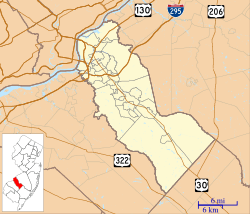
Barrington, New Jersey facts for kids
Quick facts for kids
Barrington, New Jersey
|
||
|---|---|---|
|
Borough
|
||
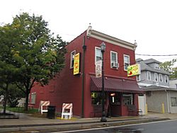
Clements Bridge Road
|
||
|
||
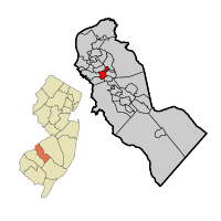
Location of Barrington in Camden County highlighted in red (right). Inset map: Location of Camden County in New Jersey highlighted in orange (left).
|
||
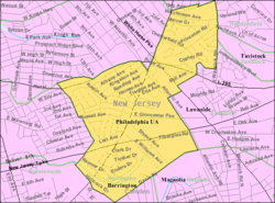
Census Bureau map of Barrington, New Jersey
|
||
| Country | ||
| State | ||
| County | Camden | |
| Incorporated | April 17, 1917 | |
| Named for | Great Barrington, Massachusetts | |
| Government | ||
| • Type | Borough | |
| • Body | Borough Council | |
| Area | ||
| • Total | 1.58 sq mi (4.10 km2) | |
| • Land | 1.58 sq mi (4.10 km2) | |
| • Water | 0.00 sq mi (0.00 km2) 0.00% | |
| Area rank | 443rd of 565 in state 21st of 37 in county |
|
| Elevation | 79 ft (24 m) | |
| Population
(2020)
|
||
| • Total | 7,075 | |
| • Estimate
(2023)
|
7,069 | |
| • Rank | 316th of 565 in state 19th of 37 in county |
|
| • Density | 4,475.0/sq mi (1,727.8/km2) | |
| • Density rank | 135th of 565 in state 14th of 37 in county |
|
| Time zone | UTC−05:00 (Eastern (EST)) | |
| • Summer (DST) | UTC−04:00 (Eastern (EDT)) | |
| ZIP Code |
08007
|
|
| Area code(s) | 856 | |
| FIPS code | 3400703250 | |
| GNIS feature ID | 0885149 | |
| Website | ||
Barrington is a small town, called a borough, in Camden County, New Jersey. In 2020, about 7,075 people lived there.
The area got its name in the 1880s from William Simpson. He was one of the people who helped develop the area. He named it after his home in Great Barrington, Massachusetts.
Barrington officially became a borough on March 27, 1917. This happened after people voted for it on April 17, 1917. Later, in 1926, a part of Barrington was used to create the town of Lawnside.
Contents
Where is Barrington Located?
Barrington is a small place, covering about 1.58 square miles (4.10 square kilometers) of land. It doesn't have any water areas.
It shares borders with several other towns in Camden County. These include Bellmawr, Haddon Heights, Haddonfield, Lawnside, Magnolia, Runnemede, and Tavistock.
How Many People Live in Barrington?
| Historical population | |||
|---|---|---|---|
| Census | Pop. | %± | |
| 1920 | 1,333 | — | |
| 1930 | 2,252 | * | 68.9% |
| 1940 | 2,329 | 3.4% | |
| 1950 | 2,651 | 13.8% | |
| 1960 | 7,943 | 199.6% | |
| 1970 | 8,409 | 5.9% | |
| 1980 | 7,418 | −11.8% | |
| 1990 | 6,774 | −8.7% | |
| 2000 | 7,050 | 4.1% | |
| 2010 | 6,983 | −1.0% | |
| 2020 | 7,075 | 1.3% | |
| 2023 (est.) | 7,069 | 1.2% | |
| Population sources: 1920–2000 1920 1920–1930 1940–2000 2000 2010 2020 * = Lost territory in previous decade. |
|||
In 2010, about 6,983 people lived in Barrington. There were almost 3,000 households. The population density was about 4,346 people per square mile.
About 20.8% of the people were under 18 years old. Around 15.8% were 65 years or older. The average age in Barrington was 40.7 years.
What Businesses are in Barrington?
Edmund Scientific Corporation used to be based in Barrington since 1942. Their store opened in 1952 but closed in 2001.
Barrington is also home to a factory that makes boxes for International Paper.
Schools in Barrington
The Barrington Public Schools serve students from kindergarten through eighth grade. The school district has two schools. In the 2020-2021 school year, there were 567 students and 60.8 teachers. This means there were about 9.3 students for every teacher.
- Avon Elementary School teaches students from Pre-K to 4th grade.
- Woodland Middle School teaches students from 5th to 8th grade.
For high school, students attend Haddon Heights Junior/Senior High School. This school is in Haddon Heights. Students from Barrington, Lawnside, and Merchantville all go to this high school. In 2020-2021, the high school had 997 students.
Students in Camden County can also attend the Camden County Technical Schools. These schools offer special training for jobs and careers. They have two locations: Gloucester Township Technical High School and Pennsauken Technical High School.
St. Francis De Sales Regional School was a Catholic elementary school in Barrington. It closed after the 2008-2009 school year. This was because fewer students were enrolling and costs were rising.
Getting Around Barrington
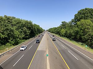
Barrington has about 25.57 miles of roads. Most of these roads are maintained by the town itself.
The New Jersey Turnpike is a major highway that goes through Barrington for about 1 mile. It connects Barrington to nearby towns like Bellmawr and Lawnside. The closest exit for the Turnpike is in Bellmawr or Runnemede.
Interstate 295 also passes through Barrington briefly. Exit 29 connects it to U.S. Route 30 and Route 41.
Public Transportation
NJ Transit offers bus service in Barrington. You can take bus routes 403 and 455 to travel to other towns like Camden or Paulsboro.
The PATCO Speedline is a train system that connects Philadelphia with towns in New Jersey. The closest PATCO stations to Barrington are Haddonfield and Woodcrest.
Famous People from Barrington
Many interesting people have lived in or are connected to Barrington, New Jersey. Here are a few:
- Nilsa Cruz-Perez (born 1961), a politician who serves in the New Jersey Senate.
- Sarah Elfreth (born 1988), a politician who serves in the Maryland Senate.
- Nick Foles (born 1989), a famous quarterback who played for the Philadelphia Eagles and Jacksonville Jaguars.
- Patricia Egan Jones, a politician who served in the New Jersey General Assembly.
- Al Kenders (1937–2013), a baseball catcher who played for the Philadelphia Phillies.
- Bill Manlove (born 1933), a football coach with a great winning record.
- Charlie Manuel (born 1944), a baseball executive and former manager for the Philadelphia Phillies.
- Ernest F. Schuck (1929–2009), a politician who was mayor of Barrington and served in the New Jersey General Assembly.
- Bo Wood (born 1945), a former American football player who played for the Atlanta Falcons.
See also
 In Spanish: Barrington (Nueva Jersey) para niños
 | Ernest Everett Just |
 | Mary Jackson |
 | Emmett Chappelle |
 | Marie Maynard Daly |


