Deptford Township, New Jersey facts for kids
Quick facts for kids
Deptford Township, New Jersey
|
||
|---|---|---|
|
Township
|
||
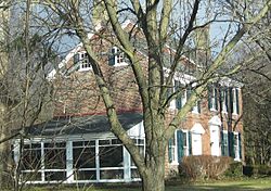
Benjamin Clark House, built in 1769, in Deptford Township, January 2010
|
||
|
||
| Nickname(s):
"First Flight in America"
|
||
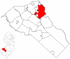
Location of Deptford Township in Gloucester County highlighted in red (right). Inset map: Location of Gloucester County in New Jersey highlighted in red (left).
|
||
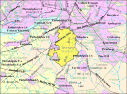
Census Bureau map of Deptford Township, New Jersey
|
||
| Country | ||
| State | ||
| County | ||
| Formed | June 1, 1695 as Bethlehem | |
| Incorporated | February 21, 1798 | |
| Named for | Deptford, England | |
| Government | ||
| • Type | Faulkner Act Council-Manager | |
| • Body | Township Council | |
| Area | ||
| • Total | 17.57 sq mi (45.50 km2) | |
| • Land | 17.33 sq mi (44.89 km2) | |
| • Water | 0.24 sq mi (0.61 km2) 1.35% | |
| Area rank | 163rd of 565 in state 9th of 24 in county |
|
| Elevation | 59 ft (18 m) | |
| Population
(2020)
|
||
| • Total | 31,977 | |
| • Estimate
(2023)
|
32,313 | |
| • Rank | 72nd of 565 in state 3rd of 24 in county |
|
| • Density | 1,845.1/sq mi (712.4/km2) | |
| • Density rank | 305th of 565 in state 11th of 24 in county |
|
| Time zone | UTC−05:00 (Eastern (EST)) | |
| • Summer (DST) | UTC−04:00 (Eastern (EDT)) | |
| ZIP Codes |
08096
|
|
| Area code | 856 | |
| FIPS code | 3401517710 | |
| GNIS feature ID | 0882149 | |
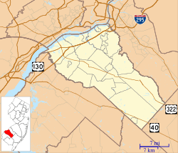
Deptford Township (pronounced DEP-ford) is a township in Gloucester County, New Jersey. It is located in the U.S. state of New Jersey. In 2020, about 31,977 people lived here. This was an increase of over 1,400 people since 2010.
Deptford Township was first created on June 1, 1695. It was originally called Bethlehem. Later, on February 21, 1798, it officially became a township. Over the years, parts of Deptford Township were used to create other nearby towns. These include Washington Township and Woodbury.
Deptford is a suburb located southeast of Philadelphia. It is near the Walt Whitman Bridge, which connects it to Philadelphia. Deptford is about 10 miles (16 km) southeast of Philadelphia. It is also about 50 miles (80 km) northwest of Atlantic City. The township was named after Deptford in London, England. This area is part of the South Jersey region.
Contents
History
Early Settlements and Growth
The first Europeans to settle in the Deptford area were from the Netherlands. They were led by explorer Cornelius Jacobsen May. After them, settlers from Sweden and Finland arrived. Eventually, the area became part of the British colonies.
Deptford Township was formed in 1695. At that time, it was much larger than it is today. It covered about 106 square miles (275 km2). This large area included what are now several other towns. Some of these are Monroe Township and West Deptford Township.
First Hot Air Balloon Landing
A very important event happened in Deptford Township. The Clement Oak is an old tree that was already growing in the 1500s. In 1793, it became the landing spot for the first hot air balloon flight in North America. A man named Jean-Pierre Blanchard flew his balloon from Philadelphia to Deptford.
During his flight, Blanchard carried a special letter. It was from George Washington, who was the President at the time. This letter was meant for the owner of the land where Blanchard landed. This made his flight the first airmail delivery in the United States!
Recent Events: Hurricane Ida Tornado
On September 1, 2021, Deptford Township was hit by a strong tornado. This tornado was an EF3, with winds up to 150 miles per hour (240 km/h). It was caused by the leftover storms from Hurricane Ida. More than 100 homes in Deptford Township were damaged by this tornado.
Geography
Location and Size
Deptford Township covers a total area of about 17.57 square miles (45.50 km2). Most of this is land, about 17.33 square miles (44.89 km2). A small part, about 0.24 square miles (0.61 km2), is water.
Neighboring Communities
Deptford Township shares borders with several other towns. In Gloucester County, it borders Mantua Township and Washington Township. It also borders Wenonah, West Deptford Township, Westville, Woodbury, and Woodbury Heights. In nearby Camden County, Deptford borders Bellmawr, Gloucester Township, and Runnemede.
Areas Within Deptford
Several smaller communities are located inside Deptford Township. One of these is Oak Valley. Other areas include Almonesson, Blackwood Terrace, and Good Intent. These are smaller neighborhoods and places within the larger township.
Population and People
| Historical population | |||
|---|---|---|---|
| Census | Pop. | %± | |
| 1800 | 2,510 | — | |
| 1810 | 2,978 | 18.6% | |
| 1820 | 3,281 | 10.2% | |
| 1830 | 3,599 | 9.7% | |
| 1840 | 2,570 | * | −28.6% |
| 1850 | 3,355 | 30.5% | |
| 1860 | 4,213 | * | 25.6% |
| 1870 | 2,698 | −36.0% | |
| 1880 | 1,520 | * | −43.7% |
| 1890 | 1,681 | * | 10.6% |
| 1900 | 2,114 | 25.8% | |
| 1910 | 2,524 | 19.4% | |
| 1920 | 2,224 | * | −11.9% |
| 1930 | 4,507 | 102.7% | |
| 1940 | 4,738 | 5.1% | |
| 1950 | 7,304 | 54.2% | |
| 1960 | 17,878 | 144.8% | |
| 1970 | 24,232 | 35.5% | |
| 1980 | 23,473 | −3.1% | |
| 1990 | 24,137 | 2.8% | |
| 2000 | 26,763 | 10.9% | |
| 2010 | 30,561 | 14.2% | |
| 2020 | 31,977 | 4.6% | |
| 2023 (est.) | 32,313 | 5.7% | |
| Population sources: 1800–2000 1800–1920 1840 1850–1870 1850 1870 1880–1890 1890–1910 1910–1930 1940–2000 2000 2010 2020 * = Lost territory in previous decade. |
|||
In 2020, Deptford Township had a population of 31,977 people. This means about 1,845 people lived in each square mile. The population has grown steadily over the years.
The people living in Deptford Township come from many different backgrounds. In 2010, about 78.8% of the people were White. About 12.2% were Black or African American. About 4.5% were Asian. People of Hispanic or Latino background made up about 6% of the population.
Economy
Deptford Mall

One of the biggest attractions in Deptford Township is the Deptford Mall. It is the largest mall in the South Jersey area. The mall has many stores and restaurants. It also has a movie theater nearby. The mall is a major place for shopping and entertainment in the area.
Parks and Recreation
Tall Pines State Preserve
Tall Pines State Preserve is a beautiful nature area in Deptford Township. It covers 111 acres (45 hectares) of land. This preserve is Gloucester County's first state park. It opened in November 2015.
The land where Tall Pines State Preserve now sits has an interesting history. It was once a forest. Then, it was used as a field for growing asparagus. Later, it became a golf course. Finally, many groups worked together to protect the land. They turned it into the peaceful park it is today.
Government
How Deptford Township is Governed
Deptford Township has a special way of running its local government. It uses a system called the Council-Manager form. This means that the township has a Township Council. The Council members are elected by the people. They serve for four years.
The Township Council has seven members. They choose a Mayor and a Deputy Mayor from among themselves. These roles last for two years. The Council also hires a Township Manager. This person is in charge of the day-to-day operations of the township. The current Township Manager is Thomas Newman Jr.
Education
Public Schools
Deptford Township has its own public school system, called Deptford Township Schools. This district has eight schools. They serve students from pre-kindergarten all the way up to twelfth grade. In the 2020–21 school year, about 3,942 students attended these schools.
The schools include:
- Central Early Childhood Center (Pre-K–1)
- Pine Acres Early Childhood Center (Pre-K–1)
- Good Intent School (grades 2–6)
- Lake Tract School (grades 2–6)
- Oak Valley School (grades 2–6)
- Shady Lane School (grades 2–6)
- Monongahela Middle School (grades 7–8)
- Deptford Township High School (grades 9–12)
There is also the Deptford Transitional Learning Academy. This school helps students aged 14 to 21. It teaches them important life and career skills.
Vocational and Private Schools
Students in Gloucester County can also apply to attend Gloucester County Institute of Technology. This high school is located in Deptford Township. It offers special technical and vocational training. Students do not have to pay tuition to attend this public school.
For students who prefer a private school, Guardian Angels Regional School is an option. It has campuses in nearby Gibbstown and Paulsboro. This school is managed by the Roman Catholic Diocese of Camden.
College Education
Rowan College of South Jersey has a campus in Deptford Township. It first opened in 1968 as Gloucester County College. It is a place where students can get a college education.
Transportation
Roads and Highways
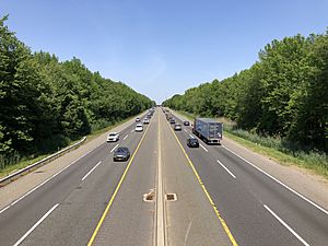
Deptford Township has many important roads. Major state routes that pass through include Route 41, Route 42, and Route 55. Several county roads also cross the township. The New Jersey Turnpike also goes through the area. A very small part of Interstate 295 is also in the township.
Public Transportation
NJ Transit provides bus service in Deptford Township. You can take a bus from Deptford to Philadelphia. There are also local bus routes that serve the township.
Notable People

Many interesting people have lived in or are connected to Deptford Township. Some of them include:
- Enrico Di Giuseppe (1932–2005), a famous opera singer.
- Evan Edinger (born 1990), a popular YouTuber.
- Joe Fields (born 1953), a former professional football player for the New York Jets and New York Giants.
- Isaac Hopper (1771–1852), an important person who helped people escape slavery through the Underground Railroad.
- Katrina Law (born around 1985), an actress.
- Patti Smith (born 1946), a famous punk rock singer, songwriter, and poet.
- Shaun T (born 1978), a well-known fitness trainer and choreographer.
- Mel Sheppard (1883–1942), an Olympic athlete who won four gold medals.
- Crystal Waters (born 1961), a singer and songwriter known for house and dance music.
See also
 In Spanish: Municipio de Deptford para niños
 | Ernest Everett Just |
 | Mary Jackson |
 | Emmett Chappelle |
 | Marie Maynard Daly |


