Belmont, Queensland facts for kids
Quick facts for kids BelmontBrisbane, Queensland |
|||||||||||||||
|---|---|---|---|---|---|---|---|---|---|---|---|---|---|---|---|

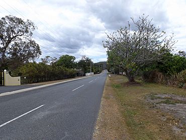
Stanbrough Road, 2014
|
|||||||||||||||
| Population | 4,498 (2021 census) | ||||||||||||||
| • Density | 449.8/km2 (1,165/sq mi) | ||||||||||||||
| Established | 1894 | ||||||||||||||
| Postcode(s) | 4153 | ||||||||||||||
| Area | 10.0 km2 (3.9 sq mi) | ||||||||||||||
| Time zone | AEST (UTC+10:00) | ||||||||||||||
| Location | 13.0 km (8 mi) ESE of Brisbane CBD | ||||||||||||||
| LGA(s) | City of Brisbane (Chandler Ward; Doboy Ward) |
||||||||||||||
| State electorate(s) | Chatsworth | ||||||||||||||
| Federal Division(s) | Bonner | ||||||||||||||
|
|||||||||||||||
Belmont is a suburb located in Brisbane, Queensland, Australia. It is found on the outer edges of the city. In 2021, about 4,498 people called Belmont home.
Contents
Exploring Belmont's Landscape
Belmont has a mix of bushland and large properties. Some areas also have modern housing estates.
Two major roads in Brisbane meet in Belmont. These are the Gateway Motorway and Old Cleveland Road. Belmont is known for its large properties, often sitting on acres of land. Homes here can be quite big, from about 325 square metres to over 929 square metres.
Mount Petrie is a hill in the southern part of Belmont. It rises to 169 metres above sea level.
A Look at Belmont's Past
Long ago, the local Aboriginal people hunted and camped in Belmont's creeks and hills. They used the area before and after European settlers arrived. There was a special gathering place (called a corroboree ground) by Bulimba Creek. Mineral springs near Mount Petrie were also a popular camping spot.
Andrew Petrie noticed that there was good timber in the area. Mount Petrie is named after him.
The suburb's name comes from Belmont House, built around 1860. Colonel August Bernecker built this house. The name "Belmont" comes from the French words Bellemont, which means beautiful mountain. August Charles Frederick Bernecker gave this name to his new estate, and it spread to the whole area.
In the 1850s, people came to Belmont to cut down Hoop Pine trees for timber. By the 1860s and 1870s, the cleared land was used for farming. Farmers grew sugar cane in the rich soil near the creeks. When sugar farming became less popular, farmers started growing pineapples, bananas, and other small crops. These included tomatoes, potatoes, and grapes. Dairy farms and farms that grew animal feed were also common.
Belmont State School first opened on 5 June 1876. Today, this school is located in the nearby suburb of Carindale. San Sisto Secondary College opened in Belmont on 1 February 1961. It is now within the boundaries of Carina.
In 1885, a company called the Grassdale Land Company Limited was formed. They bought a large property called Grassdale Paddocks. This area now covers parts of Belmont, Chandler, and Gumdale. The company sold parts of this land in an auction later that year. They advertised that the land was "only one hour's drive from Brisbane." They also said a railway would soon run through the area, making it very close to the city.
The local government area called Belmont Division was created in 1894. It was separated from the Bulimba Division. By 1901, this became the Belmont Shire. The Belmont Shire was much larger than Belmont is today. Parts of it are now in suburbs like Carindale.
From 1912 to 1925, the Belmont Shire Council ran a steam tramway. This tramway connected Norman Park railway station to a stop near the current State School. The tram line closed when Belmont Shire joined the City of Greater Brisbane. It briefly reopened in 1926.
Who Lives in Belmont?
In 2011, Belmont had 4,594 people living there. About 50.5% were female and 49.5% were male. The average age of people in Belmont was 38 years old.
Most people (72.6%) living in Belmont were born in Australia. Other common birthplaces included New Zealand (5.2%), England (2.9%), and China (1.7%). Most people (79.7%) spoke only English at home. Other languages spoken included Mandarin, Greek, and Spanish.
In 2016, Belmont's population was 4,374 people. By 2021, the population grew slightly to 4,498 people.
Learning in Belmont
There are no schools directly within Belmont's current boundaries. Even though it's called Belmont State School, it's now in Carindale.
The closest government primary schools are Tingalpa State School in Tingalpa and Gumdale State School in Gumdale. Belmont State School in Carindale is also nearby. For high school, students might go to Brisbane Bayside State College in Wynnum West. Other options include Whites Hill State College in Camp Hill or Mansfield State High School in Mansfield.
Fun Things to Do in Belmont
The Belmont Rifle Range is a place where many sport shooting clubs meet. It was used for shooting events in the 1982 Commonwealth Games and the 2018 Commonwealth Games. It also hosted the 2011 World Long Range Championships. Mount Petrie is located south of the rifle range.
Parks to Explore
Belmont has several parks where you can enjoy nature:
- Belmont Hills Bushland
- Cassandra Crescent Park
- Coventry Circuit Park
- Dairy Swamp Road Park
- Glenavon Street Park
- Iona Close Park
- Kianawah Park
- Meadowlands Picnic Ground Park
- Mt Petrie Road Park (no.386)
- Pinnacle Place Park
- She-oak Park
- Summit Street Park
- Thredbo Place Park
- Tilley Road (no 727) Park
- Wright Street Park
 | Mary Eliza Mahoney |
 | Susie King Taylor |
 | Ida Gray |
 | Eliza Ann Grier |


