Gumdale, Queensland facts for kids
Quick facts for kids GumdaleBrisbane, Queensland |
|||||||||||||||
|---|---|---|---|---|---|---|---|---|---|---|---|---|---|---|---|

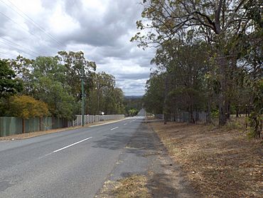
Grassdale Road, 2014
|
|||||||||||||||
| Population | 2,298 (2021 census) | ||||||||||||||
| • Density | 511/km2 (1,320/sq mi) | ||||||||||||||
| Postcode(s) | 4154 | ||||||||||||||
| Area | 4.5 km2 (1.7 sq mi) | ||||||||||||||
| Time zone | AEST (UTC+10:00) | ||||||||||||||
| Location | 15.6 km (10 mi) ESE of Brisbane CBD | ||||||||||||||
| LGA(s) | City of Brisbane (Chandler Ward) |
||||||||||||||
| State electorate(s) | Chatsworth | ||||||||||||||
| Federal Division(s) | Bonner | ||||||||||||||
|
|||||||||||||||
Gumdale is a suburb located on the eastern edge of Brisbane, Queensland, Australia. It is part of the City of Brisbane. In 2021, about 2,298 people lived there.
Contents
Gumdale's Location and Land
Gumdale is about 17.7 kilometers (11 miles) southeast of Brisbane's city center. You can usually drive there in 15 to 20 minutes.
What makes Gumdale special is its large properties. Most homes here sit on big blocks of land. These are often between 5,000 and 10,000 square meters (which is like 1.2 to 2.5 acres). This means Gumdale has many "acreage" properties. Only a small part of the suburb has new housing developments. Gumdale is the closest suburb to Brisbane's city center that offers these large acreage properties.
A Look Back at Gumdale's History
Gumdale has an interesting history. In 1885, a group called the Grassdale Land Company Limited was formed. They bought a large area of land known as Grassdale Paddocks. This land now covers parts of Gumdale, Belmont, and Chandler.
The company decided to sell off parts of this land. They advertised it as a great place for investors, farmers, and workers. They even mentioned that a railway line to Cleveland would pass through the area. This would make it easy to get to the city. On November 28, 1885, they sold 42 lots of land, covering about 144 acres.
The first school in the area opened on August 26, 1935, and was called Grassdale State School. Later, in July 1942, its name was changed to Gumdale State School.
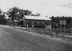
The Grassdale Public Hall also opened on New Cleveland Road in 1937. People in the community worked hard for 21 months to raise money for it.
The original name, Grassdale, came from the grass trees (Xanthorrhoeia) that grew in the area. However, when a post office was planned in 1941, they needed a new name. This was to avoid confusion with another place called Grassdale in South Australia. So, in 1942, the name was officially changed to Gumdale.
A church called St Francis' Anglican Church was built in 1960. It held its last service in 2005, and the land was sold in 2006. Today, a shopping center called Eastside Village is located there.
Gumdale's Population Over Time
The number of people living in Gumdale has grown over the years.
- In 2011, about 950 people lived in Gumdale.
- By 2016, the population had grown to 2,118 people.
- In the most recent count in 2021, Gumdale had a population of 2,298 people.
Schools in Gumdale
Gumdale has one main school:
- Gumdale State School is a government primary school. It teaches students from Prep (the first year of school) up to Year 6. It is located at 677 New Cleveland Road. In 2017, the school had 893 students. It also offers a special education program for students who need extra support.
There are no high schools directly in Gumdale. Students who finish primary school usually go to nearby high schools. These include Brisbane Bayside State College in Wynnum West, Wynnum State High School in Wynnum, or Capalaba State College in Capalaba.
 | Sharif Bey |
 | Hale Woodruff |
 | Richmond Barthé |
 | Purvis Young |


