Ransome, Queensland facts for kids
Quick facts for kids RansomeBrisbane, Queensland |
|||||||||||||||
|---|---|---|---|---|---|---|---|---|---|---|---|---|---|---|---|

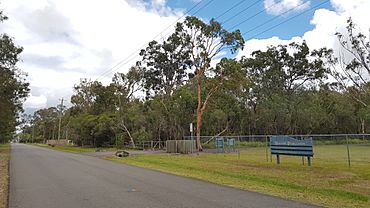
Mookin-Bah Reserve, 2018
|
|||||||||||||||
| Population | 429 (2021 census) | ||||||||||||||
| • Density | 89.4/km2 (232/sq mi) | ||||||||||||||
| Established | 1975 | ||||||||||||||
| Postcode(s) | 4154 | ||||||||||||||
| Area | 4.8 km2 (1.9 sq mi) | ||||||||||||||
| Time zone | AEST (UTC+10:00) | ||||||||||||||
| Location | 19.6 km (12 mi) E of Brisbane CBD | ||||||||||||||
| LGA(s) | City of Brisbane (Chandler Ward) |
||||||||||||||
| State electorate(s) | Chatsworth | ||||||||||||||
| Federal Division(s) | Bonner | ||||||||||||||
|
|||||||||||||||
Ransome is a quiet coastal suburb located in the city of Brisbane, Queensland, Australia. It's known for its natural areas and peaceful environment. In 2021, about 429 people lived in Ransome.
Contents
Exploring Ransome's Geography
Ransome is located about 19.6 kilometers (or 12 miles) east of the very center of Brisbane. It sits right on the edge of the City of Redland.
Ransome's Natural Borders
The suburb has some clear natural boundaries. To the north, it meets Moreton Bay, a large bay with beautiful waters. To the east, you'll find Tingalpa Creek. Chadwell Street forms the southern border, and Lota Creek is loosely the western boundary.
Roads and Residential Areas
Rickertt Road is the main road that goes through Ransome from west to east. It's the only road that lets you travel all the way through the suburb. Molle Road also enters from the southwest and heads east, stopping at Tingalpa Creek. Chelsea Road comes in from the south and goes north, ending at Lota Creek.
There are two main places where people live in Ransome. One is along Rickertt Road, and the other is on Molle Road. Most of the land in Ransome is still undeveloped, meaning it's natural bushland.
Tingalpa Creek Conservation Park
Next to Molle Road and Tingalpa Creek, you'll find the Tingalpa Creek Conservation Park. This park helps protect the natural environment around the creek.
The Railway Line
The Cleveland railway line runs through the northern part of Ransome. It travels through undeveloped bushland. There isn't a train station in Ransome, so residents use stations in nearby suburbs.
Ransome's Coastline and Islands
Even though Ransome touches Moreton Bay, the coastal area is mostly undeveloped land called Ransome Reserve. This reserve even includes two small, unnamed islands! There are walking tracks in the reserve, but they don't go all the way to the bay past the railway line.
Ransome's History
Ransome was named after a man named Charles Horace Ransome. He used to live in the area and owned a sawmill. His sawmill provided firewood to the city and to the Queensland Railways Department. He passed away in 1948.
The suburb officially received its name and boundaries on August 11, 1975, thanks to the Queensland Place Names Board.
Who Lives in Ransome?
In 2021, Ransome had a population of 429 people. It's a small community, and its population has changed a bit over the years. For example, in 2011, there were 474 people, and in 2016, there were 405.
Education in Ransome
There are no schools located directly within Ransome. However, students can easily go to schools in nearby suburbs.
- The closest primary school is Gumdale State School, which is to the southwest in Gumdale.
- For high school, students can attend Wellington Point State High School to the east, Capalaba State College to the south, or Wynnum State High School to the north.
Parks and Green Spaces
Ransome has several parks where residents can enjoy the outdoors. These parks offer green spaces for relaxation and play.
- Chadwell Street Park (27°30′04″S 153°11′03″E / 27.5010°S 153.1843°E)
- Chelsea Road Park (no.258) (27°29′20″S 153°10′28″E / 27.4889°S 153.1745°E)
- Chelsea Road Park (no.303) (27°29′29″S 153°10′59″E / 27.4913°S 153.1830°E)
- Chelsea Road Park (no.498) (27°28′38″S 153°10′54″E / 27.4771°S 153.1818°E)
- Chelsea Road Park (nos.399-551) (27°28′58″S 153°11′06″E / 27.4827°S 153.1850°E)
- Green Camp Road Park (27°28′48″S 153°10′21″E / 27.4800°S 153.1725°E)
- Molle Road Park (27°29′50″S 153°11′05″E / 27.4973°S 153.1847°E)
- Ransome Road Park (27°28′40″S 153°11′16″E / 27.4777°S 153.1877°E)
- Rickertt Road (no 277) Park (27°29′19″S 153°11′05″E / 27.4887°S 153.1848°E)
- Rickertt Road Park (27°29′04″S 153°10′13″E / 27.4844°S 153.1702°E)
 | John T. Biggers |
 | Thomas Blackshear |
 | Mark Bradford |
 | Beverly Buchanan |


