
Benson, Oxfordshire facts for kids
Quick facts for kids Benson |
|
|---|---|
 St Helen's parish church |
|

Benson
|
|
| Area | 9.84 km2 (3.80 sq mi) |
| Population | 4,754 (2011 Census) |
| • Density | 483/km2 (1,250/sq mi) |
| OS grid reference | SU6191 |
| Civil parish |
|
| District | |
| Shire county | |
| Region | |
| Country | England |
| Sovereign state | United Kingdom |
| Post town | Wallingford |
| Postcode district | OX10 |
| Dialling code | 01491 |
| Police | Thames Valley |
| Fire | Oxfordshire |
| Ambulance | South Central |
| EU Parliament | South East England |
| UK Parliament |
|
Benson is a village in South Oxfordshire, England. It's also a "civil parish," which is a local area with its own council. In 2011, about 4,754 people lived here.
The village is located about 2.4 kilometers (1.5 miles) north of Wallingford. It sits at the bottom of the Chiltern Hills. A small chalk stream called Ewelme Brook flows through Benson. This brook then joins the River Thames right next to Benson Lock.
Contents
Geography: Where Benson Is Located
Benson is on the north and east sides of the River Thames. The village is built on river silts and gravel. This land is a bit higher than the marshy areas nearby.
For a long time, farming was the main way people earned a living here. This was because the land around Benson is very fertile. You can find trout in the brook that runs through the village. There are also American signal crayfish, which are an invasive species.
Climate: Weather in Benson
Benson is known as a "frost-pocket." This means it sometimes has the coldest night-time temperatures in the UK. This special weather might have helped develop modern weather science. A weather observatory was set up here in the early 1800s.
| Climate data for RAF Benson (1991–2020) | |||||||||||||
|---|---|---|---|---|---|---|---|---|---|---|---|---|---|
| Month | Jan | Feb | Mar | Apr | May | Jun | Jul | Aug | Sep | Oct | Nov | Dec | Year |
| Mean daily maximum °C (°F) | 7.7 (45.9) |
8.3 (46.9) |
10.9 (51.6) |
14.0 (57.2) |
17.2 (63.0) |
20.3 (68.5) |
22.8 (73.0) |
22.3 (72.1) |
19.3 (66.7) |
14.9 (58.8) |
10.7 (51.3) |
8.1 (46.6) |
14.8 (58.6) |
| Mean daily minimum °C (°F) | 1.1 (34.0) |
1.0 (33.8) |
2.2 (36.0) |
3.8 (38.8) |
6.8 (44.2) |
9.7 (49.5) |
11.7 (53.1) |
11.6 (52.9) |
9.3 (48.7) |
6.8 (44.2) |
3.6 (38.5) |
1.2 (34.2) |
5.7 (42.3) |
| Average rainfall mm (inches) | 58.9 (2.32) |
42.1 (1.66) |
39.8 (1.57) |
49.0 (1.93) |
52.3 (2.06) |
46.2 (1.82) |
45.2 (1.78) |
53.3 (2.10) |
49.9 (1.96) |
68.9 (2.71) |
70.0 (2.76) |
58.1 (2.29) |
633.7 (24.95) |
| Average rainy days (≥ 1 mm) | 11.5 | 9.6 | 8.6 | 9.7 | 9.3 | 8.0 | 8.0 | 9.2 | 8.3 | 10.8 | 12.1 | 10.9 | 116.0 |
| Mean monthly sunshine hours | 59.1 | 76.4 | 117.2 | 168.3 | 208.5 | 208.4 | 228.1 | 201.4 | 148.7 | 108.5 | 66.4 | 53.7 | 1,644.8 |
| Source: Met Office | |||||||||||||
History: Benson Through Time
Etymology: What's in a Name?
The name Benson first appeared in old writings around the 800s. It was spelled Bænesingtun or Benesingtun. The name likely comes from a person's name, Benesa. It also includes the old English word tūn, which means 'estate' or 'farmstead'. So, Benson once meant "farmstead of Benesa."
Over time, the name changed. It was called Besinton between 1140 and 1315. In 1526, it was Benston. The name Benson as we know it appeared in the early 1800s. However, Bensington was still used in official papers for a while.
Archaeology: Ancient Discoveries
People have lived in the Benson area for a very long time. Evidence shows human presence from about 10,000 BCE, which is the Mesolithic period. Benson was also an ancient British town during the Roman times.
Recently, during digging for new houses, archaeologists found more evidence. They found pits and post holes from the early Neolithic period (around 3500 BCE). They also found signs of a possible roundhouse from the later Bronze Age or early Iron Age (11th – 8th centuries BCE). Even older Saxon buildings from the 5th or 6th centuries CE were discovered.
Medieval Manor: A Royal Estate
In 779, the area was taken by Offa of Mercia after a battle. By the 880s, Benson was definitely a royal manor. This means it was owned by the king.
In 1086, the Domesday Book called Benson "the richest royal manor in Oxfordshire." The manor was very valuable. Benson itself was the most important part of this large estate.
Parish Church: St Helen's

The main church in Benson is St Helen's. Parts of it are very old. It has a mix of old styles, including Norman and Decorated. The church tower was rebuilt in 1794.
The church has a clock on its east side. During the Second World War, this clock became famous. It had a mistake: the nine o'clock marker was shown as "XI," just like the eleven o'clock marker. A German radio broadcaster, William Joyce (also known as Lord Haw Haw), joked about a village with a clock that had "two elevens." Soon after, RAF Benson was bombed.
The church tower has eight bells. Six of them were made in 1781. The other two were added later in 1852 and 1922. In 2009, the old wooden bell frame was replaced with a new steel one.
Social and Economic History: How Life Changed


Benson was important during the English Civil War. It was near major Royalist cities like Oxford. Some say it was the last place held by the Royalists to surrender. King Charles I himself is said to have held court in a building in Benson. This building is still called the Court House.
A type of river lock called a flash lock was built on the Thames at Benson in 1746. Later, a pound lock was built in 1788 and rebuilt in 1870.
In the 1700s and 1800s, Benson was a busy stop for coaches traveling between London and Oxford. Its wide open square had many coaching inns. At its busiest, Benson had four large inns, ten smaller pubs, and a blacksmith.
However, when railways became popular in the 1840s, coach travel quickly declined. Benson became less important as a travel stop. This, along with changes in farming, caused the village's population to drop.
Benson later recovered as cars and motor coaches became common. This led to new roadside cafes, which were like the modern versions of the old coaching inns.
Amenities: What Benson Offers Today
Today, Benson is a village where many people live and travel to work in other towns. It has a Church of England primary school. There is also a pre-school for younger children.
The village has a doctor's surgery. There are two public houses (pubs): The Crown Inn and the Three Horseshoes. There used to be more pubs, but some have become private homes. Benson also has about a dozen shops, including a supermarket and a pharmacy. On the main road outside the village, there's a McDonald's with a drive-through and a Marks and Spencer food store.
The village play area was reopened in 2021. It is named after a local teenager, Faye Elizabeth Grundy. Because RAF Benson is nearby, there can be aircraft noise. This can sometimes affect property values compared to other villages.
In Popular Media
In 1993, the River Thames at Benson was used for filming. It appeared in Episode 7 of Series 3 of the BBC comedy show Keeping up Appearances.
Images for kids
-
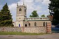
St Helen's parish church
-
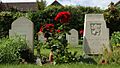
Second World War graves of Polish and Czechoslovak airmen in the extension of St Helen's parish churchyard
-
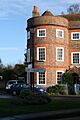
13 Castle Square, a mid-18th-century house
-
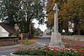
Benson war memorial
-
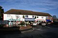
Row of shops in the High Street
See also
 In Spanish: Benson (Oxfordshire) para niños
