Big Burro Mountains facts for kids
Quick facts for kids Big Burro Mountains |
|
|---|---|

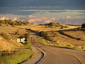
Foothills at northeast Big Burro Mtns
(north Little Burro Mountains, US Route 180 in New Mexico) |
|
| Highest point | |
| Peak | Burro Peak |
| Elevation | 8,035 ft (2,449 m) |
| Dimensions | |
| Length | 35 mi (56 km) NW-SE |
| Width | 15 mi (24 km) |
| Geography | |
| Country | United States |
| Communities | Cliff, Gila, Silver City, White Signal and Red Rock |
| Range coordinates | 32°42′32″N 108°32′17″W / 32.708965°N 108.538107°W |
The Big Burro Mountains are a mountain range in Grant County, New Mexico. They are about 35-mile (56 km) long. You can find them about 15 miles southwest of Silver City.
These mountains are special because the Continental Divide of the Americas crosses them. This important line separates rivers that flow to the Atlantic Ocean from those that flow to the Pacific Ocean. It goes over Burro Peak, the highest point in the range.
The Gila River flows near the northwest part of the mountains. This river starts in the Gila Wilderness. It then travels towards Arizona. The Gila River is a major water source in the dry Sonoran Desert. The Big Burro Mountains are also on the edge of the Chihuahuan Desert. This desert stretches into southern New Mexico.
About the Big Burro Mountains
The Big Burro Mountains are about 35 miles (56 km) long. They can be up to 18 miles (29 km) wide in some places. These mountains are a link between different natural areas. To the north is the Gila Wilderness. To the southwest are the long Animas Valley and Playas Valley.
The area around the Big Burro Mountains is quite rugged. It connects to other mountain ranges in western New Mexico. This region is part of a larger natural zone. It stretches from Arizona into New Mexico.
Tallest Peaks
The highest point in the Big Burro Mountains is Burro Peak. It stands tall at 8,035 feet (2,449 m). You can find Burro Peak at 32°35′26″N 108°25′58″W / 32.590635°N 108.432827°W. Another important peak is Bullard Peak. It is about 7,064 feet (2,153 m) high. Bullard Peak is near the center of the mountain range.
How to Visit
The Big Burro Mountains are easy to reach. Several towns are located around them. To the north, you'll find Cliff and Gila. Red Rock is to the west. On the east side are Silver City and Tyrone. And to the southeast is White Signal. These towns make it simple for people to explore the mountains.
The Continental Divide
The Continental Divide is a very important line. It separates the flow of water across North America. In this region, it moves away from the forested mountains. It travels southwest from Silver City.
The Divide crosses the Big Burro Mountains. Then it goes around the Cedar Mountain Range. After that, it crosses the land that divides the water for the northern Playas Valley. This is west of Hachita. Finally, the Divide enters a series of mountains that run north to south. These include the Pyramid and Animas Mountains. From there, it continues south into Chihuahua, Mexico.
 | Dorothy Vaughan |
 | Charles Henry Turner |
 | Hildrus Poindexter |
 | Henry Cecil McBay |


