
Banna (Birdoswald) facts for kids
Quick facts for kids Banna |
|
|---|---|
 |
|

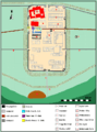
Location in Cumbria
|
|
| Known also as | Birdoswald Roman Fort |
| Founded | c. 112 AD |
| Abandoned | c. 500 AD |
| Place in the Roman world | |
| Province | Britannia |
| Structure | |
| — Stone structure — | |
| — Wood and earth structure — | |
| Location | |
| Coordinates | 54°59′22″N 2°36′08″W / 54.9894°N 2.6023°W |
| County | Cumbria |
| Country | England |
| Reference | |
| UK-OSNG reference | NY615663 |


Birdoswald Roman Fort, originally called Banna, was an important Roman fort. It was located near the western end of Hadrian's Wall in Britannia, which was a Roman province. Today, a farm called Birdoswald stands on the old fort's site.
Birdoswald is special because it's the only place on Hadrian's Wall where we know people lived long after the Romans left. Archaeologists have been studying it for many years. It is one of the best-preserved forts along the 16 forts of Hadrian's Wall.
The fort sits on a high, triangular piece of land. Cliffs protect it on the south and east sides. It overlooks a wide bend in the River Irthing in Cumbria. The Roman name Banna means "horn" in Celtic. This name likely came from the shape of the land where the fort was built.
Cumbria County Council managed Birdoswald fort from 1984 to 2004. After that, English Heritage took over its care.
Contents
What Was Birdoswald Fort Like?
Roman soldiers called auxiliaries lived at Birdoswald. They were there from about 112 AD until 400 AD. In this part of Hadrian's Wall, the wall was first built from turf. Later, it was rebuilt using stone.
The stone fort was built after the wall. It had a typical playing card shape with gates on the east, west, and south. Inside, there were stone buildings. These included a main headquarters building (called a principia) and granaries (called horrea) for storing grain. There were also barracks for the soldiers.
Unusually, this auxiliary fort also had an exercise building. This might have been because it was hard to train soldiers in the exposed northern English weather.
Discovering Birdoswald's Past
Archaeologists have been digging at Birdoswald for over 100 years. Early excavations happened in the 1910s and 1920s. More digs took place in the 1940s.
Between 1987 and 1992, new excavations showed something amazing. People lived on the site of the fort's granaries without a break from the late Roman period until possibly 500 AD. The granaries were replaced by two large timber halls. These halls are similar to others found in Britain from the 5th and 6th centuries.
Tony Wilmott, who led the excavations, thinks the fort was a base for a local group after Roman rule ended. This group might have been related to the Roman soldiers who used to live there.
Finding Hidden Structures
From 1997 to 2001, special surveys were done. These surveys used magnets and electrical resistance to map what was underground. They showed that the fort's hidden remains were well preserved.
The surveys also found two civilian settlements (called vici). These were located outside the fort on its eastern and western sides. The surveys also found where a Roman bathhouse was located. It was in the valley of the River Irthing.
In 2000, a TV show called Time Team also excavated an area near the fort. They found signs of another settlement outside the fort walls. However, this area is prone to erosion, so much of it might have fallen over the cliffs.
How the Wall Changed Near Birdoswald

The two-mile section of Hadrian's Wall around Birdoswald is very interesting. It's the only known part where the original turf wall was later replaced by a stone wall on a different line.
When the stone wall was built (probably in the 130s AD), its path moved about 50 meters north. It was moved to line up with the fort's north wall. The reasons for this change are not fully clear. One idea is that it was to improve how signals were sent along the wall. This area is unique because you can compare both walls directly.
Willowford Bridge Remains
About 600 meters east of Birdoswald, at the bottom of a steep slope, are the remains of Willowford bridge. This bridge carried Hadrian's Wall across the River Irthing. Over many centuries, the river has moved westward. This means the east end of the bridge is now on dry land. The west end has likely been washed away by the river.
Even so, the visible remains are very impressive. Until 1996, you couldn't easily reach these remains from the fort. But now, there's a footbridge. An RAF helicopter helped put the footbridge in place.
The Maiden Way Road
Birdoswald fort was connected by a Roman road to another fort. This road was sometimes called the Maiden Way. It led to Bewcastle, an outpost fort seven miles to the north. Signals could be sent between the two forts using two signaling towers.
Birdoswald Roman Fort Today


Today, English Heritage manages the Birdoswald fort site. It is open to visitors as Birdoswald Roman Fort. The visitor center has displays and models of the fort. You can learn about life in Roman Britain and the fort's history. There are also exhibits about archaeological discoveries made there. Visitors can walk around the excavated remains of the fort.
Images for kids
-
Plan of Birdoswald Fort
-
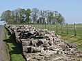
Hadrian's Wall west of Birdoswald
-
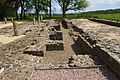
Birdoswald Fort

_-_geograph.org.uk_-_1357856.jpg)

