Blairmore, Alberta facts for kids
Quick facts for kids
Blairmore
Tenth Siding
The Springs |
|
|---|---|
|
Former village
|
|

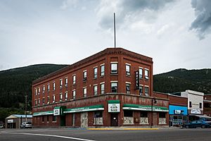
The Cosmopolitan Hotel and Bar in Blairmore
|
|
| Country | Canada |
| Province | Alberta |
| Census division | No. 15 |
| Specialized municipality | Municipality of Crowsnest Pass |
| Village | September 3, 1901 |
| Town | September 29, 1911 |
| Amalgamated | January 1, 1979 |
| Government | |
| • Type | Unincorporated |
| Area | |
| • Land | 2.04 km2 (0.79 sq mi) |
| Population
(2021)
|
|
| • Total | 1,522 |
| • Density | 741.6/km2 (1,921/sq mi) |
| Time zone | UTC−7 (MST) |
| • Summer (DST) | UTC−6 (MDT) |
Blairmore is a community found in the Rocky Mountains in southwest Alberta, Canada. It is part of the larger Municipality of Crowsnest Pass. Blairmore used to be its own town. But in 1979, it joined with four other towns to create the Municipality of Crowsnest Pass. Today, Blairmore is the main business hub of the Crowsnest Pass area.
Contents
History of Blairmore
Early Days and Growth
Blairmore started as a stop for the Canadian Pacific Railway. It was first called Tenth Siding or The Springs. This name came from a cold sulphur spring nearby. In November 1898, the settlement was renamed Blairmore. A post office opened there the next year.
For ten years, a disagreement over land slowed down the town's early growth. The main industries in Blairmore were lumber and, after 1907, coal mining. Other businesses soon followed. On September 29, 1911, Blairmore officially became a town.
Becoming a Regional Centre
The nearby community of Frank faced tough times. Because of this, Blairmore quickly became the most important economic centre in the region. The Greenhill mine, just north of Blairmore, was very important to the community. It provided many jobs until it closed in 1957.
Unique Local Government
In the 1930s, Blairmore had a unique local government. In 1933, the town elected Canada's first town council and school board that supported certain political ideas. This council changed the tax system. They also decided not to observe Remembrance Day in the usual way. Instead, they honored the Russian Revolution. A street was even named after Tim Buck, a leader of a political party. However, the next town council changed the street name back.
Joining Crowsnest Pass
In 1979, Blairmore joined with four other communities. These were Coleman, Frank, Hillcrest Mines, and Bellevue. Together, they formed the larger Municipality of Crowsnest Pass.
Geography of Blairmore
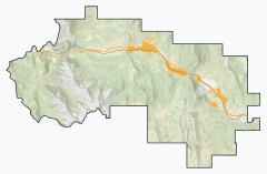
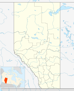
Blairmore is located in the Canadian Rockies in southwest Alberta. It is about 135 kilometres (84 miles) west of Lethbridge. You can find it on Highway 3 (Crowsnest Highway). It is also about 20 kilometres (12 miles) east of the British Columbia border. Other communities in Crowsnest Pass are close by. Frank is about 3 kilometres (1.9 miles) to the east. Coleman is about 6 kilometres (3.7 miles) to the west.
Geology Around Blairmore
The rocks in the Blairmore area are special. They are Volcanic rocks that are part of something called the Crowsnest Formation. In the late 1980s, geologists became very interested in these rocks. They found tiny amounts of gold in some of them. There's even a very rare volcanic rock called Blairmorite. It was named after Blairmore because it was found there.
Population of Blairmore
| Population history of Blairmore | ||||||||||||||||||||||||||||||||||||||||||||||||||||||||||||||||||||||||||||||||||
|---|---|---|---|---|---|---|---|---|---|---|---|---|---|---|---|---|---|---|---|---|---|---|---|---|---|---|---|---|---|---|---|---|---|---|---|---|---|---|---|---|---|---|---|---|---|---|---|---|---|---|---|---|---|---|---|---|---|---|---|---|---|---|---|---|---|---|---|---|---|---|---|---|---|---|---|---|---|---|---|---|---|---|
|
|
|||||||||||||||||||||||||||||||||||||||||||||||||||||||||||||||||||||||||||||||||
| Source: Statistics Canada | ||||||||||||||||||||||||||||||||||||||||||||||||||||||||||||||||||||||||||||||||||
In the 2021 Census, Blairmore had a population of 1,522 people. These people lived in 731 homes. This was a small decrease from its population of 1,545 in 2016. Blairmore covers an area of 2.04 square kilometres (0.79 square miles). This means there were about 741.6 people living in each square kilometre in 2021.
In the 2016 Census, Blairmore had 1,545 people. They lived in 731 homes. This was a small increase from its 2011 population of 1,521. With the same land area, the population density was about 757.4 people per square kilometre in 2016.
 | Jessica Watkins |
 | Robert Henry Lawrence Jr. |
 | Mae Jemison |
 | Sian Proctor |
 | Guion Bluford |


