
Blanchardstown facts for kids
Quick facts for kids
Blanchardstown
Baile Bhlainséir
|
|
|---|---|
|
Suburb (village core)
|
|

Clockwise from top: Fingal County Council's Civic Offices; Millennium Park; businesses in Blanchardstown during the COVID-19 pandemic
|
|

Blanchardstown
Location in Dublin

Blanchardstown
Location in Ireland
|
|
| Country | Ireland |
| Province | Leinster |
| Traditional county | County Dublin |
| County | Fingal |
| Elevation | 56 m (184 ft) |
| Time zone | UTC±0 (WET) |
| • Summer (DST) | UTC+1 (IST) |
| Eircode routing key |
D15
|
| Telephone area code | +353(0)1 |
| Irish Grid Reference | O055383 |
Blanchardstown (Irish: Baile Bhlainséir) is a large area in Dublin, Ireland. It's located about 10 kilometres (6 miles) northwest of Dublin city centre. What started as a small village in the 1960s has grown into the biggest urban area in Fingal, which is a county in Ireland.
Blanchardstown is part of the historic barony of Castleknock. It's also in the Dublin 15 postal area and the Dublin West area for elections.
One of Ireland's largest shopping and fun places, the Blanchardstown Centre, is found here.
Contents
What's in a Name?
The name Blanchardstown comes from the Blanchard family. They were given land here between the years 1250 and 1260. The name 'Blanchard' likely comes from an old French word, 'blanch', which means white. This might have referred to someone with white or fair hair.
Where is Blanchardstown?

Blanchardstown is just outside Dublin's M50 motorway ring road. This is a big road that goes around Dublin. It's a bit north of where the M50 crosses the River Liffey (which has a toll).
The main part of Blanchardstown is a townland (a small land division) with the same name. It shares borders with other areas:
- To the east is Castleknock.
- To the west are Clonsilla and Ongar.
- To the north are Tyrellstown and Hollystown.
- To the south and southeast are Porterstown and Diswellstown.
The Royal Canal and the Dublin-Sligo railway line run along the southern edge of Blanchardstown.
A Look Back in Time
Blanchardstown and its neighbour, Castleknock, grew up together for a long time. They shared a similar history until the 1800s.
Blanchardstown was a quiet village in western County Dublin until the late 1960s. That's when the first housing estates started to be built. From the early 1970s onwards, both Blanchardstown and Castleknock grew very quickly. By the 1970s and 80s, the village became a part of Dublin's growing suburbs.
The Institute of Technology, Blanchardstown (ITB), which is now part of TU Dublin, was opened in 1999.
Churches and Parishes
In the 1800s, the Roman Catholic area of Blanchardstown covered a much larger space. This included many areas now in the Dublin 15 postal district.
After some old laws that limited Catholics were changed, it became possible to build new churches. A new priest, Fr Michael Dungan, arrived in Blanchardstown in 1839. He helped build several new churches. These churches are now independent parishes (church areas) on their own. He also invited religious groups to help educate Catholic children.
St Brigid's Church in Blanchardstown was built in 1837. It was built on the site of an even older church from before 1731. This church is like the "mother church" for 12 other churches that were formed from its original large parish over the next 156 years. Some of these include:
- Chapelizod - "Nativity of the Blessed Virgin Mary" (separated in 1883)
- Navan Road - "Our Lady Help of Christians" (separated from Chapelizod in 1953)
- Castleknock - "Our Lady Mother of the Church" (separated in 1976)
- Laurel Lodge / Carpenterstown - "St Thomas, the Apostle" (separated from Castleknock in 1983)
- Porterstown - "St Mochta's" (separated from Castleknock in 1986. This church was built in 1890 as a smaller church for Blanchardstown.)
- Corduff - "St Patrick's Church" (separated in 1976)
- Mountview - "St Philip, the Apostle" (separated from Corduff in 1979)
- Blakestown - "Church of Mary of the Servants" (separated from Corduff in 1979)
- Huntstown - "Church of the Sacred Heart of Jesus" (separated from Blakestown in 1981)
- Littlepace - "Chapel of Ease, Mary, Mother of Hope" (still being developed since 2002)
- Huntstown - "Church of the Sacred Heart of Jesus" (separated from Blakestown in 1981)
- Hartstown - "St Ciarán' Church" (separated in 1979)
- Mulhuddart / Lady's Well - "St Luke, the Evangelist" (separated in 1993)
Getting Around

Blanchardstown has good transport links.
Trains
There are three Irish Rail train stations nearby: Castleknock, Coolmine, and Clonsilla. Trains from these stations go to Dublin city centre (at Dublin Connolly, Tara Street, and Dublin Pearse stations). They also go towards Maynooth, Longford, and Sligo. From Clonsilla station, you can also catch a train to Docklands railway station and places like Hansfield and Dunboyne.
Buses
Many Dublin Bus and Go-Ahead Ireland routes serve Blanchardstown. These include routes like 37, 38, 38A, 38B, 38D, 39, 39A, 40D, 70, 76A, 220, 236, 236A, 238, 270, L52, N4, and W4. Route 39A even runs 24 hours a day, 7 days a week!
There's also a Nitelink bus (route 70N) on Friday and Saturday nights. Bus Éireann services also pass through Blanchardstown on Routes 105, 109, and 111.
Things to Do and See
.jpg)
Blanchardstown has many useful places. Connolly Hospital, one of Dublin's main hospitals, is located here. It's also a teaching hospital for university students. The Institute of Technology, Blanchardstown (now part of TU Dublin) is also in the area.
For shopping, you can visit the Blanchardstown Centre, which is a huge shopping mall with over 180 stores. Next to it is the WestEnd Shopping Park. There's also a SuperValu supermarket on the main street.
Blanchardstown has a big public library and the Draíocht Arts Centre, where you can enjoy shows and art. There's also a large Garda station (police station) on Blanchardstown's main street.
Learning in Blanchardstown

There are several primary schools (called national schools) in Blanchardstown. These include Scoil Bhríde (for girls) and Scoil Bhríde (for boys) on Church Avenue. Other primary schools are Sacred Heart of Jesus Primary School (Huntstown), Scoile Olilibheir (Coolmine), St Ciaran's Primary School (Hartstown), Mary Mother of Hope Primary School (Clonee), and St Phillip the Apostle Primary School (Mountview).
For older students, there are secondary schools like Blakestown Community School, Rath Dara Community College, Hartstown Community School, and Coolmine Community School.
.jpg)
The Institute of Technology, Blanchardstown campus, which is now part of TU Dublin, offers third-level education.
Sports and Fun
The National Sports Campus is in Blanchardstown. This huge campus includes the National Aquatic Centre. This is a major indoor swimming facility with a 50-metre pool, a diving pool, a fun leisure pool, and an aquapark. It also has a fitness centre. The National Aquatic Centre hosted the 2003 Special Olympics World Summer Games and many international swimming events since then.
There are several GAA clubs in the Blanchardstown area, such as St. Brigids, Castleknock and St. Peregrines, Clonsilla. You can also find a few association football (soccer) clubs, including St. Mochta’s.
Religion


St Brigid's Roman Catholic Church is located behind Main Street on Church Avenue. The first stone for the church was laid on October 13, 1835. The first Mass was held there on October 29, 1837. The church and its unique Flemish spire were finally finished in 1863.
As mentioned in the history section, St Brigid's Church is considered the "mother church" for many other Catholic churches in the wider Dublin 15 area. These churches were formed over time from the original large parish of Blanchardstown.
How Blanchardstown is Run
.jpg)
For elections to Dáil Éireann (Ireland's main parliament), Blanchardstown is part of the Dublin West area. This area chooses four TDs (members of parliament).
For elections to Fingal County Council (the local government), Blanchardstown is split between two areas: Castleknock (which elects 4 councillors) and Mulhuddart (which elects 5 councillors).
Famous People from Blanchardstown
- Joan Burton, a former politician who was a government minister.
- Jade Jordan, an actor and author.
- Siva Kaneswaran, a musician from the band The Wanted.
- William Mooney, a cricketer.
- John Troy, who became the Roman Catholic Archbishop of Dublin, was born nearby in Porterstown.
- Leo Varadkar, a politician who has been Taoiseach (Prime Minister) of Ireland, grew up in the Blanchardstown/Castleknock area.
Images for kids
-
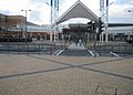
Blanchardstown Centre
-
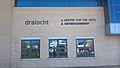
Draíocht Arts Centre
-

Blanchardstown Garda Station
-
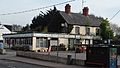
Shop on Blanchardstown's main street

.jpg)


