Bledsoe Creek State Park facts for kids
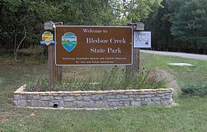
Bledsoe Creek State Park is a fun state park located in Sumner County, Tennessee. It covers about 169 acres (0.68 km2) of land. The park is managed by the Tennessee Department of Environment and Conservation.
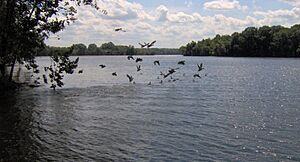
This park is found along the west side of Bledsoe Creek. This creek flows into Old Hickory Lake, which is a large lake created in 1954. The lake was formed when the U.S. Army Corps of Engineers built the Old Hickory Dam on the Cumberland River.
Bledsoe Creek State Park was first set up by the U.S. Army Corps of Engineers for people to enjoy outdoor activities. In 1973, the state of Tennessee officially made it a state park. It's a popular spot for camping, boating, and fishing. The park also has several miles of hiking trails and offers special programs to teach visitors about nature.
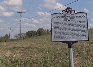
The area around the park is full of history. Nearby, you can find historic sites like Wynnewood and Cragfont. There's also Bledsoe's Fort Historic Park and an ancient village site from the Mississippian culture. The Cairo Rosenwald School is also close by. All these places show how important this area has been for a very long time.
Contents
Exploring Bledsoe Creek State Park
Bledsoe Creek State Park is a beautiful place to visit. It's located in the Central Basin region of Tennessee. The park has gentle hills that lead down to a flat shoreline.
Most of the park is covered in forests. About 12% of the park is water, with the rest being open fields or developed areas. You can see many animals here, like whitetail deer, wild turkey, beaver, bobcat, fox, and muskrat. Sometimes, in the winter, you might even spot Bald eagles or golden eagles flying overhead!
The park is easy to find, just off Tennessee State Route 25. It's about halfway between Gallatin and Hartsville. The park is about 35 miles (56 km) northeast of Nashville. The Tennessee Department of Environment and Conservation manages the park, leasing the land from the U.S. Army Corps of Engineers.
What to Do at the Park
Bledsoe Creek State Park has lots of things for visitors to do. There's a campground with 57 sites where you can stay overnight. The park also has two boat ramps, making it easy to get out on Old Hickory Lake. You'll find two picnic pavilions and several playground areas for kids.
Old Hickory Lake is a great place for fishing. It's stocked with fish like bluegill, crappie, catfish, and bass. The park also has a special area for watching wildlife. They often offer environmental programs to help you learn more about the plants and animals in the park.
Hiking Trails
There are over 6 miles (9.7 km) of hiking trails at Bledsoe Creek State Park. These trails wind through the forests and along the lakeshore.
- The Shoreline Trail is about 2.5 miles (4.0 km) long. It mostly follows the edge of the lake and goes through the wildlife observation area.
- The High Ridge Trail is about 3 miles (4.8 km) long. It follows a ridge near the northern part of the park.
- The Birdsong Trail is a paved trail about .75-mile (1.21 km) long. It goes through the woods near the visitor center.
Since 2003, park staff and volunteers have been working to list all the different plants and animals found in the park. Money from Tennessee's Iris License Plate project has helped them plant new trees and plants.
A Look Back: History of the Area
People have lived and hunted in the Sumner County area for more than 12,000 years. Very old tools and artifacts have been found near the park. A large village from the Mississippian culture (around 1000-1500 A.D.) was located nearby at Castalian Springs.
In the 1700s, Native American tribes like the Shawnee, Cherokee, and Chickasaw lived in this region. Later, long hunters, who were explorers and hunters, came to the area. One of these hunters, Isaac Bledsoe, discovered the creek and salt lick that are now named after him.
Early Settlements and Forts
After the American Revolutionary War, settlers from Europe began to move into Middle Tennessee. To protect themselves from Native American attacks, they built small forts. Isaac Bledsoe built Bledsoe's Station in the early 1780s.
However, conflicts between settlers and Native Americans grew. Isaac's brother, Anthony Bledsoe, was killed at Bledsoe's Station in 1788. In 1791, Jacob Ziegler built Ziegler's Fort near where Bledsoe Creek State Park is today. This fort was attacked, and Ziegler and others were killed. The attacks finally stopped in 1794.
The Town of Cairo
In 1799, General James Winchester and William Cage, Jr. bought land near Bledsoe's Creek to start a new town called "Cairo." The name might have come from a popular French Revolution song or from Winchester's interest in ancient Egyptian cities.
Cairo quickly became an important trading center on the river. Winchester and Cage ran a successful business, trading goods by flatboat all the way to New Orleans. By 1812, Cairo had mills, a tavern, and other businesses.
However, after Winchester died in 1826, and a new main road was built away from Cairo, the town began to decline. In 1923, the community used special funds to build the Cairo Rosenwald School for African-American children. This school operated until 1959 and is now a historic site.
 | Jackie Robinson |
 | Jack Johnson |
 | Althea Gibson |
 | Arthur Ashe |
 | Muhammad Ali |


