Bloomfield, Queensland facts for kids
Quick facts for kids BloomfieldQueensland |
|||||||||||||||
|---|---|---|---|---|---|---|---|---|---|---|---|---|---|---|---|

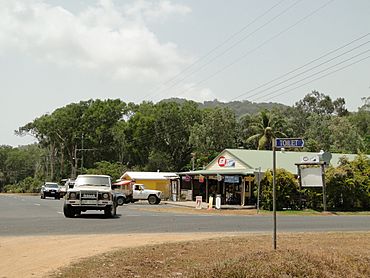
Ayton general store, 2009
|
|||||||||||||||
| Population | 228 (2021 census) | ||||||||||||||
| • Density | 0.2740/km2 (0.710/sq mi) | ||||||||||||||
| Postcode(s) | 4895 | ||||||||||||||
| Area | 832.1 km2 (321.3 sq mi) | ||||||||||||||
| Time zone | AEST (UTC+10:00) | ||||||||||||||
| Location | |||||||||||||||
| LGA(s) |
|
||||||||||||||
| State electorate(s) | Cook | ||||||||||||||
| Federal Division(s) | Leichhardt | ||||||||||||||
|
|||||||||||||||
Bloomfield is a small rural town and coastal area in Queensland, Australia. It is located in the far north of the state. The area is split between the Shire of Cook and the Shire of Douglas. In 2021, about 228 people lived in Bloomfield.
The small community of Ayton is part of Bloomfield. It is located near the mouth of the Bloomfield River. There is also a place called China Camp, which used to be a tin mining area. It is now abandoned.
Contents
Where is Bloomfield located?
Bloomfield is divided into two main parts. One part is in the Shire of Cook, and the other is in the Shire of Douglas. A narrow strip of land, about 1 kilometer wide, separates them. This strip follows Granite Creek, which flows into the Bloomfield River. The Bloomfield River then flows into the Coral Sea.
Much of Bloomfield is covered by beautiful national parks. These include the Ngalba Bulal National Park and the Daintree National Park. These parks are home to amazing plants and animals.
Even though Bloomfield is the official town center, most of the activity happens in Ayton. Ayton is on the northern side of the Bloomfield River. The main Bloomfield town area mostly has the local school.
What is the history of Bloomfield?
Traditional Owners and Language
The land around Bloomfield has a rich history. It is the traditional home of the Yalanji people. Their language is also known as Kuku Yalanji. This Aboriginal language is spoken in Far North Queensland.
The Yalanji language area stretches from the Mossman River to the Annan River. It goes from the Pacific Ocean inland towards Mount Mulgrave. This includes many towns and areas like Cooktown and Wujal Wujal.
How Bloomfield Got Its Name
The town and area of Bloomfield are named after the Bloomfield River. This river is an important natural feature of the region.
Early Industries
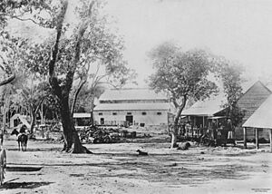
In 1882, a company called the Bloomfield River Sugar Company was started. Frederick Bauer and his sons created a sugarcane farm called Vilele. They built a sugar mill that began working in 1885. They also built a saw mill and a long tramway to move things around. However, the sugar mill closed in 1890 because it was not making enough money.
Schools in Bloomfield
Education has been important in the area for a long time. Ayton Provisional School first opened around 1897. It became Ayton State School in 1909. But it closed in 1924 because there were not enough students.
Later, Bloomfield River State School opened on July 16, 1952. This school still serves the community today.
What facilities are in Bloomfield?
The Cook Shire Council runs a public library in Ayton. This library is a great resource for local residents.
What about education in Bloomfield?
Bloomfield River State School is a government primary school. It teaches students from Prep (the first year of school) to Year 6. In 2017, the school had 41 students. It had 6 teachers and 9 other staff members. The school is located at 3202 Rossville-Bloomfield Road.
The closest primary school is in Rossville, about 30 minutes away. For older students, the nearest high school is in Cooktown. Cooktown is about an hour's drive from Bloomfield.
 | Aurelia Browder |
 | Nannie Helen Burroughs |
 | Michelle Alexander |


