Bodie Hills facts for kids
Quick facts for kids Bodie Hills |
|
|---|---|
 |
|
| Highest point | |
| Elevation | 2,871 m (9,419 ft) |
| Geography | |
| Country | United States |
| State | California |
| District | Mono County |
| Range coordinates | 38°15′20.704″N 119°5′24.528″W / 38.25575111°N 119.09014667°W |
| Topo map | USGS Dome Hill |
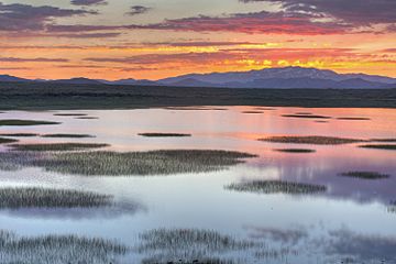
The Bodie Hills are a group of small mountains in Mono County, California, USA. They are located between the town of Bridgeport and the Nevada border. On the Nevada side, they are called the Bodie Mountains. The tall Sierra Nevada mountains are to their west. The famous ghost town of Bodie, California is found within the Bodie Hills.
About the Bodie Hills
The Bodie Hills are not as tall as the nearby Sierra Nevada. Their highest point reaches about 2,871 meters (9,419 feet) above sea level. These hills are known for their unique landscape. They have a mix of volcanic rocks and open grasslands.
Native American History
Long ago, the Bodie Hills were home to Native American people. The Mono tribe and Northern Paiute people lived here. They hunted and gathered food in the area. They also traded with other tribes, even those far away. For example, they traded with the Chumash people in Southern California.
Bodie State Historic Park
The old mining town of Bodie is now a ghost town. It is protected as Bodie State Historic Park. This park helps save the history of California's mining days. It is also a National Historic Landmark. This means it is a very important historical place in the United States.
Bodie became a California State Historic Park in 1962. After that, it was opened for people to visit. When you go there, you can see buildings and items left just as they were. It looks like the miners just walked away. This gives visitors a real look into the past.
 | Chris Smalls |
 | Fred Hampton |
 | Ralph Abernathy |


