Borroloola facts for kids
Quick facts for kids BorroloolaNorthern Territory |
|||||||||
|---|---|---|---|---|---|---|---|---|---|

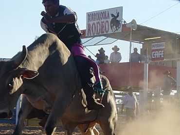
The Borroloola rodeo is held in August each year
|
|||||||||
| Population | 871 (2016 census) | ||||||||
| Postcode(s) | 0854 | ||||||||
| Elevation | 17 m (56 ft) | ||||||||
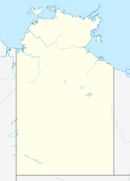
| Location | |||||||||
| LGA(s) | Roper Gulf Region | ||||||||
| Territory electorate(s) | Barkly | ||||||||
| Federal Division(s) | Lingiari | ||||||||
|
|||||||||
Borroloola is a town in Australia's Northern Territory. Its name in the local Garrwa is Burrulula. The town is located on the McArthur River, about 50 kilometers (31 miles) upstream from the Gulf of Carpentaria.
Contents
Where is Borroloola?
Borroloola is located on the traditional lands of the Yanyuwa people. It sits on a flat coastal area between the Barkly Tablelands and the Gulf of Carpentaria. Rivers flowing from the Tablelands often flood during the wet season. This makes it hard to travel on the unsealed parts of Highway One towards Queensland.
The rivers in this area have carved amazing gorges through sandstone. These rivers and coastal areas are home to barramundi fish. This makes Borroloola a popular spot for sports fishing. Deadly saltwater crocodiles also live in these waters. From May to September, the region gets little rain. It is mostly Savanna grasslands with scattered trees.
History of Borroloola
The Garrwa language is spoken in the Gulf region, including Borroloola. The Garrwa name for the town is Burrulula.
Early cattle drovers in the late 1800s used a path called the 'Coast Track'. They moved cattle from north-west Queensland to new stations in the Northern Territory. This path had been used by Aboriginal people for a long time before that.
Borroloola officially became a town on 10 September 1885. In the local Indigenous languages like Yanyuwa, Garrwa, and Marra, the town's name is Burrulula. This name comes from a small lagoon near the town. The lagoon is linked to the Hill Kangaroo Ancestor (Nangurrbuwala). It is said that this ancestor danced his ceremonies at this spot. The white-barked gum trees in the area are believed to be his body decorations that flew off as he danced. Other Indigenous names nearby include Wurrarawala (Trig Hill), which is linked to the Hill Kangaroo's backbone. Bunubunu (Rocky Creek) is linked to a File Snake Ancestor. Warralungku (The McArthur River Crossing) and Mabunji are rocks at the river crossing with the Hill Kangaroo's tail and feet imprints. The Borroloola area belongs to the Rrumburriya clan.
A famous story about Borroloola involves a police officer named Corporal Power. He asked the Carnegie Trust for books for the town's library. He received about 3,000 books, which were stored in the courthouse. Later, in 1923, a man named Bill Harney found the library had fallen apart. Books were damaged or used for other purposes.
In 1963, David Attenborough visited Borroloola to film for his BBC series Zoo Quest. He interviewed Jack Mulholland, who owned the local hotel.
In 1977, the Yanyuwa people were the first to successfully claim land under a new law called the Aboriginal Land Rights (Northern Territory) Act 1976. This claim included Borroloola and the Pellew Islands. The claim was finally settled in 2015. Another land claim in 2002 led to more islands in the area being returned to Indigenous ownership.
John Kundereri Moriarty, a Yanyuwa man born in Borroloola, has received important awards. He helped start the Moriarty Foundation, which supports Aboriginal families and communities.
People of Borroloola
At the 2016 census, Borroloola had a population of 871 people.
- About 76% of the people were Aboriginal and Torres Strait Islander.
- Most people (89%) were born in Australia.
- About 80% of people spoke only English at home.
Things to Do and See
The King Ash Bay fishing club is located on the McArthur River, about 40 kilometers (25 miles) from Borroloola. It has a boat ramp that gives access to the river's waterways and the Sir Edward Pellew Group of Islands. This village has a small number of people living there all year. However, many tourists, especially retired people, visit from April to May to enjoy the dry season. The Fishing Classic competition is held each year around Easter.
The Borroloola Community Education Centre (CEC) includes a 'Families as First Teachers' Centre, a preschool, a primary school, and a secondary school. The CEC has over 25 staff members, including teachers from other states and local Indigenous teacher aides. The school usually has about 100 students attending each day.
Borroloola also has a health center that provides basic medical services.
Waralungku Arts
Waralungku Arts is an art center in Borroloola. It is owned and run by Aboriginal people. It was started in 2003.
Economy
The main ways people make a living in Borroloola are through tourism, mining, and art. The McArthur River zinc mine, one of the world's largest zinc, lead, and silver mines, is about 70 kilometers (43 miles) from Borroloola. In 2006, there were 42 businesses registered in the town.
Getting Around
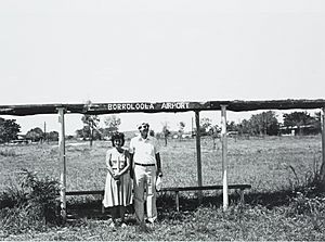
The Borroloola Airport has a runway that is 1,149 meters (3,770 feet) long. The airport can be very busy during the day. Sometimes, Careflight planes use the airport at night for emergencies. A small Cessna plane is based at the airport. It often flies to nearby towns and communities like Robinson River and Katherine. It also offers scenic flights to the Sir Edward Pellew Islands. The airport has fuel and parking areas. Solar-powered lights light up the runway at night.
The Carpentaria Highway goes west from Borroloola to Daly Waters. The Savannah Way goes east from Borroloola to Normanton. Both highways are part of Australia's Highway 1. However, large parts of the Savannah Way are not sealed (they are dirt roads).
Four bus services travel between Katherine and Borroloola each week. Two of these buses continue on to Darwin.
Climate
Borroloola has a tropical savanna climate. This means it has three main seasons: the wet season, the dry season, and the build-up season. Temperatures have been as high as 44.1°C (111.4°F) and as low as 0.4°C (32.7°F).
| Climate data for Borroloola, elevation 16 m (52 ft), (1994–2020 normals, extremes 1987–present) | |||||||||||||
|---|---|---|---|---|---|---|---|---|---|---|---|---|---|
| Month | Jan | Feb | Mar | Apr | May | Jun | Jul | Aug | Sep | Oct | Nov | Dec | Year |
| Record high °C (°F) | 44.2 (111.6) |
42.7 (108.9) |
43.3 (109.9) |
41.5 (106.7) |
37.4 (99.3) |
35.6 (96.1) |
36.2 (97.2) |
37.7 (99.9) |
40.7 (105.3) |
43.0 (109.4) |
44.2 (111.6) |
44.7 (112.5) |
44.7 (112.5) |
| Mean daily maximum °C (°F) | 34.4 (93.9) |
34.2 (93.6) |
34.1 (93.4) |
34.2 (93.6) |
32.4 (90.3) |
30.4 (86.7) |
30.5 (86.9) |
32.1 (89.8) |
35.1 (95.2) |
36.9 (98.4) |
37.7 (99.9) |
36.7 (98.1) |
34.1 (93.3) |
| Mean daily minimum °C (°F) | 24.9 (76.8) |
24.6 (76.3) |
23.4 (74.1) |
20.3 (68.5) |
15.9 (60.6) |
12.9 (55.2) |
12.0 (53.6) |
13.5 (56.3) |
17.5 (63.5) |
21.3 (70.3) |
23.9 (75.0) |
25.2 (77.4) |
19.6 (67.3) |
| Record low °C (°F) | 19.1 (66.4) |
18.4 (65.1) |
14.9 (58.8) |
9.0 (48.2) |
5.3 (41.5) |
2.7 (36.9) |
3.4 (38.1) |
5.1 (41.2) |
7.8 (46.0) |
13.3 (55.9) |
13.2 (55.8) |
18.2 (64.8) |
2.7 (36.9) |
| Average rainfall mm (inches) | 218.8 (8.61) |
223.4 (8.80) |
153.1 (6.03) |
59.5 (2.34) |
7.8 (0.31) |
1.7 (0.07) |
0.5 (0.02) |
0.5 (0.02) |
3.4 (0.13) |
13.5 (0.53) |
68.9 (2.71) |
131.4 (5.17) |
882.5 (34.74) |
| Average rainy days (≥ 1.0 mm) | 12.2 | 11.9 | 10.2 | 3.7 | 0.7 | 0.3 | 0.1 | 0.1 | 0.3 | 1.3 | 4.1 | 8.5 | 53.4 |
| Source: Australian Bureau of Meteorology | |||||||||||||
See also
 In Spanish: Borroloola para niños
 | Mary Eliza Mahoney |
 | Susie King Taylor |
 | Ida Gray |
 | Eliza Ann Grier |


