Brierley facts for kids
Quick facts for kids Brierley |
|
|---|---|
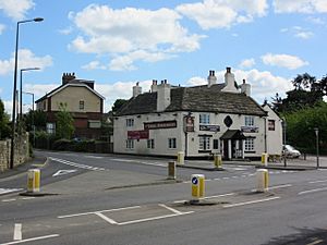
 The Three Horseshoes Pub in Brierley |
|
| Population | 7,267 (2011 census) |
| OS grid reference | SE410110 |
| • London | 150 mi (240 km) SSE |
| Metropolitan borough |
|
| Metropolitan county | |
| Region | |
| Country | England |
| Sovereign state | United Kingdom |
| Post town | Barnsley |
| Postcode district | S72 |
| Dialling code | 01226 |
| Police | South Yorkshire |
| Fire | South Yorkshire |
| Ambulance | Yorkshire |
| EU Parliament | Yorkshire and the Humber |
| UK Parliament |
|
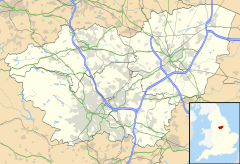
Brierley is a village in South Yorkshire, England. It's part of the Barnsley area. The village is built on a small hill near the border with West Yorkshire. It's less than 2 kilometres (about 1.2 miles) southwest of Hemsworth.
In 2011, about 7,267 people lived in Brierley. The village centre is about 100 metres (330 feet) above sea level.
Contents
A Look at Brierley's History
Brierley is a very old place. It was first settled by the Saxons a long, long time ago.
Ancient Times and Early Settlements
Before the Saxons, there was a fort at Brierley Gap. This fort is much older, probably from the Iron Age. The village started to grow on a hilltop. This spot was good for building because it had a small dip and several wells for water.
People living here long ago knew about coal. This is because coal seams (layers of coal) came right up to the surface along Ket Hill Lane. The ground in this area is made of layers of sandstone and coal.
Brierley in the Domesday Book
In the Domesday Book, a famous survey from 1086, Brierley was called 'Brerelia'. This old book lists many places in England. The name 'Brerelia' later changed to 'Brereley', then 'Brearley'. This is why some people still say "Brearley" today.
The name was first spelled 'Brierley' in some documents from 1572. These papers were about the Brierley Manor. But this spelling didn't become common until 1665.
Old Field Boundaries
If you look at old maps, you can still see the original field boundaries. They form an uneven ring around the village. Their winding shapes show how farmers used to plough the land.
The Manor of Hall Steads
Between Brierley and Grimethorpe, there was once a strong, fortified house called the Manor of Hall Steads. Its name means 'hall site'. This manor house was part of the early Brereley estate. It had a high stone wall and a moat (a ditch filled with water) around it.
The building was mostly made of local sandstone. You can still find pieces of these stones in the ground today. People have also found pottery fragments from the 1300s and 1400s there.
St. Paul's Church
St. Paul's Church in Brierley was built in 1869. It was designed by John Wade in the Gothic Revival style. George Savile Foljambe, who was the Lord of the Manor of Brierley, paid for half of the church's cost. Other local people donated the rest of the money. The land for the church and the old Brierley church school was given by Rev John Hoyland.
Notable People from Brierley
- Winifred Foley (1914–2009) was a writer. She was born in Brierley. She wrote about her childhood in the Forest of Dean.
See also
 In Spanish: Brierley para niños
 | William M. Jackson |
 | Juan E. Gilbert |
 | Neil deGrasse Tyson |


