Briscoe County, Texas facts for kids
Quick facts for kids
Briscoe County
|
|
|---|---|

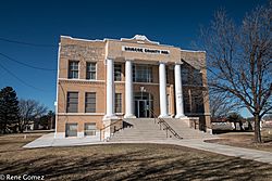
The Briscoe County Courthouse in Silverton
|
|

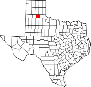
Location within the U.S. state of Texas
|
|
 Texas's location within the U.S. |
|
| Country | |
| State | |
| Founded | 1892 |
| Named for | Andrew Briscoe |
| Seat | Silverton |
| Largest city | Silverton |
| Area | |
| • Total | 902 sq mi (2,340 km2) |
| • Land | 900 sq mi (2,000 km2) |
| • Water | 1.6 sq mi (4 km2) 0.2% |
| Population
(2020)
|
|
| • Total | 1,435 |
| • Density | 1.5909/sq mi (0.6143/km2) |
| Time zone | UTC−6 (Central) |
| • Summer (DST) | UTC−5 (CDT) |
| Congressional district | 13th |
Briscoe County is a place in the U.S. state of Texas. It's like a special district within the state. In 2020, about 1,435 people lived there. The main town, or county seat, is Silverton.
Briscoe County was officially created in 1876. It was later organized in 1892. The county is named after Andrew Briscoe. He was a brave soldier during the Texas Revolution.
A very large cattle ranch, called the JA Ranch, once reached into Briscoe County. This ranch was started by Charles Goodnight and John George Adair. Later, Charles Goodnight owned another ranch called the Quitaque Ranch. A famous high school football and college coach, Gene Mayfield, was born here in 1928.
You can also find Caprock Canyons State Park and Trailway in Briscoe County. It's a great place to explore nature!
Contents
Geography
Briscoe County covers a total area of about 902 square miles. Most of this land is dry, with only a small part being water.
Tule Canyon
Mackenzie Reservoir is a lake formed by holding back water from Tule Creek. This project started in 1972. It is near where Colonel Ranald S. Mackenzie's Fourth Cavalry fought in 1874.
Major Highways
These are the main roads that go through Briscoe County:
Neighboring Counties
Briscoe County shares borders with these other counties:
- Armstrong County (to the north)
- Donley County (to the northeast)
- Hall County (to the east)
- Motley County (to the southeast)
- Floyd County (to the south)
- Swisher County (to the west)
Population Facts
The number of people living in Briscoe County has changed over the years.
| Historical population | |||
|---|---|---|---|
| Census | Pop. | %± | |
| 1880 | 12 | — | |
| 1900 | 1,253 | — | |
| 1910 | 2,162 | 72.5% | |
| 1920 | 2,948 | 36.4% | |
| 1930 | 5,590 | 89.6% | |
| 1940 | 4,056 | −27.4% | |
| 1950 | 3,528 | −13.0% | |
| 1960 | 3,577 | 1.4% | |
| 1970 | 2,794 | −21.9% | |
| 1980 | 2,579 | −7.7% | |
| 1990 | 1,971 | −23.6% | |
| 2000 | 1,790 | −9.2% | |
| 2010 | 1,637 | −8.5% | |
| 2020 | 1,435 | −12.3% | |
| U.S. Decennial Census 1850–2010 2010 2020 |
|||
In 2020, the population was 1,435 people. Most people in the county identify as White. There are also people of Hispanic or Latino background, and smaller groups of Black or African American, Native American, and people of mixed races.
Education
Students in Briscoe County go to schools in these districts:
- Silverton Independent School District
- Clarendon Independent School District (partially)
- Turkey-Quitaque Independent School District (partially)
Communities
The main towns and communities in Briscoe County are:
See also
 In Spanish: Condado de Briscoe para niños

