
Bruny Island facts for kids
|
Native name:
Lunawanna Allonah
|
|
|---|---|
 |
|

Location of the Bruny Island in Tasmania
|
|
| Etymology | Bruni d'Entrecasteaux |
| Geography | |
| Location | Tasman Sea |
| Coordinates | 43°22′S 147°17′E / 43.367°S 147.283°E |
| Total islands | 2 |
| Area | 362 km2 (140 sq mi) |
| Highest elevation | 571 m (1,873 ft) |
| Highest point | Mount Mangana |
| Administration | |
| State | Tasmania |
| LGA | Kingborough Council |
| Demographics | |
| Population | 600 |
| Pop. density | 1.6 /km2 (4.1 /sq mi) |
Bruny Island, also known by its traditional Aboriginal name Lunawanna-alonnah, is a beautiful island off the southeast coast of Tasmania, Australia. It covers about 362 square kilometers (140 square miles). The island is separated from mainland Tasmania by the D'Entrecasteaux Channel. Its eastern side faces the Tasman Sea.
Near the island's northeast is Storm Bay, where the Derwent River meets the sea. This area is also the main port for Hobart, Tasmania's capital city. Both the island and the channel are named after Antoine Bruni d'Entrecasteaux, a French explorer. The traditional Aboriginal name, Lunawanna-alonnah, is still used for two towns on the island: Alonnah and Lunawanna.
Contents
Island Geography
Bruny Island is actually made of two land parts: North Bruny and South Bruny. These two parts are connected by a long, thin strip of sand called "The Neck." The island is about 50 kilometers (31 miles) long in total.

North Bruny is home to the holiday village of Dennes Point. In South Bruny, you will find the towns of Alonnah, Adventure Bay, and Lunawanna.
Outside the towns, the island has many fields for grazing animals and large areas of dry eucalyptus forests. Some inland forests have been used for timber. However, large parts, especially along the southeastern coast, are protected as the South Bruny National Park.
The side of the island facing the sea has two long beaches, Adventure Bay and Cloudy Bay. But for the most part, this coast is very rugged, with high cliffs made of dolerite rock. These cliffs can be over 200 meters (656 feet) tall. The side of Bruny Island facing the channel is more protected. It is a popular spot for fishing and boating for both locals and visitors. Adventure Bay is on the eastern side of "The Neck," while Isthmus Bay is on the western side.
You can reach Bruny Island by a car ferry. This ferry service runs between the island and Kettering on the mainland. There is also a small public airport on North Bruny, but it is mostly for small planes and does not have regular flights.
Island Climate
Cape Bruny has an oceanic climate. This means it has mild, fairly dry summers and cool, wet winters.
| Climate data for Cape Bruny (43º29'S, 147º08'E, 60 m AMSL) (1997-2024 and extremes) | |||||||||||||
|---|---|---|---|---|---|---|---|---|---|---|---|---|---|
| Month | Jan | Feb | Mar | Apr | May | Jun | Jul | Aug | Sep | Oct | Nov | Dec | Year |
| Record high °C (°F) | 39.3 (102.7) |
37.3 (99.1) |
39.7 (103.5) |
28.7 (83.7) |
24.5 (76.1) |
18.2 (64.8) |
18.9 (66.0) |
20.6 (69.1) |
26.5 (79.7) |
31.0 (87.8) |
32.9 (91.2) |
39.2 (102.6) |
39.7 (103.5) |
| Mean daily maximum °C (°F) | 20.2 (68.4) |
20.1 (68.2) |
18.8 (65.8) |
16.7 (62.1) |
14.4 (57.9) |
12.5 (54.5) |
12.2 (54.0) |
12.9 (55.2) |
14.5 (58.1) |
15.5 (59.9) |
17.0 (62.6) |
18.6 (65.5) |
16.1 (61.0) |
| Mean daily minimum °C (°F) | 12.3 (54.1) |
12.4 (54.3) |
11.7 (53.1) |
10.1 (50.2) |
8.7 (47.7) |
7.3 (45.1) |
6.7 (44.1) |
6.6 (43.9) |
7.5 (45.5) |
8.3 (46.9) |
9.7 (49.5) |
10.7 (51.3) |
9.3 (48.8) |
| Record low °C (°F) | 6.2 (43.2) |
5.5 (41.9) |
3.6 (38.5) |
2.5 (36.5) |
3.2 (37.8) |
2.6 (36.7) |
1.9 (35.4) |
1.5 (34.7) |
−0.6 (30.9) |
1.5 (34.7) |
2.3 (36.1) |
4.9 (40.8) |
−0.6 (30.9) |
| Average precipitation mm (inches) | 41.7 (1.64) |
52.5 (2.07) |
55.2 (2.17) |
56.4 (2.22) |
69.4 (2.73) |
75.7 (2.98) |
72.5 (2.85) |
87.0 (3.43) |
68.6 (2.70) |
70.4 (2.77) |
55.7 (2.19) |
56.4 (2.22) |
762.5 (30.02) |
| Average precipitation days (≥ 1.0 mm) | 7.3 | 7.1 | 10.0 | 10.6 | 12.3 | 12.1 | 13.0 | 14.1 | 12.7 | 13.0 | 10.2 | 9.4 | 131.8 |
| Average afternoon relative humidity (%) | 63 | 64 | 65 | 67 | 69 | 71 | 70 | 67 | 64 | 65 | 65 | 63 | 66 |
| Average dew point °C (°F) | 9.7 (49.5) |
10.5 (50.9) |
9.6 (49.3) |
8.1 (46.6) |
6.9 (44.4) |
5.7 (42.3) |
5.2 (41.4) |
5.0 (41.0) |
5.3 (41.5) |
6.4 (43.5) |
7.8 (46.0) |
8.5 (47.3) |
7.4 (45.3) |
| Source: Bureau of Meteorology | |||||||||||||
Bruny Island History
Bruny Island was originally home to Aboriginal Tasmanians. Today, many people on the island still identify as Aboriginal.
The first European to see the island was Abel Tasman in November 1642. Later, in 1773, British explorer Tobias Furneaux became the first to land there. He anchored at Adventure Bay for four days. Four years later, in 1777, James Cook visited the same bay. He carved his initials into a tree, which is now remembered with a special plaque. William Bligh also visited Adventure Bay in 1788 and 1792.
The island itself is named after the French explorer Antoine Bruni d'Entrecasteaux. He explored the channel area in 1792 and realized it was an island. It was called Bruni Island until 1918, when its spelling changed to Bruny.
In the early 1800s, people hunted whales off the coast of Bruny Island. Later, in the late 1800s, the island officially opened for European settlement when the timber industry became very important. Many tramways were built to move timber, some pulled by horses and some by special locomotives. Towns like Lunawanna, Alonnah, and Adventure Bay started as timber ports. Today, most of these settlements are popular holiday spots.
Since the 1920s, Bruny Island has become known as a great place for holidays. People come for its surfing beaches, National Parks, and historical sites. More recently, the state government transferred land on the island back to local Aboriginal people.
Island Environment
Bruny Island is very important for birds. It is called an Important Bird Area by BirdLife International. This is because it has the world's largest group of the endangered forty-spotted pardalote. It also has a large number of swift parrots and all 12 bird species that live only in Tasmania. Up to 240,000 pairs of short-tailed shearwaters, also known as Tasmanian muttonbirds, breed here.
In 2021, people became more aware of the growing number of wild cats on the island. These cats can harm the local wildlife. Experts are looking into ways to protect the native animals. While it's hard to remove all wild cats from a big island like Bruny, people are working on different methods to control them.
The island has many types of plants and trees. These include wet forests, coastal heathlands, and dry forests.
Tourism on Bruny Island
Tourism is a big part of Bruny Island's economy. The South Bruny National Park is a major attraction, showing off the island's beautiful natural areas.
The Cape Bruny Lighthouse is a famous Australian landmark. It was first lit in 1838. It was the third lighthouse built in Tasmania and the fourth in all of Australia. It was staffed by people for a very long time until it became automated in 1993. It stopped being used in 1996 and became part of the South Bruny National Park in 2000. You can take guided tours of the lighthouse.
In 2010/11, the number of visitors to Bruny Island grew to 74,600. Most visitors come for a day trip, but about 21,800 people stay overnight. There are many tourism businesses on the island. These include a cheese factory, an oyster farm, a vineyard, a smokehouse, and an art gallery. There are also two eco-cruises, places to stay, and cafes.
Bruny Island Localities
Bruny Island is divided into eleven named areas. The two largest areas are North Bruny and South Bruny. These areas include national parks, state forests, and some grazing lands.
On North Bruny, there are five populated coastal towns: Apollo Bay, Barnes Bay, Dennes Point, Great Bay, and Killora. On South Bruny, there are four towns: Adventure Bay, Alonnah, Lunawanna, and Simpsons Bay.
Gallery
-
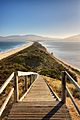
"The Neck" connects the two halves of Bruny Island and is an important breeding site for short-tailed shearwater and fairy penguins
-
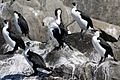
Black-faced cormorants (Phalacrocorax fuscescens), Bruny Island, Tasmania
-
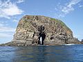
Rock formation off the coast of Bruny Island


See also
 In Spanish: Isla Bruny para niños
