Burleigh Waters, Queensland facts for kids
Quick facts for kids Burleigh WatersGold Coast, Queensland |
|||||||||||||||
|---|---|---|---|---|---|---|---|---|---|---|---|---|---|---|---|

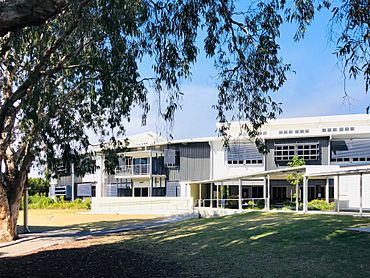
Caningeraba State School, 2020
|
|||||||||||||||
| Population | 14,556 (2021 census) | ||||||||||||||
| • Density | 2,173/km2 (5,630/sq mi) | ||||||||||||||
| Postcode(s) | 4220 | ||||||||||||||
| Elevation | 4 m (13 ft) | ||||||||||||||
| Area | 6.7 km2 (2.6 sq mi) | ||||||||||||||
| Time zone | AEST (UTC+10:00) | ||||||||||||||
| Location |
|
||||||||||||||
| LGA(s) | City of Gold Coast | ||||||||||||||
| State electorate(s) |
|
||||||||||||||
| Federal Division(s) | McPherson | ||||||||||||||
|
|||||||||||||||
Burleigh Waters is a cool suburb on the Gold Coast in Queensland, Australia. It's known for its many lakes and canals. In 2021, about 14,556 people called Burleigh Waters home. It's a great place to live with lots of outdoor activities and schools.
Contents
Exploring Burleigh Waters
Burleigh Waters is part of the Gold Coast. It's close to other suburbs like Burleigh Heads and Miami. You'll find Marymount College and two big shopping centres here.
Lakes and Waterways
One of the coolest things about Burleigh Waters is its amazing canal system. These canals connect to The Broadwater and the Pacific Ocean. This means many homes have waterfront access!
There are five main lakes in Burleigh Waters:
- Lake Heron (28°04′47″S 153°25′34″E / 28.0798°S 153.4261°E)
- Miami Lake (28°04′37″S 153°26′12″E / 28.0769°S 153.4366°E)
- Swan Lake (28°05′20″S 153°25′52″E / 28.0888°S 153.4312°E)
- Pelican Lake (28°04′48″S 153°26′17″E / 28.0800°S 153.4380°E)
- Burleigh Lake (28°05′16″S 153°26′27″E / 28.0877°S 153.4408°E)
The canals have tides, just like the ocean. Sometimes, during very heavy rains, homes along the canals can experience flooding. There's also a special wetland area called Stephens Swamp (28°05′20″S 153°25′43″E / 28.0888°S 153.4286°E).
You can even walk or cycle across Burleigh Lake! There's a bridge connecting Dunlin Drive Link Park to Burleigh Lake Park (28°05′30″S 153°26′14″E / 28.0918°S 153.4372°E).
A Journey Through Time
Burleigh Waters wasn't always full of lakes and canals. A big swamp called Stephens Swamp covered much of the area. In 1861, a local landholder named Thomas Blacket Stephens started draining the swamp.
How Burleigh Waters Grew
In the 1950s, places like the Isle of Capri started building canal estates for people who wanted to live by the water. This idea became very popular. Burleigh Waters began to develop in the 1970s. Developers created new sections with canals and homes.
As the land was drained and reclaimed, the swamp was replaced by the man-made lakes we see today. That's how Burleigh Waters got its name! The suburb was officially named on June 1, 1981. The name Burleigh comes from Burly Head, named by surveyor James Warner in 1840.
Schools and Community
Schools have been an important part of the community for a long time.
- Marymount Primary School opened in Burleigh Waters in 1973. It replaced an older school.
- Marymount College opened in 1967.
- Caningeraba State School opened on January 27, 1987, with 130 students. It helped ease the pressure on other local schools.
- The Burleigh Waters Library opened in 1991, giving everyone a place to read and learn.
Water Safety
For many years, there were stories about sharks in the Gold Coast canals. While many thought it was just a myth, it's always important to be careful around water. In 2003, a serious incident occurred in the canals. This reminded everyone to be safe and swim at the beach, where lifeguards are present.
Who Lives Here?
Burleigh Waters is a diverse place!
- In 2011, there were 13,868 people living here.
- Most people (71.8%) were born in Australia.
- Other people came from countries like New Zealand (7.4%), England (5.5%), and Scotland (0.9%).
- English is the main language spoken at home (88.6%). Some other languages include Japanese, Spanish, and German.
- By 2021, the population had grown to 14,556 people.
Learning in Burleigh Waters
Burleigh Waters has great schools for young people.
Primary Schools
- Caningeraba State School is a government primary school for students from Prep to Year 6. It's located on Whistler Drive (28°05′07″S 153°25′49″E / 28.0853°S 153.4302°E). In 2018, it had over 1,100 students!
- Marymount Primary School is a Catholic primary school, also for Prep to Year 6. You can find it on Reedy Creek Road (28°06′04″S 153°25′46″E / 28.1010°S 153.4294°E). In 2018, it had nearly 1,000 students.
Secondary Schools
- Marymount College is a Catholic secondary school for students in Years 7 to 12. It's on Reedy Creek Road too (28°06′05″S 153°25′49″E / 28.1015°S 153.4304°E). In 2018, over 1,200 students attended the college.
- While there isn't a government secondary school right in Burleigh Waters, students can go to nearby schools like Miami State High School in Miami or Varsity College in Varsity Lakes.
Local Spots and Services
Burleigh Waters has many useful places for its residents.
- Burleigh Waters Library: The Gold Coast City Council runs a public library on Christine Avenue (28°04′53″S 153°25′56″E / 28.0814°S 153.4321°E). It's a great place to borrow books, study, or use computers.
- Post Offices: You can find the Burleigh Town Post Office inside the Stockland Burleigh Heads shopping centre (28°05′52″S 153°26′28″E / 28.0977°S 153.4410°E). There's also another post shop at 6 Classic Way (28°05′58″S 153°25′26″E / 28.0995°S 153.4240°E).
- Mary Mother of Mercy Catholic Church: This church is located on Sunlight Drive (28°06′03″S 153°25′58″E / 28.1009°S 153.4328°E).
 | Misty Copeland |
 | Raven Wilkinson |
 | Debra Austin |
 | Aesha Ash |


