Bushwick Inlet Park facts for kids
Quick facts for kids Bushwick Inlet Park |
|
|---|---|

(2013)
|
|
| Type | Urban park |
| Location | North 9th Street and Kent Avenue Williamsburg, Brooklyn, New York City 11249 United States |
| Area | 8.7 acres (3.5 ha) |
| Operated by | New York City Department of Parks and Recreation |
| Open | All year |
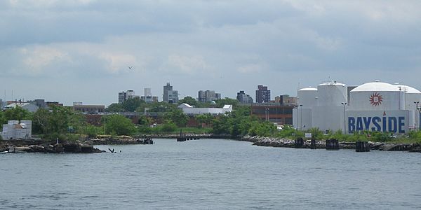
Bushwick Inlet Park is a public park located in the Williamsburg neighborhood of Brooklyn, New York City. This park stretches along the East River between North 9th and 12th Streets. It is planned to extend further north into Greenpoint in the future. The park gets its name from Bushwick Inlet, a small body of water that will be part of its northern section.
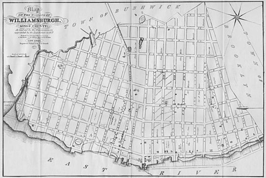
Bushwick Inlet was once a creek called Bushwick Creek. It had two smaller streams feeding into it in Williamsburg. In the mid-19th century, the park's current location was used by factories. Over time, the creek became a place where sewage flowed out. The creek was gradually filled in, with this process finishing by 1913. Ideas for Bushwick Inlet Park began in 2005. This was when a large area in Greenpoint and Williamsburg was being planned for new uses. Buying the land for the park took many years and cost a lot of money. The city finally bought all the land for the park in 2016 after long talks.
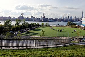
Today, parts of the park are open to everyone. These include soccer and football fields, which opened in 2010. A community center also opened in 2013. This center also has offices for the New York City Department of Parks and Recreation. It was built with features that help the environment. These include a sloped green roof, solar panels, and geothermal heating.
Contents
What is Bushwick Inlet Park?
Bushwick Inlet Park is named after the inlet (a small arm of the sea, lake, or river) that stretches about 1,000 feet (300 m) from the East River. This inlet was originally called Bushwick Creek. It used to be longer and had two sources. One stream reached where McCarren Park is today. The other stream was a bit further south. In 1854, the Brooklyn Eagle newspaper said that the main stream to McCarren Park was the border between Williamsburg and Greenpoint. The area near McCarren Park was once a marsh, but it has since been filled in.
History of the Park Land
How the Area Changed Over Time
Dutch settlers bought the land where Bushwick Inlet Park is now from the Lenape people in 1638. A few years later, in 1645, a couple named Dirck Volkertsen de Noorman and Christina Vigne started the first farm along the creek. This farm was likely near where Franklin and Calyer Streets meet today. In its early days, Bushwick Inlet was sometimes called "Noorman's Kil." Later, the creek was renamed after the nearby town of Bushwick. The town's name comes from the Dutch word Boswijck, meaning "little town in the woods."
The first bridge over Bushwick Inlet was built in 1838 by Neziah Bliss. He also helped develop much of Greenpoint. This bridge connected First Street in Williamsburg (now Kent Avenue) with Franklin Street in Greenpoint. By the mid-19th century, the area became very industrial. Many buildings were put up around the mouth of Bushwick Inlet. Charles Pratt opened the Astral Oil Works factory there in 1857. The land where Astral Oil Works used to be later became the Bayside Fuel Oil depot.
The famous USS Monitor ship was built at the Continental Iron Works near Bushwick Inlet. It was launched in October 1861. The Monitor later fought against the CSS Virginia in the Battle of Hampton Roads during the American Civil War. By 1889, ship manufacturing at Bushwick Creek had mostly stopped.
As early as 1854, people suggested turning Bushwick Creek into a sewer or a canal. The bridge over the creek was replaced in 1869. In 1896, a plan came up to fill in Bushwick Creek and make it a park. By then, the creek was used for sewage, and the bad smell from its standing water bothered nearby homes. Covering the creek was seen as a way to stop these smells. Part of Bushwick Creek was filled in soon after.
The marshy areas near Franklin Street and Kent Avenue were slowly filled in starting in the 19th century. In 1905, a 42-acre (17 ha) section of the former marshlands became part of McCarren Park. All the filling work was finished by 1913. The bridge connecting Franklin Street and Kent Avenue was taken down. During the Prohibition Era in the 1920s, the remaining part of Bushwick Inlet was used to secretly bring in alcohol.
Turning the Land into a Park
In the early 2000s, there were plans to develop the waterfront in Williamsburg and Greenpoint. At the same time, the Greenpoint Monitor Museum wanted to build a park and museum. This museum would honor the USS Monitor at the old Continental Iron Works site. In 2003, the museum got one acre of land near Bushwick Inlet. The museum received $600,000 in 2015. This money came from a settlement related to a cleanup of the Greenpoint oil spill in nearby Newtown Creek.
In 2005, a large area in Greenpoint and Williamsburg was rezoned (meaning its allowed uses were changed). As part of this plan, the city promised to build a 28-acre (11 ha) public park around Bushwick Inlet. This park would be run by the New York City Department of Parks and Recreation. It would be part of a bigger system of waterfront parks, totaling 54 acres (22 ha). The park was expected to cost $80 to $90 million.
The park plans included a path for walking and biking along the shoreline. It would also have areas for kayaking, piers, and fishing. The Monitor Museum was planned for the northern side of the park. Later plans in 2006 also suggested sports fields and a bridge for walkers and bikers. Original ideas for the park even included a large swimming pool. There was also supposed to be a big grassy area, a restaurant terrace, and a scenic viewpoint. A boat launch was planned near the Monitor Museum.
In 2007, the city bought two pieces of land for Bushwick Inlet Park. They used a process called eminent domain, which allows the government to buy private land for public use. This created the first 11-acre (4.5 ha) part of the park. For several years, plans to build the park slowed down. A big challenge was an 11-acre plot with a warehouse for a company called CitiStorage. This land was right in the middle of the proposed park. The city had already spent $95 million to buy the first 8.7-acre (3.5 ha) of land. The owner of CitiStorage wanted a very high price for his land.
Two park facilities started being built in 2009. The soccer and football fields opened in summer 2010. The community center opened three years later in October 2013. By 2015, these were the only parts of the park that had been built. Building these two facilities cost $25.8 million, plus $150 million to buy the land they sit on. The rest of the land the city had bought was not used and became a place for illegal dumping. In April 2014, the city bought land from an oil company for $4.65 million. In December, the city set aside $4.6 million to clean up the Bushwick Inlet site for the future park.
Buying the Last Pieces of Land
In January 2015, the CitiStorage warehouse burned down. After the fire, people strongly urged the city to finish building the park on that site. Residents asked for the park to be completed. At first, Mayor Bill de Blasio did not include the park's completion in his plans. But after many protests from activists, he agreed to buy the remaining land. By this time, the cost of buying land for Bushwick Inlet Park had reached $225 million. This was more than the cost of the entire High Line park in Manhattan.
In 2015, the city announced a deal to buy a 7-acre (2.8 ha) plot from Bayside Fuel. In March 2016, the city bought this land for $53 million. Mayor de Blasio said he would not allow the land to be used for homes. Talks with CitiStorage's owner, Norman Brodsky, continued for over a year after the fire. Local politicians helped mediate between the city and Brodsky. They wanted the CitiStorage site to become part of the park. Other politicians also supported the park.
In July 2016, activists held a "sleep-in" protest at the CitiStorage lot. They wanted to convince the city to buy the land. Activists kept holding protests and rallies. They even organized protests in kayaks and canoes. In November 2016, eleven years after the park was first suggested, Brodsky and the city finally agreed. The city bought the 11-acre CitiStorage site for $160 million. The city now owned almost all the land for Bushwick Inlet Park, except for the Monitor Museum plot. In total, the city spent $350 million on land for the park. This does not include the $25.8 million spent on building the sports fields and community center.
Finishing the Park
In 2016, a plan called "Maker Park" was suggested for the ten old Bayside Oil tanks on the site. This plan wanted to turn the oil tanks into things like a theater and hanging gardens. However, this plan was different from the original park idea, which wanted to tear down the tanks. The city said the oil tanks were very polluted and needed to be cleaned before they could be used as a park. The Maker Park plan was not chosen. The city started taking down the tanks in late 2019.
In October 2017, the city set aside $17.5 million to develop the rest of Bushwick Inlet Park. The Bushwick Inlet Popup Park, a temporary public space, opened in May 2018. It was located between North 11th and North 12th Streets and was open during the summer. A permanent design for this popup park, costing $7.7 million, was approved in late 2018.
In mid-2020, a design for parkland along the inlet was approved. This area is on the former Motiva site. As of January 2021, this part of the park was still being planned. Construction was expected to start later in 2021.
What You Can Find at the Park
Bushwick Inlet Park is part of a planned park area along the industrial waterfront of Greenpoint and Williamsburg. This area will stretch from Newtown Creek to East River State Park. A 3.5-acre (1.4 ha) section of Bushwick Inlet Park is currently open to the public. This part is between North 9th and North 10th Streets. It has playing fields for soccer and American football, plus a playground and restrooms.
The park also has a community center building. This building also holds administrative offices for the park. The offices are on the northern side, facing the East River. The community center is on the southern side, facing Kent Avenue. A non-profit group called the Open Space Alliance runs the community center. Both the fields and the center are on land that used to be a parking lot for car rentals.
The Bushwick Inlet Pop-Up Park is a temporary addition to the park. It is between North 11th and North 12th Streets. This section has a 1.8-acre (0.73 ha) lawn. The permanent plan for this area includes an entrance plaza, a water play area for kids, and a lawn. To the north, along the inlet, is a 1.9-acre (0.77 ha) section. This part will have a shoreline with a beach and a kayak launch.
The inlet itself has plants like Ailanthus and Morus. Some of these are not native to the area. These plants help support the local wildlife. There was also a suggestion to add a safe place for feral cats within the park. The original plan for Bushwick Inlet Park included a boardwalk along the shore of Bushwick Inlet for viewing.
East River State Park is right next to Bushwick Inlet Park. It is managed by the New York state government. Both parks are close to the NYC Ferry stop at North 6th Street.
Green Features of the Park
The roof of the 13,300-square-foot (1,240 m2) community center was designed by Kiss + Cathcart. It has a public landscape where you can look out at the East River and the Manhattan skyline. The building provides spaces for community activities and park operations. It has a green roof that people can walk on. The roof slopes down to the ground on the western side, facing the East River. A winding path goes up the grassy slope, leading to different activity areas. The top of the building has a shaded spot to enjoy the view.
When it opened in 2013, the building was very eco-friendly. It generated a high percentage of its own energy from solar power. Its green roof used only rainwater and reclaimed water for irrigation. It also had zero stormwater going into the sewer system. The building uses less energy because of systems like geothermal heat pumps. A 66-kilowatt photovoltaic array (solar panels) is on top of a shade structure along Kent Avenue. It was designed to create half of the building's yearly energy. Even though the building is partly under a hill, all public indoor areas get light from skylights. In 2014, the Bushwick Inlet Park Community Center was recognized by the American Institute of Architects for its sustainable design.
|
 | Kyle Baker |
 | Joseph Yoakum |
 | Laura Wheeler Waring |
 | Henry Ossawa Tanner |


