Butler County, Alabama facts for kids
Quick facts for kids
Butler County
|
||
|---|---|---|

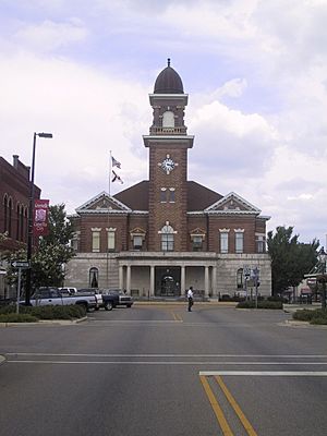
Butler County Courthouse in Greenville
|
||
|
||

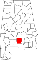
Location within the U.S. state of Alabama
|
||
 Alabama's location within the U.S. |
||
| Country | ||
| State | ||
| Founded | December 13, 1819 | |
| Named for | William Butler | |
| Seat | Greenville | |
| Largest city | Greenville | |
| Area | ||
| • Total | 778 sq mi (2,020 km2) | |
| • Land | 777 sq mi (2,010 km2) | |
| • Water | 1.1 sq mi (3 km2) 0.1% | |
| Population
(2020)
|
||
| • Total | 19,051 | |
| • Estimate
(2023)
|
18,382 |
|
| • Density | 24.487/sq mi (9.455/km2) | |
| Time zone | UTC−6 (Central) | |
| • Summer (DST) | UTC−5 (CDT) | |
| Congressional district | 2nd | |
|
||
Butler County is a county located in the south-central part of the U.S. state of Alabama. In 2020, about 19,051 people lived there. The main town and county seat is Greenville. The county is named after Captain William Butler. He was a soldier who fought in the Creek War and passed away in May 1818.
Contents
History of Butler County
Butler County was created on December 13, 1819. It was formed from parts of Conecuh County, Alabama and Monroe County, Alabama. This happened during the very first meeting of the Alabama Legislature as a state. At first, they thought about naming it Fairfield, but they changed it to Butler to honor Captain William Butler.
People started settling in Butler County a long time ago. Some say it was as early as 1814. The first settler that everyone agrees on was James K. Benson. He moved to the Flat area in 1815 and built a log house. Other families soon followed him, settling near what would become Fort Dale.
Geography of Butler County
Butler County covers a total area of about 778 square miles. Most of this area, 777 square miles, is land. Only a small part, about 1.1 square miles, is water. The county is located in the Gulf Coastal Plain region of Alabama. This area is generally flat and close to the Gulf of Mexico.
Main Roads in Butler County
These are some of the most important roads that go through Butler County:
 Interstate 65
 U.S. Highway 31
 State Route 10
 State Route 106
 State Route 185
 State Route 245
 State Route 263
Neighboring Counties
Butler County shares its borders with these other counties:
- Lowndes County (to the north)
- Crenshaw County (to the east)
- Covington County (to the southeast)
- Conecuh County (to the southwest)
- Monroe County (to the west)
- Wilcox County (to the northwest)
Population of Butler County
| Historical population | |||
|---|---|---|---|
| Census | Pop. | %± | |
| 1820 | 1,405 | — | |
| 1830 | 5,650 | 302.1% | |
| 1840 | 8,685 | 53.7% | |
| 1850 | 10,836 | 24.8% | |
| 1860 | 18,122 | 67.2% | |
| 1870 | 14,981 | −17.3% | |
| 1880 | 19,649 | 31.2% | |
| 1890 | 21,641 | 10.1% | |
| 1900 | 25,761 | 19.0% | |
| 1910 | 29,030 | 12.7% | |
| 1920 | 29,531 | 1.7% | |
| 1930 | 30,195 | 2.2% | |
| 1940 | 32,447 | 7.5% | |
| 1950 | 29,228 | −9.9% | |
| 1960 | 24,560 | −16.0% | |
| 1970 | 22,007 | −10.4% | |
| 1980 | 21,680 | −1.5% | |
| 1990 | 21,892 | 1.0% | |
| 2000 | 21,399 | −2.3% | |
| 2010 | 20,947 | −2.1% | |
| 2020 | 19,051 | −9.1% | |
| 2023 (est.) | 18,382 | −12.2% | |
| U.S. Decennial Census 1790–1960 1900–1990 1990–2000 2010–2020 |
|||
In 2020, the population of Butler County was 19,051 people. There were 6,506 households and 4,331 families living in the county.
Education in Butler County
Butler County has one main public school district. About 3,000 students attend public schools from kindergarten through 12th grade in the county.
School Districts
The main school district serving Butler County is:
- Butler County School District
Communities in Butler County
Butler County has one city, two towns, and several smaller, unincorporated communities.
City
- Greenville (This is the county seat, where the main government offices are.)
Towns
Unincorporated Communities
- Bolling
- Chapman
- Forest Home
- Garland
- Industry
- Pine Flat
- Saucer
- Spring Hill
- Wald
Famous People from Butler County
Many interesting people have connections to Butler County:
- William Butler – A soldier during the Creek War, who the county is named after.
- Hilary A. Herbert – He served as the Secretary of the Navy for President Grover Cleveland.
- Robert Scothrup Lee – A farmer and a veteran of the Confederate army.
- William Lee – A politician, judge, and military officer.
- Warren A. Thompson – An explorer.
- Hank Williams – A very famous country music singer.
- Earnie Shavers – A well-known heavyweight boxer.
- Janie Shores – A justice on the Alabama Supreme Court.
See also
 In Spanish: Condado de Butler (Alabama) para niños
 | Selma Burke |
 | Pauline Powell Burns |
 | Frederick J. Brown |
 | Robert Blackburn |


