Calhoun County, Georgia facts for kids
Quick facts for kids
Calhoun County
|
|
|---|---|

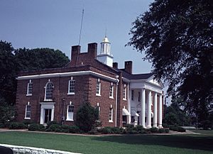
Calhoun County Courthouse in Morgan
|
|

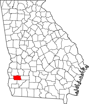
Location within the U.S. state of Georgia
|
|
 Georgia's location within the U.S. |
|
| Country | |
| State | |
| Founded | February 20, 1854 |
| Named for | John C. Calhoun |
| Seat | Morgan |
| Largest city | Morgan |
| Area | |
| • Total | 284 sq mi (740 km2) |
| • Land | 280 sq mi (700 km2) |
| • Water | 3.2 sq mi (8 km2) 1.1%% |
| Population
(2020)
|
|
| • Total | 5,573 |
| • Density | 20/sq mi (8/km2) |
| Time zone | UTC−5 (Eastern) |
| • Summer (DST) | UTC−4 (EDT) |
| Congressional district | 2nd |
Calhoun County is a rural area in the southwestern part of Georgia. It is one of the many counties in the United States. The main town, or county seat, is Morgan. In 2020, about 5,573 people lived there.
Contents
Exploring Calhoun County's Past
Calhoun County was named after John C. Calhoun. He was an important leader who served as the seventh Vice President of the United States. The county was officially created on February 20, 1854. It was formed using parts of Early and Baker counties.
Choosing the County Seat
When the county was new, people disagreed about where the main town should be. Some wanted it in Concord, near present-day Leary. Others preferred Dickey, which was then called Whitney. To solve this problem, they chose a spot right in the middle. This new place became the town of Morgan, and it was made the county seat.
Later, in 1923, the state government decided to move the county seat to Arlington. But just a few years later, in 1929, they changed their minds. Morgan was made the county seat again, and it has been ever since.
Important Places and Services
Calhoun Memorial Hospital in Arlington helped people for 62 years. It closed in 2013. In 2008, a group in Arlington started something called the South Georgia Regional Information Technology Authority (SGRITA). They wanted to bring wireless internet to many rural areas in southwest Georgia. SGRITA moved its office to Blakely in 2017.
Geography and Nature
Calhoun County is home to the historic Calhoun County Courthouse in Morgan. The county covers about 284 square miles. Most of this area, about 280 square miles, is land. The rest, about 3.2 square miles, is water.
Waterways and Land
Most of Calhoun County is part of the Ichawaynochaway Creek area. This creek flows into the larger Apalachicola-Chattahoochee-Flint River Basin. The western and southwestern parts of the county are in the Spring Creek area, which also connects to the same big river basin.
Much of the land in Calhoun County is considered excellent for farming. This means it's great for growing crops. You can also find many farms and forests along the eastern side of the county.
Nearby Counties
Calhoun County shares its borders with several other counties:
- Terrell County (to the northeast)
- Dougherty County (to the east)
- Baker County (to the southeast)
- Early County (to the southwest)
- Clay County (to the west)
- Randolph County (to the northwest)
Towns and Communities
Calhoun County has several towns and smaller communities.
Cities
- Arlington (partly in Early County)
- Edison
- Leary
- Morgan
Unincorporated Communities
These are smaller communities that are not officially cities:
- Dickey
- Williamsburg
Population and People
| Historical population | |||
|---|---|---|---|
| Census | Pop. | %± | |
| 1860 | 4,913 | — | |
| 1870 | 5,503 | 12.0% | |
| 1880 | 7,024 | 27.6% | |
| 1890 | 8,438 | 20.1% | |
| 1900 | 9,274 | 9.9% | |
| 1910 | 11,334 | 22.2% | |
| 1920 | 10,225 | −9.8% | |
| 1930 | 10,576 | 3.4% | |
| 1940 | 10,438 | −1.3% | |
| 1950 | 8,578 | −17.8% | |
| 1960 | 7,341 | −14.4% | |
| 1970 | 6,606 | −10.0% | |
| 1980 | 5,717 | −13.5% | |
| 1990 | 5,013 | −12.3% | |
| 2000 | 6,320 | 26.1% | |
| 2010 | 6,694 | 5.9% | |
| 2020 | 5,573 | −16.7% | |
| 2023 (est.) | 5,457 | −18.5% | |
| U.S. Decennial Census 1790-1880 1890-1910 1920-1930 1930-1940 1940-1950 1960-1980 1980-2000 2010 2020 |
|||
In 2020, there were 5,573 people living in Calhoun County. About 4% of the people were under 5 years old. Almost 17% were under 18, and about 16.6% were 65 or older. About 39% of the population was female. A small number, about 4.1%, were born in other countries. For those aged 5 and older, about 7.7% spoke a language other than English at home.
There were 1,736 households in the county. On average, each household had about 2.56 people. Most homes, about 65.6%, were owned by the people living in them.
Economy and Jobs
Farming is a big part of Calhoun County's economy. Many farms here grow crops like corn, oats, sorghum, and wheat.
Calhoun State Prison in Morgan is one of the largest employers in the county. Calhoun Nursing Home in Edison, which cares for older people, is now run by Miller County.
Education and Learning
The Calhoun County School District helps educate students in the area. It has an elementary school and a middle-high school, both located in Edison. The district serves about 530 students.
Pataula Charter Academy is another school option. It opened in 2010 in Edison. This public charter school is free to attend and serves students from kindergarten through 12th grade. It has about 609 students and helps several counties in southwest Georgia.
The Calhoun County Library in Edison is part of the Kinchafoonee Regional Library System. It provides books and resources for everyone in the community.
Roads and Travel
Several important highways run through Calhoun County, making it easy to travel around.
 State Route 37
 State Route 41
 State Route 45
 State Route 55
 State Route 62
 State Route 216
 State Route 234
See also
 In Spanish: Condado de Calhoun (Georgia) para niños

