Campgaw Mountain facts for kids
Quick facts for kids Campgaw Mountain |
|
|---|---|

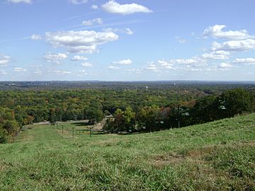
Ski slope in Campgaw Mountain Reservation
|
|
| Highest point | |
| Elevation | 752 ft (229 m) |
| Geography | |
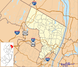
| Location | Bergen County, New Jersey, U.S. |
| Topo map | USGS Ramsey |
| Geology | |
| Age of rock | 200,000,000 years |
| Mountain type | extrusive igneous / trap rock |
| Climbing | |
| Easiest route | Hike |
Campgaw Mountain is a cool place in New Jersey, USA. It's the most northern part of the Watchung Mountains, which were made by volcanoes a long time ago. This mountain sits on the edge of three towns: Franklin Lakes, Oakland, and Mahwah.
Most of Campgaw Mountain is inside the Campgaw Mountain Reservation. This park is a great spot for outdoor fun. It even has the only ski slope in the Watchung Mountains! People often think Campgaw Mountain is part of the bigger Ramapo Mountains. But its plants and rocks are actually quite different. They are more like the Preakness Range to the south.
Contents
What is Campgaw Mountain Like?
Campgaw Mountain stretches about three miles from north to south. It forms a border between Franklin Lakes, Oakland, and Mahwah. The highest point of the mountain is 752 feet (229 meters) tall. This makes it the fourth highest peak in the Watchung Mountains.
There's a small gap between Campgaw Mountain and the Preakness and Goffle Hill ranges. This makes Campgaw seem a bit separate from the other Watchung Mountains. But underground, the rocks are all connected. To the north, the mountain ends at the Ramapo Fault. This fault is the western edge of the Newark Basin. Campgaw Mountain also forms the eastern side of the Ramapo River Valley. This creates a large bowl-shaped area between Campgaw and the Ramapo Mountains.
A unique thing about Campgaw Mountain is that it includes parts of both the First and Second Watchung Mountains. A small stream called Fyke Brook runs through a narrow valley. This brook divides the two mountain ridges. Most of Campgaw Mountain on the surface is part of the Second Watchung Mountain.
Who Lived on Campgaw Mountain?
Long ago, before Europeans arrived, the Munsee (Minsi) Lenape people lived on Campgaw Mountain. We know they were there because of an old village site. This village was on the north side of the mountain, near the Ramapo River. The mountain's name, Campgaw, comes from a Lenape chief named Kum-Kow. The name Kum-Kow might mean goose-hedgehog.
In 1834, people wrote that the top parts of Campgaw Mountain were used for farming. This helps explain why there are so many stone walls in the woods. These walls were probably old property lines. By 1894, a report on New Jersey's forests showed that Campgaw Mountain was covered in trees. These included chestnut, oak, and redcedar. This suggests that farming on the mountain had probably stopped by then.
By 1960, Campgaw Mountain was mostly wilderness. That year, Bergen County bought land on the mountain. They wanted to create the Campgaw Mountain Reservation. The park opened in June 1961. Some Ramapough Mountain Indians who lived on or near Campgaw Mountain moved from their homes when the park was created.
Cold War History
During the Cold War, a Nike missile base was built on Campgaw Mountain. This happened between 1955 and 1971. The missiles were there to protect New York City from enemy planes. They were ready to stop Soviet bombers that might carry nuclear weapons. The base was later closed. This was because new missiles could travel across continents.
How Campgaw Mountain Formed
Campgaw Mountain was made when hot, melted rock came out of the ground. This happened about 185 million years ago. At that time, the mountain was part of a valley that was splitting apart. This valley ran through northern and central New Jersey and parts of Pennsylvania. Later, the valley stopped splitting. Then, the mountain was lifted up as softer rocks around it wore away. This left the hard basalt lava flows of Campgaw Mountain.
The main part of the mountain is mostly made of Preakness Basalt. This rock is an extension of the Second Watchung Mountain. But the northeast part of the mountain has Orange Mountain Basalt. This is because the First Watchung Mountain ridge appears there. The combined ridges of the First and Second Watchung Mountains turn slightly west. They then end at the Ramapo Fault. This marks the very northern end of the Watchung Mountains.
Campgaw Mountain looks a bit separate from the rest of the Watchungs. This is because it sits in a "downfold" in the rock layers. This downfold is also a bit separate from the main Watchung downfold. This means that as you travel north from the Preakness Range and Goffle Hill, the Watchung ridges seem to dip underground. Then, they pop back up as Campgaw Mountain. Even with this gap on the surface, Campgaw Mountain is still connected to the rest of the Watchungs underground.
Plants and Animals of Campgaw Mountain
Campgaw Mountain has a special natural environment. It's different from the nearby Ramapo Mountains. The U.S. EPA says Campgaw Mountain is in a unique "ecoregion." This ecoregion is called "trap rock and conglomerate upland." It's similar to the nearby Preakness Range. In this area, the soil is thin and drains water well. You'll find many oak forests here. Also, hemlock forests are common on slopes that face north. These are clearly seen on the northeastern side of Campgaw Mountain.
Besides oak trees, chestnut and redcedar trees were once very common on Campgaw Mountain. Today, the chestnut trees are gone. This happened because of a disease called chestnut blight that arrived in the early 1900s. However, redcedar trees are still very common on the mountain's ridge. This is different from nearby Goffle Hill, where almost all redcedars are gone. They are also rare in the Preakness Range.
Fun Things to Do
- Campgaw Mountain Reservation is a great place to visit.
- There are two 18-hole disc golf courses at Campgaw.
- The longer course is called Mighty Gaw.
- The shorter course has two starting points for each hole. This makes it fun for players of all skill levels.
 | Delilah Pierce |
 | Gordon Parks |
 | Augusta Savage |
 | Charles Ethan Porter |


