
Canna, Scotland facts for kids
| Gaelic name | Canaigh, Eilean Chanaigh |
|---|---|
 Isle of Canna, viewed from Rum |
|
| OS grid reference | NG244058 |
| Coordinates | 57°04′N 6°33′W / 57.06°N 6.55°W |
| Physical geography | |
| Island group | Small Isles |
| Area | 1,130 hectares (4.4 sq mi) |
| Area rank | 46 |
| Highest elevation | Càrn a' Ghaill 210 metres (689 ft) |
| Administration | |
| Sovereign state | United Kingdom |
| Country | Scotland |
| Council area | Highland |
| Demographics | |
| Population | 15(October 2021) |
| Population density | 1 person/km2 |
| Location | Isle of Sanday Highland Scotland United Kingdom |
|---|---|
| Coordinates | 57°02′50″N 6°27′57″W / 57.0471°N 6.4659°W |
| Year first constructed | 1907 |
| Construction | metal tower |
| Tower shape | cylindrical tower with balcony and lantern |
| Markings / pattern | white tower and lantern |
| Height | 9 metres (30 ft) |
| Focal height | 32 metres (105 ft) |
| Characteristic | Fl W 6s. |
Canna (pronounced like "canna" in "can not") is a small island in Scotland. It's the most western island in a group called the Small Isles. Canna is connected to its nearby island, Sanday, by a road and sandbanks that show up when the tide is low. The island is about 4.3 miles (7 km) long and 1 mile (1.6 km) wide.
Canna and Sanday were given to the National Trust for Scotland in 1981. This gift came from their previous owners, John Lorne Campbell and Margaret Fay Shaw, who were important experts in Scottish culture. The National Trust now manages the islands as a farm and a special area for nature.
Canna House, one of the main buildings, holds a huge collection of Scottish Gaelic stories, songs, and traditions. This collection was put together by Shaw and Campbell. The National Trust has tried to bring more people to Canna, but it's been a bit tricky. In 2017, the Trust decided to let the island community take charge of finding new residents.
Contents
What can you find on Canna?
There are about 20 buildings on Canna and Sanday. These include three churches, though one is no longer used as a church. There's also a post office, which used to be a garden shed!
You can visit Cafe Canna for a bite to eat. The island also has a small shop where you can buy things. It works on an 'honesty' system, meaning you pick what you want and leave the money.
Canna has a telephone line and internet access, but you won't get mobile phone signal. Electricity comes from a diesel generator, and the island has its own water supply.
Safety and travel
Canna is a very safe place with very little crime. A police officer from the mainland visits twice a year. A doctor from the nearby island of Skye also visits once a month if needed.
The roads on Canna are not paved and are privately owned. This means local vehicles don't need to pay road tax. A new road bridge now connects Canna to Sanday, making it easier to travel between them at all times.
Amazing wildlife and nature
Canna is famous for its amazing wildlife! You can spot impressive birds like sea eagles, golden eagles, and puffins. Recently, even peregrine falcons and merlins have been seen. The island is also home to some rare types of butterflies. If you look out into the water, you might see dolphins and smaller whales swimming by.
The island has cool rock formations called basalt pillars, which look like tall columns. These are found on the eastern side of the island. The northern coast has dramatic sea cliffs.
Compass Hill: A magnetic mystery
The highest point on Canna is called Càrn a' Ghaill, which means "rocky hill of the storm" in Gaelic. It's about 689 feet (210 meters) high.
Another interesting spot is Compass Hill, which is 456 feet (139 meters) tall. It's made of a special volcanic rock called tuff. This rock has so much iron in it that it can mess with ship compasses nearby! Instead of pointing north, the compasses point directly to Compass Hill.
A look into Canna's past
.jpg)
Ancient times
An Coroghon is an old site on a tall, isolated rock at the east end of Canna. People think it might have been an ancient fort. Later, a medieval prison tower was built there. In 1772, a visitor named Thomas Pennant described it as a "lofty slender rock" with a small tower high up, reached by a "horrible path." Legend says a jealous ruler built it to keep his beautiful wife locked away.
Early Christian history
Canna was connected to the famous monastery of Iona as early as the 7th century. There are two carved stone crosses on the island, one from the 10th century with a unique design that might show Viking influence.
On the south coast, there are remains of an early Christian fort called Sgorr nam Ban-naomha. Its Gaelic name means "grassy slope of the holy women." In the 1800s, locals believed it had a healing spring and that nuns once lived there. In 2012, a very old "cursing stone" from around 800 AD was found on Canna. It was the first one ever found in Scotland!

Viking Age
From the 800s to 1266, the Norse people (Vikings) and their allies ruled the Hebrides, including Canna. We don't have many written records from this time, but Viking influence can be seen in place names on the island, like Sanday, which means "sand island." There's also a burial site called Uaigh Righ Lochlainn, which means "The grave of the King of Norway."
Medieval Scotland
Canna was likely controlled by the church for a long time. In 1549, it was described as a "fair mainland" with a church, good for farming, fishing, and grazing animals. It also had a falcon's nest!
After the Jacobite Rising of 1745, a Royal Navy ship visited Canna in 1746. The crew demanded cows from the islanders. Sadly, during this time, some island women were chased by soldiers, and one pregnant woman died.
Later, the island was sold to private owners. In 1827, it was bought by Donald MacNeil.
Modern times
A' Chill was the main village on Canna until 1851. At that time, many people were forced to leave the island during a period known as the Highland Clearances.
In 1938, John Lorne Campbell bought Canna. He lived there until he passed away in 1996. He gave the island to the National Trust for Scotland in 1981. His wife, Margaret Fay Shaw, an American musician, stayed at Canna House until she died in 2004 at the age of 101.
Canna's own stamps
In 1958, John Lorne Campbell, who owned Canna at the time, issued a special local stamp for the island. The stamp shows Compass Hill and two Manx shearwaters, a type of seabird common on Canna. People can buy these stamps, and all the money goes to a charity that helps shipwrecked sailors.
How Canna's population has changed
Records show how many people have lived on Canna and Sanday over the centuries. After the Clearances, the population stayed around 20 to 30 people for a long time. By 2001, it had dropped to just 12 people (including Sanday). However, new residents have moved to the island since then. In 2015, the population of Canna had risen to 19 people.
| Year | c. 1595 | 1728 | 1750 | 1755 | 1764 | 1768 | 1772 | 1794 | 1807 | 1821 | 1831 | 1841 | 1851 | 1861 | 1881 | 1891 | 1931 | 1961 | 1981 | 1991 | 2001 | 2011 | 2014 |
|---|---|---|---|---|---|---|---|---|---|---|---|---|---|---|---|---|---|---|---|---|---|---|---|
| Canna population | 57 | 40 | 40 | 24 | 11 | 20 | 6 | 12 | 11 | ||||||||||||||
| Sanday population | 62 | 62 | 20 | 0 | 7 | 0 | 6 | 9 | 7 | ||||||||||||||
| Total population | 84-100 | c.253 | 210 | 231 | 253 | 233 | 220 | 304 | 300 | 436 | 264 | 255 | 238 | 127 | 119 | 102 | 60 | 24 | 18 | 20 | 12 | 21 | 18 |
Getting to Canna

Canna has a large natural harbour, a safe place for boats. The pier on Canna was rebuilt in 2005. The Caledonian MacBrayne ferry, MV Lochnevis, uses this pier. This ferry connects Canna and the other Small Isles (Rùm, Eigg, and Muck) to the mainland port of Mallaig. The trip takes about 2.5 hours. The Lochnevis can carry cars, but you need permission from the National Trust to bring a vehicle to Canna.
The harbour is very popular with yachts sailing along the west coast of Scotland.
Recent happenings on Canna
Dealing with animal problems
The rat problem
In 2005, there were about 10,000 brown rats on Canna! They were causing big problems for people and especially for the rare Manx shearwater birds. So, a plan was made to remove all the rats. Before this, a special type of woodmouse that lives on the island was moved to a safe place. By the end of 2006, Canna was believed to be rat-free. After that, the number of breeding puffins and razorbills increased, and Manx shearwaters started nesting again for the first time in years!
Too many rabbits
Within four years of getting rid of the rats, Canna faced a new problem: too many rabbits! The rabbits were damaging old historical sites and people's vegetable gardens. The island's restaurant even started serving rabbit meat in pies to help. By 2013, there were an estimated 16,000 rabbits. The next year, a team worked for three months to reduce their numbers, removing about 9,000 rabbits.
Looking for new families
In 2006, the National Trust for Scotland decided to invite two families to live on Canna. They wanted people with skills like building, plumbing, and gardening to help the island community. Over 400 people from all over the world applied! Sheila Gunn and John Clare were chosen in 2007, and Neil and Deborah Baker joined them in 2008. Neil Baker's job was to help restore the beautiful gardens at Canna House.
However, in 2011, it was announced that 12 people were planning to leave the island, including the Bakers and their children. This meant the island's school would have to close temporarily because there would be no school-age children left.
Gaelic Study Centre
One of the churches on Canna was restored and turned into a hostel and study centre. This project was done by the Hebridean Trust. The centre is connected to the huge collection of Scottish Gaelic language, literature, and culture that John Lorne Campbell had gathered. It opened in 2001.
Restoring Canna House
In 2020, big renovations started at Canna House and its gardens. The house was expected to reopen in 2021, but due to the COVID-19 pandemic, the work was delayed. It is now hoped to reopen in 2022.
Images for kids
-
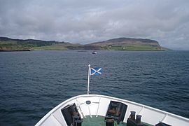
The view from the ferry as it gets closer to Canna Island.
-
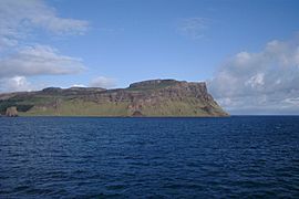
The far east of Canna Island with Compass Hill. On the left is the rock stack called Dùn Mòr.
-
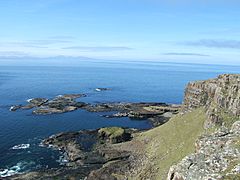
Looking north over Garrisdale point, showing the western cliffs of Canna Island.
-
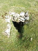
An ancient underground passage (souterrain) on Canna Island.
-
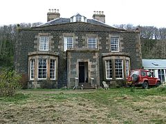
Canna House, a historic building on the island.


See also
 In Spanish: Canna (Escocia) para niños
