
Cape Krusenstern National Monument facts for kids
Quick facts for kids Cape Krusenstern National Monument |
|
|---|---|
|
IUCN Category V (Protected Landscape/Seascape)
|
|
.jpg) |
|

Cape Krusenstern National Monument
Location in Alaska
|
|
| Location | Northwest Arctic Borough, Alaska, United States |
| Nearest city | Kotzebue, Alaska |
| Area | 649,082 acres (2,626.74 km2) |
| Created | December 2, 1980 |
| Visitors | 15,087 (in 2018) |
| Governing body | National Park Service |
| Website | Cape Krusenstern National Monument |
|
Cape Krusenstern Archeological District National Monument
|
|
| Location | Address restricted |
| Nearest city | Kotzebue, Alaska |
| NRHP reference No. | 73000378 |
| Significant dates | |
| Added to NRHP | November 7, 1973 |
| Designated NHL | November 7, 1973 |
Cape Krusenstern National Monument is a special protected area in northwestern Alaska. It's both a U.S. National Monument and a National Historic Landmark. This means it's important for both its natural beauty and its long human history.
The monument is located around Cape Krusenstern. It was created in 1980 to protect its unique features. These include many coastal lagoons and rolling hills. The area is famous for its ancient beach ridges. These ridges show how the coastline has changed over thousands of years. They also hold clues about people who lived there for over 9,000 years.
Cape Krusenstern is entirely above the Arctic Circle. This means it has very cold temperatures and permafrost. Permafrost is ground that stays frozen all year long.
| Top - 0-9 A B C D E F G H I J K L M N O P Q R S T U V W X Y Z |
What is Cape Krusenstern Like?
Cape Krusenstern National Monument stretches along the coast of the Chukchi Sea. It goes from the Kobuk River's mouth up north towards Imikruk Lagoon. The monument also reaches inland about 20 miles (32 km). Its highest points are Kikmiksot Mountain (2,285 feet (696 m)) and Mount Noak (2,010 feet (610 m)).
The coastline has many lagoons. These are separated from the sea by sand spits. The biggest lagoon is Krusenstern Lagoon at Cape Krusenstern. Other lagoons include Kotlik, Imik, and Aukulak Lagoons. The rocks here are mostly limestone and chert. The land was shaped by glaciers long ago. Ocean currents have built up beach ridges for the past 6,000 years.
Ancient Beach Ridges and History
The most important part of Cape Krusenstern is its 114 ancient beach ridges. These ridges formed about 60 years apart. They offer a timeline of human life over 5,000 years. This area is one of the largest National Historic Landmarks in the U.S. It was officially recognized on November 7, 1973.
These beach ridges protect amazing evidence of human life. The Inupiat people have lived here for 5,000 years. Overall, there's proof of people living here for more than 9,000 years. In the late 1940s, archaeologist J. Louis Giddings found campsites on the cape that were 4,000 years old. Even older sites were found on the mainland.
Researchers from the University of Washington have studied about one-third of the 9,000-acre (3,600 ha) beach area. They found old campsites, fire pits, and animal bones. They also found stone tools and pieces of pottery. In newer areas, they found remains of semi-underground houses built into the beach ridges.
The oldest sites, like Battle Rock, are from about 10,000 to 7,000 years ago. Later cultures include the Arctic Small Tool tradition and the Northern Maritime tradition. The Thule culture, which used dogs and seal oil, lived here from 950 AD to 1400. After them came the Kotzebue culture, from 1400 to about 1850. Their sites are found all over the monument.
More Recent History
Europeans started visiting the Cape Krusenstern area in the 1850s to hunt whales. During the American Civil War, a Confederate ship even captured whalers here.
Long ago, the Kotzebue area held a big trade fair called "Iqatngut." Native people from the region would gather to trade goods. This tradition ended when Nome became the main town in the early 1900s. A short gold rush also brought prospectors to the area in the 1890s.
In the 1950s, there was a plan called "Operation Chariot." It suggested using nuclear explosions to create a deep harbor near the monument. However, local leaders were against it, and the project was stopped.
Animals and Nature

The monument is entirely above the Arctic Circle. This means the land is mostly tundra. Tundra is a cold, treeless plain where permafrost is common. The land here is shaped by "thermokarst" forces. These create unique features like pingos (ice-cored hills) and thaw ponds.
Low plants cover the land, like cottongrass and small shrubs. These include willow, Labrador tea, and dwarf birch. Wetter areas have grasses and sedges. In the higher parts, you'll find Arctic tundra plants like lichen and saxifrage. Very few trees grow here, mostly white spruce in the southeast.
The coast is home to many large land and sea animals. You can see many caribou. Large predators include brown bears and wolf packs. Smaller animals like snowshoe hares, Arctic hares, and wolverines also live here.
In the waters near the monument, you might spot fin, bowhead, gray, and beluga whales. Different types of seals, like ringed and bearded seals, are also found. Sometimes, walruses appear. Local people are allowed to hunt some of these animals for food, like ringed seals and sometimes beluga whales or walruses.
Fish species include five types of salmon, burbot, and several kinds of whitefish. Arctic char and northern pike are also found.
Many birds nest in the monument. These include tundra swans, mallards, Canada geese, and sandhill cranes. Seabirds like glaucous gulls and Arctic terns are common. Land birds include willow and rock ptarmigans. You might also see peregrine falcons, snowy owls, and goshawks. Some rare birds, like the spectacled eider, live here too.
Weather in the Arctic
The weather at Cape Krusenstern can be extreme. In January, average low temperatures are 5 °F (−15 °C), but they can drop to −50 °F (−46 °C) at night. Summer temperatures average around 55 °F (13 °C) and can reach 70 °F (21 °C).
Since the park is above the Arctic Circle, the sun doesn't set from June 3 to July 9. In winter, on the shortest day, the sun is only visible for about 1.5 hours. The aurora borealis (Northern Lights) can often be seen on clear winter nights. Snow can fall at any time of year. The coast can be very windy, with gusts up to 70 miles per hour (110 km/h). Visitors need to be careful to stay warm in this cool, damp environment.
Mining and the Environment
The Red Dog mine is the world's largest zinc mine. It opened in 1989, about 30 miles (48 km) northeast of the monument. A road from the mine crosses monument lands to a small port on the coast. This road is used to ship lead and zinc powder when the sea is not frozen. About 20 miles (32 km) of the 55-mile (89 km) road is inside the monument.
Studies have shown that dust from trucks on this road can affect the environment. In 2006, a study found higher levels of lead and cadmium in small animals and birds near the road. This was compared to animals in other areas. After an earlier study, changes were made to the trucks to help control the dust. Now, there is a program to check for dust release regularly.
Protecting the Monument

Cape Krusenstern National Monument was created in 1980. It was one of fifteen new areas protected by the Alaska National Interest Lands Conservation Act (ANILCA). President Jimmy Carter first declared it a national monument in 1978.
Like most national park lands in Alaska, local people are allowed to hunt for food here. About 19% of the monument's land is owned by native corporations.
The main office for the monument is in Kotzebue. This office is also shared with Kobuk Valley National Park and Noatak National Preserve. All these areas are managed together by the National Park Service.
Images for kids
-
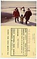
Family on spring ice of Krusenstern Lagoon on an egg hunting trip, 1973
.jpg)
