Capital City Trail facts for kids
Quick facts for kids Capital City Trail |
|
|---|---|

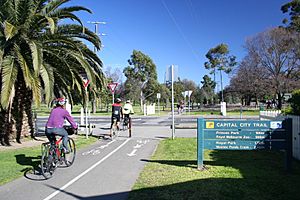
Capital City Trail at Princes Park looking west
|
|
| Length | Approx 29 km |
| Location | Melbourne, Victoria, Australia |
| Cycling details | |
| Trail difficulty | Easy |
| Surface | Shared use concrete or bitumen |
| Hills | Minor hill at Rushall Station |
| Water | Drinking fountains every 2km approx |
| Connecting transport | |
| Train(s) | Going clockwise: Flinders Street, Southern Cross, Flemington Bridge, Rushall and Heyington stations |
The Capital City Trail is a super fun path in Melbourne, Victoria, Australia. It's a special path that people can share, meaning you'll see cyclists, walkers, and joggers all enjoying it. This trail goes in a big circle around Melbourne's city centre and through some of the cool suburbs nearby.
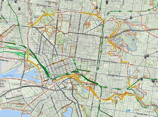
The trail is about 29 kilometres (that's almost 18 miles) long. It's like a puzzle made up of pieces from other famous trails in Melbourne. These include parts of the Merri Creek Trail, Main Yarra Trail, Moonee Ponds Creek Trail, and the old Inner Circle Rail Trail.
A great place to start your adventure on the trail is at Princes Bridge. This bridge is very close to Flinders Street station. From here, you can choose to head east or west. If you go west, you can pick either side of the Yarra River. Many people find the south side of the river a bit more popular for riding.
The Capital City Trail actually shares its path with the Main Yarra Trail for a while. They go together until they reach a spot called Dights Falls. After that, the Capital City Trail continues its loop around the city by joining up with the Merri Creek Trail.
Exploring the Capital City Trail
The Capital City Trail follows the beautiful Yarra River as it winds through Yarra Bend Park. This part of the trail is also known as the Yarra River Trail. Eventually, it meets up with Merri Creek right at Dights Falls.
From Dights Falls, the trail then follows the Merri Creek Trail. It goes along Merri Creek until it reaches Rushall Station. Here, the path changes and follows an old railway line, which is now part of the Inner Circle rail reserve. This section also takes you through the large and lovely Royal Park.
After Royal Park, the Capital City Trail connects with the Moonee Ponds Creek Trail. This trail then leads you all the way back towards Docklands and Southbank. At its furthest point, the trail is about 5 kilometres (or 3 miles) away from the very centre of Melbourne.
Amazing Places You'll See
As you travel along the Capital City Trail, you'll pass by many exciting attractions and famous landmarks. It's like a sightseeing tour on wheels or by foot! Here are some of the cool places you might spot:
- Southbank: A lively area with restaurants and shops along the river.
- Alexandra Gardens and Royal Botanic Gardens: Beautiful parks perfect for a picnic or a stroll.
- Melbourne Park and Melbourne Cricket Ground: Home to big sports events, including the Australian Open tennis tournament.
- Yarra River: The main river flowing through Melbourne.
- Yarra Bend Park: A large natural park with lots of trees and open spaces.
- Collingwood Children's Farm: A fun place where you can meet farm animals.
- Hardy Gallagher Reserve: Another green space along the trail.
- Merri Creek: A smaller creek that joins the Yarra River.
- Princes Park: Home to the Ikon Park football stadium.
- Royal Park: One of Melbourne's largest parks, great for exploring.
- Melbourne Zoo: Where you can see animals from all over the world.
- Moonee Ponds Creek: Another creek that the trail follows.
- Marvel Stadium: A huge stadium where many sports and concerts happen.
- Docklands: A modern waterfront area with cool buildings and boats.
Connecting to Other Trails
The Capital City Trail is like the main hub of a bicycle network in Melbourne. It connects to many other bike paths, like spokes on a wheel. This means you can easily switch from the Capital City Trail to explore other parts of the city!
Starting from the north and going around clockwise, you can connect to:
- The Upfield Rail Trail
- The Merri Creek Trail
- The Yarra River Trail
- The Gardiners Creek Trail
- The Sandridge Trail
- The Maribyrnong River Trail & Hobsons Bay Coastal Trail (you can reach these via the Footscray Road path at Docklands)
- And finally, the Moonee Ponds Creek Trail
The starting point at Princes Bridge is located at coordinates 37.819744° S, 144.968516° E.
 | Stephanie Wilson |
 | Charles Bolden |
 | Ronald McNair |
 | Frederick D. Gregory |


