Carlton Colville facts for kids
Quick facts for kids Carlton Colville |
|
|---|---|
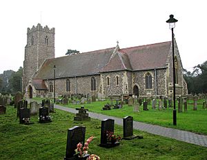
 St Peter's Church, Carlton Colville, seen from the southeast (September 2010) |
|
| Area | 8 km2 (3.1 sq mi) |
| Population | 8,505 (2011) |
| • Density | 1,063/km2 (2,750/sq mi) |
| OS grid reference | TM509905 |
| District |
|
| Shire county | |
| Region | |
| Country | England |
| Sovereign state | United Kingdom |
| Post town | Lowestoft |
| Postcode district | NR33 |
| Dialling code | 01502 |
| EU Parliament | East of England |
| UK Parliament |
|
Carlton Colville is a town located near the sea in the English county of Suffolk. It is about 3 miles (5 km) southwest of Lowestoft, a larger town. You can find Carlton Colville along the A146 road, which connects Lowestoft to Beccles.
The town shares its borders with places like Oulton Broad, Gisleham, and Pakefield. It forms the southwestern edge of Lowestoft. In 2011, about 8,505 people lived here. In August 2011, the local council changed its status to a town council, keeping the same responsibilities.
Contents
Discovering Carlton Colville's Past
Archaeologists have found signs of people living in Carlton Colville from very old times. These discoveries range from the Stone Age to the Middle Ages. For example, three large stone axe heads were found together in a pit. These axes date back to the New Stone Age or early Bronze Age.
Ancient Settlements at Bloodmoor Hill
Between Carlton Colville and Pakefield is a place called Bloodmoor Hill. People lived here during the 2nd and 3rd centuries, and again in the 7th and 8th centuries. During the Saxon period, there was a busy settlement and a burial ground. This cemetery included at least one important burial mound. Old items were first found here in the 1700s. More detailed archaeological digs happened between 1998 and 2006.
Carlton Colville in the Domesday Book
In the year 1086, a famous survey called the Domesday Book was made. Carlton Colville was known as Carletuna or Karletun back then. The survey showed that 45 households lived there. It was part of the land owned by Earl Hugh of Chester.
Medieval Manor Site
South of Carlton Colville, there's a special historical site. It's a moated area, meaning it was once surrounded by a ditch filled with water. Experts believe this was the location of a medieval manor house. This site is now protected as a scheduled monument.
Exploring Local Wildlife
Carlton Colville has always been an interesting place for nature lovers. William Dutt, a famous naturalist, lived in the village for many years. He made notes about plants found by Mrs. F. Baker in a book called Flora of Suffolk. Many of these plants were introduced species, meaning they were brought in from other places. They were often found near an old malthouse and a boatyard. This area was once where grain from far-off lands was unloaded.
Marshes and Nature Reserves
Carlton Colville is located south of the River Waveney. This area includes lots of marshland and reedbeds. A part of this area, called Sprat's Water and Marshes, is a special protected site. It's known as a Site of Special Scientific Interest and covers about 55.5 hectares (137 acres).
Much of this protected land is part of the Carlton and Oulton Marshes Nature Reserve. This reserve is managed by the Suffolk Wildlife Trust and covers 151 hectares (373 acres). These areas are part of The Broads system, which is a network of rivers and lakes. Here, you can find rare water plants like bladderwort and water soldier. It's also home to many different types of dragonfly.
Community Life in Carlton Colville
Carlton Colville is a lively community with several important places and activities.
Schools and Education
The main school for younger students is Carlton Colville Primary School. This school used to be a lower school on Church Lane. However, due to changes by Suffolk County Council, it became a primary school. In September 2011, it moved to the site of the former Gisleham Middle School on Gisleham Road. Another school, Beccles Free School, used the old Carlton Colville Primary School site for a short time. It moved to Beccles in September 2014.
St. Peter's Church
The local church is St. Peter's Church. The oldest parts of this church were built way back in the 13th century. The church has six bells, with the heaviest one weighing over 600 kg. The oldest bell was made in 1608 by William Brend.
East Anglia Transport Museum
Carlton Colville is home to the East Anglia Transport Museum. This museum is a great place to see old buses, trams, and trolleybuses. It's a fun way to learn about how people used to travel.
Local Sports
Carlton Colville also has its own football club, Carlton Colville Town FC. They have two teams: a first team and a development team. These teams play in local football leagues, showing the town's community spirit.
 | Selma Burke |
 | Pauline Powell Burns |
 | Frederick J. Brown |
 | Robert Blackburn |


