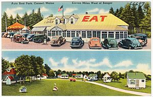
Carmel, Maine facts for kids
Quick facts for kids
Carmel, Maine
|
|
|---|---|

1930s postcard
|
|
| Country | United States |
| State | Maine |
| County | Penobscot |
| Area | |
| • Total | 36.90 sq mi (95.57 km2) |
| • Land | 36.53 sq mi (94.61 km2) |
| • Water | 0.37 sq mi (0.96 km2) |
| Elevation | 161 ft (49 m) |
| Population
(2020)
|
|
| • Total | 2,867 |
| • Density | 78/sq mi (30.3/km2) |
| Time zone | UTC-5 (Eastern (EST)) |
| • Summer (DST) | UTC-4 (EDT) |
| ZIP code |
04419
|
| Area code(s) | 207 |
| FIPS code | 23-10670 |
| GNIS feature ID | 0582390 |
Carmel is a town in Penobscot County, Maine, United States. It is part of the larger Bangor area. In 2020, the town had a population of 2,867 people.
Contents
Geography of Carmel
Carmel covers an area of about 36.9 square miles (95.5 square kilometers). Most of this area is land, with a small part being water. The center of town is where three important roads meet: U.S. Route 2, Maine State Route 100, and Maine State Route 69. A major highway, Interstate 95, also passes through the southern part of Carmel.
Waterways in Carmel
The main waterway flowing through Carmel is Souadabscook Stream. This stream flows east until it reaches the Penobscot River in Hampden. For thousands of years, the Abenaki people used this stream. They traveled on it in canoes to move between the Penobscot and Kennebec River systems.
History of Carmel
The land that is now Carmel was first bought in 1795 by Martin Kinsley from Hampden. He then started selling smaller pieces of land to new settlers. The very first settlers were Abel Ruggles and the Rev. Paul Ruggles. They chose the name "Carmel" to honor the prophet Elijah and his story on Mount Carmel. The area officially became a town in 1811.
Notable People from Carmel
Carmel has been home to several interesting people:
- Myrna Fahey (1933–1973), an actress.
- Amory Nelson Hardy, a photographer.
- Emory A. Hebard, who served in the Vermont House of Representatives and later as Vermont State Treasurer.
- James E. Thorne, a state legislator.
Population and Demographics
The population of Carmel has changed over the years, as shown in the table below:
| Historical population | |||
|---|---|---|---|
| Census | Pop. | %± | |
| 1820 | 153 | — | |
| 1830 | 257 | 68.0% | |
| 1840 | 520 | 102.3% | |
| 1850 | 1,225 | 135.6% | |
| 1860 | 1,271 | 3.8% | |
| 1870 | 1,348 | 6.1% | |
| 1880 | 1,220 | −9.5% | |
| 1890 | 1,066 | −12.6% | |
| 1900 | 932 | −12.6% | |
| 1910 | 1,050 | 12.7% | |
| 1920 | 918 | −12.6% | |
| 1930 | 881 | −4.0% | |
| 1940 | 870 | −1.2% | |
| 1950 | 996 | 14.5% | |
| 1960 | 1,206 | 21.1% | |
| 1970 | 1,301 | 7.9% | |
| 1980 | 1,695 | 30.3% | |
| 1990 | 1,906 | 12.4% | |
| 2000 | 2,416 | 26.8% | |
| 2010 | 2,794 | 15.6% | |
| 2020 | 2,867 | 2.6% | |
| U.S. Decennial Census | |||
Carmel's Population in 2010
According to the census from 2010, there were 2,794 people living in Carmel. These people lived in 1,097 households, with 818 of them being families. The town had about 76.5 people per square mile (29.5 people per square kilometer).
Most of the people in Carmel were White (97.6%). A small number were African American (0.5%), Native American (0.5%), or Asian (0.2%). About 0.8% of the population identified as Hispanic or Latino.
Out of all the households, 34.5% had children under 18 living with them. About 59.5% of households were married couples living together. The average household had 2.55 people, and the average family had 2.90 people.
See also
 In Spanish: Carmel (Maine) para niños
 | Selma Burke |
 | Pauline Powell Burns |
 | Frederick J. Brown |
 | Robert Blackburn |


