Carrington, Nottingham facts for kids
Quick facts for kids Carrington |
|
|---|---|
| Population | 3,118 |
| OS grid reference | SK 56666 42440 |
| District | |
| Shire county | |
| Region | |
| Country | England |
| Sovereign state | United Kingdom |
| Post town | NOTTINGHAM |
| Postcode district | NG5 |
| Dialling code | 0115 |
| Police | Nottinghamshire |
| Fire | Nottinghamshire |
| Ambulance | East Midlands |
| EU Parliament | East Midlands |
| UK Parliament |
|
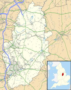
Carrington is a small area located in Nottingham, England. It's about 1.3 miles (2.1 km) north of the main Nottingham city centre. Carrington is surrounded by other areas like Sherwood, Mapperley, Forest Fields, Basford, Sherwood Rise, and the Forest Recreation Ground.
Contents
What's in Carrington?
Carrington is close to the city centre, which makes it a busy place. You can find many local shops and small businesses here. These shops also serve the nearby community of Mapperley Park.
Schools and Services
Carrington is home to Carrington Primary School. In 2013, Ofsted, which inspects schools, rated it as a "Good School." There are also some hotels and guest houses along its main roads, Mansfield Road and Hucknall Road.
Carrington's Past
Carrington has an interesting history, especially with how people used to travel.
Trams and Transport
In the early 1900s, horse-drawn trams used to run along Mansfield Road. They went to stables and a depot located between St. John's Church and Watcombe Road. Later, this tram line was made longer to reach Sherwood. The trams were also upgraded to run on electricity. The old tram depot was later turned into an open-air swimming pool called Carrington Lido. Even later, townhouses were built there.
Community Groups
The 2418 (Sherwood) Squadron of the Air Training Corps is located on Wesley Street. The Air Training Corps is a UK-wide youth organisation. It is sponsored by the Royal Air Force. It helps young people learn about aviation and develop skills.
Modern Changes
In recent years, a new Lidl supermarket was built on Mansfield Road. This shows how Carrington continues to grow and change.
Famous Faces from Carrington
Some notable people have connections to Carrington:
- Anthony Clarke Booth (1846–1899): He received the Victoria Cross. This is the highest award for bravery in the British armed forces. He earned it for his service during the Anglo-Zulu War.
- Chris Staniforth (1895–1954): He was a footballer. He played for teams like Mansfield Town, Notts County, and Oldham Athletic.
 | James B. Knighten |
 | Azellia White |
 | Willa Brown |


